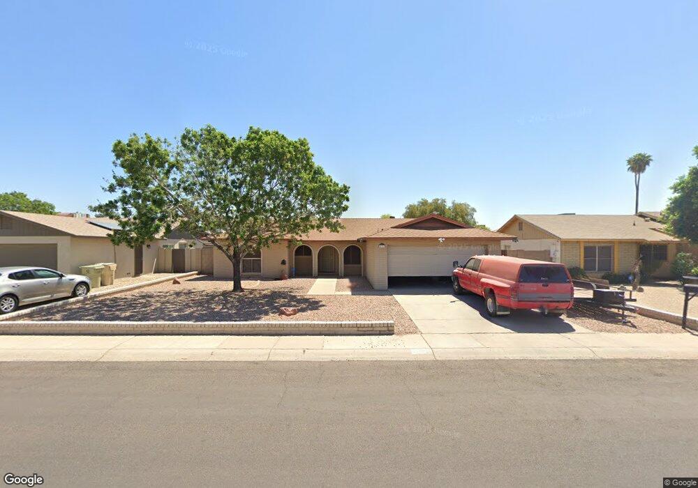
10233 N 53rd Ave Glendale, AZ 85302
Estimated Value: $328,972 - $447,000
--
Bed
2
Baths
1,926
Sq Ft
$211/Sq Ft
Est. Value
About This Home
This home is located at 10233 N 53rd Ave, Glendale, AZ 85302 and is currently estimated at $406,243, approximately $210 per square foot. 10233 N 53rd Ave is a home located in Maricopa County with nearby schools including Heritage School, Ironwood High School, and Heritage Academy - Pointe.
Ownership History
Date
Name
Owned For
Owner Type
Purchase Details
Closed on
Mar 11, 2005
Sold by
Pieper Saundra A and Webb Saundra A
Bought by
Pieper Louis and Pieper Saundra A
Current Estimated Value
Purchase Details
Closed on
Aug 15, 2002
Sold by
Martin Donald E
Bought by
Webb Saundra A
Home Financials for this Owner
Home Financials are based on the most recent Mortgage that was taken out on this home.
Original Mortgage
$127,382
Outstanding Balance
$53,439
Interest Rate
6.43%
Mortgage Type
New Conventional
Estimated Equity
$352,804
Create a Home Valuation Report for This Property
The Home Valuation Report is an in-depth analysis detailing your home's value as well as a comparison with similar homes in the area
Home Values in the Area
Average Home Value in this Area
Purchase History
| Date | Buyer | Sale Price | Title Company |
|---|---|---|---|
| Pieper Louis | -- | Westland Title Agency | |
| Webb Saundra A | $129,500 | North American Title Co |
Source: Public Records
Mortgage History
| Date | Status | Borrower | Loan Amount |
|---|---|---|---|
| Open | Webb Saundra A | $127,382 |
Source: Public Records
Tax History Compared to Growth
Tax History
| Year | Tax Paid | Tax Assessment Tax Assessment Total Assessment is a certain percentage of the fair market value that is determined by local assessors to be the total taxable value of land and additions on the property. | Land | Improvement |
|---|---|---|---|---|
| 2025 | $1,213 | $15,917 | -- | -- |
| 2024 | $1,238 | $15,159 | -- | -- |
| 2023 | $1,238 | $29,220 | $5,840 | $23,380 |
| 2022 | $1,227 | $22,420 | $4,480 | $17,940 |
| 2021 | $1,317 | $20,580 | $4,110 | $16,470 |
| 2020 | $1,336 | $19,310 | $3,860 | $15,450 |
| 2019 | $1,299 | $17,370 | $3,470 | $13,900 |
| 2018 | $1,269 | $16,120 | $3,220 | $12,900 |
| 2017 | $1,277 | $16,000 | $3,200 | $12,800 |
| 2016 | $1,269 | $15,160 | $3,030 | $12,130 |
| 2015 | $1,190 | $14,310 | $2,860 | $11,450 |
Source: Public Records
Map
Nearby Homes
- 5323 W North Ln
- 5210 W Ironwood Dr
- 5407 W North Ln
- 10608 N 53rd Cir
- 5236 W Peoria Ave Unit 202
- 5249 W Mountain View Rd
- 10227 N 56th Dr
- 5131 W Christy Dr
- Faustus Plan at Marlowe
- Malta Plan at Marlowe
- Tamburlaine Plan at Marlowe
- Christopher Plan at Marlowe
- 9710 N 55th Ave
- 4932 W Cheryl Dr
- 4930 W Beryl Ave
- 5209 W Palo Verde Ave
- 9623 N 51st Dr
- 9714 N 55th Dr
- 4924 W Brown St
- 10803 N 55th Ave
- 10239 N 53rd Ave
- 10227 N 53rd Ave
- 10234 N 52nd Dr
- 10240 N 52nd Dr
- 10228 N 52nd Dr
- 10221 N 53rd Ave
- 10245 N 53rd Ave
- 5302 W Cheryl Dr
- 10222 N 52nd Dr
- 5303 W Beryl Ave
- 10246 N 52nd Dr
- 10215 N 53rd Ave
- 10251 N 53rd Ave
- 5308 W Cheryl Dr
- 10216 N 52nd Dr
- 5309 W Beryl Ave
- 5241 W Beryl Ave
- 5242 W Cheryl Dr
- 5301 W Cheryl Dr
- 5246 W Beryl Ave