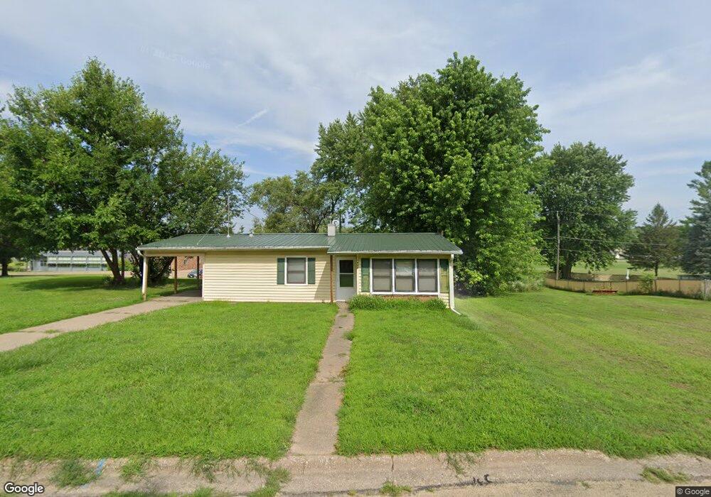
1024 Briarcliff Ln Clinton, IA 52732
Estimated Value: $77,270 - $90,000
3
Beds
1
Bath
977
Sq Ft
$86/Sq Ft
Est. Value
About This Home
This home is located at 1024 Briarcliff Ln, Clinton, IA 52732 and is currently estimated at $84,318, approximately $86 per square foot. 1024 Briarcliff Ln is a home located in Clinton County with nearby schools including Bluff Elementary School, Clinton Middle School, and Clinton High School.
Ownership History
Date
Name
Owned For
Owner Type
Purchase Details
Closed on
Jul 18, 2025
Sold by
Wynkoop-Portz Linda L and Portz Michael J
Bought by
Edox Investments Llc
Current Estimated Value
Home Financials for this Owner
Home Financials are based on the most recent Mortgage that was taken out on this home.
Original Mortgage
$31,302
Outstanding Balance
$31,249
Interest Rate
6.85%
Mortgage Type
Credit Line Revolving
Estimated Equity
$53,069
Create a Home Valuation Report for This Property
The Home Valuation Report is an in-depth analysis detailing your home's value as well as a comparison with similar homes in the area
Home Values in the Area
Average Home Value in this Area
Purchase History
| Date | Buyer | Sale Price | Title Company |
|---|---|---|---|
| Edox Investments Llc | $48,500 | None Listed On Document |
Source: Public Records
Mortgage History
| Date | Status | Borrower | Loan Amount |
|---|---|---|---|
| Open | Edox Investments Llc | $31,302 |
Source: Public Records
Tax History Compared to Growth
Tax History
| Year | Tax Paid | Tax Assessment Tax Assessment Total Assessment is a certain percentage of the fair market value that is determined by local assessors to be the total taxable value of land and additions on the property. | Land | Improvement |
|---|---|---|---|---|
| 2024 | $1,256 | $67,510 | $10,680 | $56,830 |
| 2023 | $1,238 | $67,510 | $10,680 | $56,830 |
| 2022 | $1,156 | $52,877 | $8,797 | $44,080 |
| 2021 | $1,220 | $52,877 | $8,797 | $44,080 |
| 2020 | $1,220 | $52,877 | $8,797 | $44,080 |
| 2019 | $1,260 | $52,877 | $0 | $0 |
| 2018 | $1,228 | $52,877 | $0 | $0 |
| 2017 | $1,262 | $52,877 | $0 | $0 |
| 2016 | $1,222 | $52,877 | $0 | $0 |
| 2015 | $1,222 | $52,877 | $0 | $0 |
| 2014 | $1,226 | $52,877 | $0 | $0 |
| 2013 | $1,210 | $0 | $0 | $0 |
Source: Public Records
Map
Nearby Homes
- 1030 Grandview Dr
- 1214 S 12th St
- 1201 9th Ave S
- 825 11th Ave S
- 1216 9th Ave S
- 831 13th Ave S
- 802 12th Ave S
- 306 18th Place
- 1239 14th Ave S
- 823 14th Ave S
- 605 Melrose Ct
- 765 9th Ave S
- 917 S 8th St
- 610 Argyle Ct
- 602 Kenilworth Ct
- 811 7th Ave S
- 756 13th Ave S
- 1301 Caroline Ave
- 1315 Caroline Ave
- 734 14th Ave S
- 1022 Briarcliff Ln
- 1019 Briarcliff Ln
- 1101 Briarcliff Ln
- 1018 Briarcliff Ln
- 1015 Briarcliff Ln
- 1105 Briarcliff Ln
- 1030 11th Ave S
- 1015 11th Ave S
- 1029 11th Ave S
- 1025 11th Ave S
- 1010 Briarcliff Ln
- 1021 11th Ave S
- 1011 Briarcliff Ln
- 1007 Briarcliff Ln
- 1116 Briarcliff Ln
- 1000 11th Ave S
- 1018 Grandview Dr
- 1018 Grandview Dr Unit Drive
- 1111 Briarcliff Ln
- 1008 Briarcliff Ln