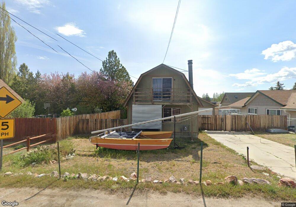
1024 Mount Doble Dr Big Bear City, CA 92314
Estimated Value: $336,000 - $364,624
3
Beds
1
Bath
1,080
Sq Ft
$325/Sq Ft
Est. Value
About This Home
This home is located at 1024 Mount Doble Dr, Big Bear City, CA 92314 and is currently estimated at $351,156, approximately $325 per square foot. 1024 Mount Doble Dr is a home located in San Bernardino County with nearby schools including North Shore Elementary School, Big Bear Middle School, and Big Bear High School.
Ownership History
Date
Name
Owned For
Owner Type
Purchase Details
Closed on
Aug 29, 2007
Sold by
Roach Carola Nan
Bought by
Mastrianna Kenneth
Current Estimated Value
Purchase Details
Closed on
Oct 23, 2000
Sold by
Greenpoint Mtg Funding Inc
Bought by
Roach Carola Nan
Home Financials for this Owner
Home Financials are based on the most recent Mortgage that was taken out on this home.
Original Mortgage
$71,250
Interest Rate
7.86%
Purchase Details
Closed on
Apr 17, 2000
Sold by
Szabo Andy A
Bought by
Greenpoint Mtg Funding Inc
Purchase Details
Closed on
Sep 15, 1997
Sold by
Chin Michael M and Wong Annabelle
Bought by
Szabo Andy A
Home Financials for this Owner
Home Financials are based on the most recent Mortgage that was taken out on this home.
Original Mortgage
$46,900
Interest Rate
7.54%
Mortgage Type
Balloon
Create a Home Valuation Report for This Property
The Home Valuation Report is an in-depth analysis detailing your home's value as well as a comparison with similar homes in the area
Home Values in the Area
Average Home Value in this Area
Purchase History
| Date | Buyer | Sale Price | Title Company |
|---|---|---|---|
| Mastrianna Kenneth | $175,000 | First American | |
| Roach Carola Nan | $75,000 | First American Title Ins Co | |
| Greenpoint Mtg Funding Inc | $32,977 | First American Title Co | |
| Szabo Andy A | $65,000 | First American Title Ins Co |
Source: Public Records
Mortgage History
| Date | Status | Borrower | Loan Amount |
|---|---|---|---|
| Previous Owner | Roach Carola Nan | $71,250 | |
| Previous Owner | Szabo Andy A | $46,900 |
Source: Public Records
Tax History
| Year | Tax Paid | Tax Assessment Tax Assessment Total Assessment is a certain percentage of the fair market value that is determined by local assessors to be the total taxable value of land and additions on the property. | Land | Improvement |
|---|---|---|---|---|
| 2025 | $3,706 | $229,865 | $45,971 | $183,894 |
| 2024 | $3,542 | $225,358 | $45,070 | $180,288 |
| 2023 | $3,437 | $220,939 | $44,186 | $176,753 |
| 2022 | $3,311 | $216,607 | $43,320 | $173,287 |
| 2021 | $3,242 | $212,360 | $42,471 | $169,889 |
| 2020 | $3,254 | $210,183 | $42,036 | $168,147 |
| 2019 | $3,205 | $206,062 | $41,212 | $164,850 |
| 2018 | $2,981 | $192,200 | $39,600 | $152,600 |
| 2017 | $2,844 | $183,000 | $37,700 | $145,300 |
| 2016 | $2,720 | $174,300 | $35,900 | $138,400 |
| 2015 | $2,661 | $170,000 | $35,000 | $135,000 |
| 2014 | $2,399 | $147,200 | $38,200 | $109,000 |
Source: Public Records
Map
Nearby Homes
- 1037 Sequoia Dr
- 304 San Anselmo Dr
- 1056 Sierra Ave
- 1060 Sierra Ave
- 1068 Sierra Ave
- 300 W North Shore Dr
- 332 Grenfall Ln
- 328 E Tiger Lily Dr
- 324 San Anselmo Dr
- 0 N Gold Mountain Dr
- 1017 Greenway Dr
- 913 Mount Doble Dr
- 924 Greenway Dr
- 908 Mount Doble Dr
- 1066 Paradise Way
- 1016 Anita Ave
- 171 W Meadow Ln
- 964 Michael Ave
- 209 W Meadow Ln
- 217 Angeles Blvd
- 1020 Mount Doble Dr
- 204 San Anselmo Dr
- 1016 Mount Doble Dr
- 208 San Anselmo Dr
- 201 Arbor Ln
- 1025 Mount Doble Dr
- 1045 Mount Doble Dr
- 1029 Mount Doble Dr
- 1021 Mount Doble Dr
- 1012 Mount Doble Dr
- 212 San Anselmo Dr
- 1017 Mount Doble Dr
- 1033 Mount Doble Dr
- 1008 Mount Doble Dr
- 1013 Mount Doble Dr
- 0 Mount Doble Dr
- 1037 Mount Doble Dr
- 216 San Anselmo Dr
- 1028 Sequoia Dr
- 209 San Anselmo Dr
Your Personal Tour Guide
Ask me questions while you tour the home.