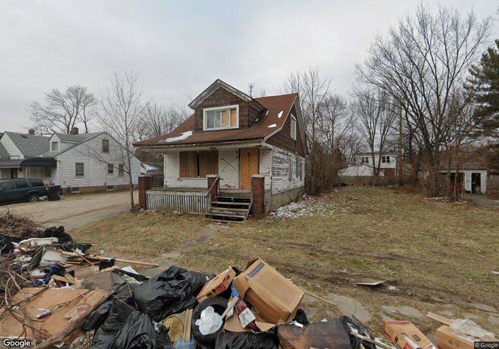
10245 Nottingham Rd Detroit, MI 48224
Outer Drive-Hayes NeighborhoodEstimated Value: $64,000 - $89,000
--
Bed
1
Bath
1,204
Sq Ft
$63/Sq Ft
Est. Value
About This Home
This home is located at 10245 Nottingham Rd, Detroit, MI 48224 and is currently estimated at $75,487, approximately $62 per square foot. 10245 Nottingham Rd is a home located in Wayne County with nearby schools including Wayne Elementary School, Edward 'Duke' Ellington Conservatory of Music and Art, and Charles L. Spain Elementary-Middle School.
Ownership History
Date
Name
Owned For
Owner Type
Purchase Details
Closed on
May 26, 2021
Sold by
Detroit Land Bank Authority
Bought by
Turnage Wimbish Rahim
Current Estimated Value
Purchase Details
Closed on
Jan 13, 2016
Sold by
Wayne County Treasurer
Bought by
Detroit Land Bank Authority
Purchase Details
Closed on
Aug 19, 2011
Sold by
Deutsche Bank National Trust Company
Bought by
Maiden House Ministry
Create a Home Valuation Report for This Property
The Home Valuation Report is an in-depth analysis detailing your home's value as well as a comparison with similar homes in the area
Home Values in the Area
Average Home Value in this Area
Purchase History
| Date | Buyer | Sale Price | Title Company |
|---|---|---|---|
| Turnage Wimbish Rahim | $1,500 | None Available | |
| Detroit Land Bank Authority | -- | None Available | |
| Maiden House Ministry | -- | Attorneys Title Agency Llc |
Source: Public Records
Tax History Compared to Growth
Tax History
| Year | Tax Paid | Tax Assessment Tax Assessment Total Assessment is a certain percentage of the fair market value that is determined by local assessors to be the total taxable value of land and additions on the property. | Land | Improvement |
|---|---|---|---|---|
| 2025 | $1,047 | $17,100 | $0 | $0 |
| 2024 | $1,047 | $14,200 | $0 | $0 |
| 2023 | $1,016 | $10,830 | $0 | $0 |
| 2022 | $1,079 | $9,600 | $0 | $0 |
| 2021 | $1,977 | $0 | $0 | $0 |
| 2020 | $0 | $0 | $0 | $0 |
| 2019 | $1,170 | $0 | $0 | $0 |
| 2018 | $0 | $0 | $0 | $0 |
| 2017 | $930 | $0 | $0 | $0 |
| 2016 | $240 | $9,300 | $0 | $0 |
| 2015 | $930 | $9,300 | $0 | $0 |
| 2013 | $1,259 | $12,878 | $0 | $0 |
| 2010 | -- | $18,880 | $836 | $18,044 |
Source: Public Records
Map
Nearby Homes
- 10172 Somerset Ave
- 10029 Balfour Rd
- 10468 Nottingham Rd
- 10345 Greensboro St
- 10390 Somerset Ave
- 10508 Nottingham Rd
- 10521 Roxbury St
- 10731 Roxbury St
- 10404 Somerset Ave
- 10597 Beaconsfield St
- 10415 Roxbury St
- 10366 Roxbury St
- 9610 Whittier St
- 10811 Roxbury St
- 10713 Beaconsfield St
- 10603 Lakepointe St
- 10336 Roxbury St
- 9910 Somerset Ave
- 10897 Lakepointe St
- 10468 Lakepointe St
- 10251 Nottingham Rd
- 10259 Nottingham Rd
- 10231 Nottingham Rd
- 10237 Nottingham Rd
- 10265 Nottingham Rd
- 10346 Beaconsfield St
- 10352 Beaconsfield St
- 10334 Beaconsfield St
- 10230 Nottingham Rd
- 10225 Nottingham Rd
- 10271 Nottingham Rd
- 10360 Beaconsfield St
- 10242 Nottingham Rd
- 10368 Beaconsfield St
- 10219 Nottingham Rd
- 10318 Beaconsfield St
- 10258 Nottingham Rd
- 10279 Nottingham Rd
- 10250 Nottingham Rd
- 10211 Nottingham Rd