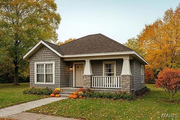
1025 Delano St Poplar Bluff, MO 63901
Estimated payment $765/month
Highlights
- New Construction
- Ranch Style House
- Central Heating and Cooling System
- Eugene Field Elementary School Rated A-
- No HOA
About This Home
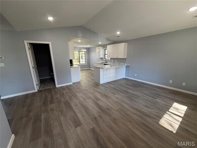
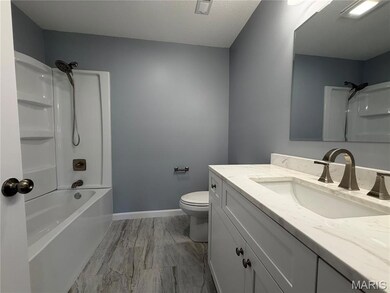
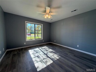
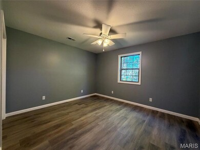
New construction! Built by well known contractor Scott McAllister, this is a charming 2 bedroom, 2 bathroom home with 1073 sq ft +/- of living space. Take advantage of this opportunity to own a brand new home and all that a new home provides! Don't delay!
Home Details
Home Type
- Single Family
Est. Annual Taxes
- $24
Year Built
- Built in 2025 | New Construction
Lot Details
- 5,227 Sq Ft Lot
- Lot Dimensions are 50x106
Home Design
- 1,073 Sq Ft Home
- Ranch Style House
- Vinyl Siding
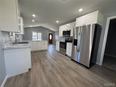
Kitchen
- Electric Oven
- Electric Cooktop
- Dishwasher
Bedrooms and Bathrooms
- 2 Bedrooms
- 2 Full Bathrooms
Location
- City Lot
Schools
- Eugene Field Elem. Elementary School
- Poplar Bluff Jr. High Middle School
- Poplar Bluff High School
Utilities
- Central Heating and Cooling System
- 220 Volts
- Cable TV Available
Community Details
- No Home Owners Association
- Built by McAllister
Listing and Financial Details
- Assessor Parcel Number 13-02-10.0-003-023-023-014.000
Map
Home Values in the Area
Average Home Value in this Area
Tax History
| Year | Tax Paid | Tax Assessment Tax Assessment Total Assessment is a certain percentage of the fair market value that is determined by local assessors to be the total taxable value of land and additions on the property. | Land | Improvement |
|---|---|---|---|---|
| 2024 | $24 | $490 | $0 | $0 |
| 2023 | $24 | $490 | $0 | $0 |
| 2022 | $157 | $3,260 | $0 | $0 |
| 2021 | $157 | $3,260 | $0 | $0 |
| 2020 | $145 | $2,960 | $0 | $0 |
| 2019 | $145 | $2,960 | $0 | $0 |
| 2018 | $145 | $2,960 | $0 | $0 |
| 2017 | -- | $2,960 | $0 | $0 |
| 2016 | -- | $2,960 | $0 | $0 |
| 2015 | -- | $2,960 | $0 | $0 |
| 2014 | -- | $2,770 | $0 | $0 |
| 2012 | $118 | $2,770 | $0 | $0 |
Property History
| Date | Event | Price | List to Sale | Price per Sq Ft |
|---|---|---|---|---|
| 10/31/2025 10/31/25 | Pending | -- | -- | -- |
| 09/26/2025 09/26/25 | For Sale | $144,900 | -- | $135 / Sq Ft |
Purchase History
| Date | Type | Sale Price | Title Company |
|---|---|---|---|
| Warranty Deed | -- | None Listed On Document | |
| Quit Claim Deed | -- | None Listed On Document | |
| Warranty Deed | -- | None Available | |
| Deed | -- | None Available | |
| Warranty Deed | -- | None Available |
Source: MARIS MLS
MLS Number: MIS25066074
APN: 109-13-02-10-0-003-023-014-000
Disclaimer: Certain information contained herein is derived from information provided by parties other than Homes.com. All information provided is deemed reliable, but is not guaranteed to be accurate and should be independently verified.
![]() Based on information submitted to the MLS GRID. All data is obtained from various sources and may not have been verified by broker or MLS GRID. Supplied Open House Information is subject to change without notice. All information should be independently reviewed and verified for accuracy. Properties may or may not be listed by the office/agent presenting the information. Some IDX listings have been excluded from this website.
Based on information submitted to the MLS GRID. All data is obtained from various sources and may not have been verified by broker or MLS GRID. Supplied Open House Information is subject to change without notice. All information should be independently reviewed and verified for accuracy. Properties may or may not be listed by the office/agent presenting the information. Some IDX listings have been excluded from this website.
The Digital Millennium Copyright Act of 1998, 17 U.S.C. § 512 (the “DMCA”) provides recourse for copyright owners who believe that material appearing on the Internet infringes their rights under U.S. copyright law. If you believe in good faith that any content or material made available in connection with our website or services infringes your copyright, you (or your agent) may send us a notice requesting that the content or material be removed, or access to it blocked.
Notices must be sent in writing by email to DMCAnotice@MLSGrid.com.
The DMCA requires that your notice of alleged copyright infringement include the following information:
(1) description of the copyrighted work that is the subject of claimed infringement;
(2) description of the alleged infringing content and information sufficient to permit us to locate the content;
(3) contact information for you, including your address, telephone number and email address;
(4) a statement by you that you have a good faith belief that the content in the manner complained of is not authorized by the copyright owner, or its agent, or by the operation of any law;
(5) a statement by you, signed under penalty of perjury, that the information in the notification is accurate and that you have the authority to enforce the copyrights that are claimed to be infringed; and
(6) a physical or electronic signature of the copyright owner or a person authorized to act on the copyright owner’s behalf. Failure to include all of the above information may result in the delay of the processing of your complaint.
- 1039 Franklin St
- 2121 Pike St
- 2335 Cheshire Blvd
- 712 Nickey St
- 1000 W Victor St
- 622 Nickey St
- 1315 S 11th St
- 1110 Commerce St
- 1905 Kentucky Ave
- 1708 Kentucky Ave
- 2011 Arkansas Ave
- 1910 Arkansas Ave
- 912 Adam St
- 107 W Victor St
- 110 Hampton Ct
- 251 Hampton Ct
- 243 Hampton Ct
- 318 E Henry St
- 813 Kendall Dr
- 205 S B St
