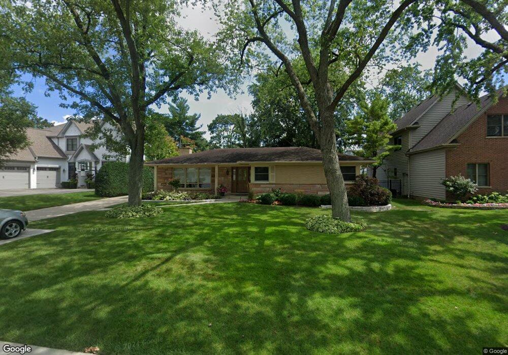
1025 Hillside Ave Deerfield, IL 60015
Estimated Value: $549,000 - $621,000
3
Beds
2
Baths
1,889
Sq Ft
$306/Sq Ft
Est. Value
About This Home
This home is located at 1025 Hillside Ave, Deerfield, IL 60015 and is currently estimated at $578,440, approximately $306 per square foot. 1025 Hillside Ave is a home located in Lake County with nearby schools including Walden Elementary School, Alan B Shepard Middle School, and Deerfield High School.
Ownership History
Date
Name
Owned For
Owner Type
Purchase Details
Closed on
Jun 11, 2001
Sold by
Firstar Bank Na
Bought by
Brown F Quentin and Brown Laurie M
Current Estimated Value
Home Financials for this Owner
Home Financials are based on the most recent Mortgage that was taken out on this home.
Original Mortgage
$100,000
Interest Rate
7.27%
Mortgage Type
Credit Line Revolving
Purchase Details
Closed on
Apr 13, 1995
Sold by
Meisinger Alois G and Meisinger Marion A
Bought by
Meisinger Marion A
Create a Home Valuation Report for This Property
The Home Valuation Report is an in-depth analysis detailing your home's value as well as a comparison with similar homes in the area
Home Values in the Area
Average Home Value in this Area
Purchase History
| Date | Buyer | Sale Price | Title Company |
|---|---|---|---|
| Brown F Quentin | $345,000 | -- | |
| Meisinger Marion A | -- | -- |
Source: Public Records
Mortgage History
| Date | Status | Borrower | Loan Amount |
|---|---|---|---|
| Closed | Brown F Quentin | $100,000 |
Source: Public Records
Tax History
| Year | Tax Paid | Tax Assessment Tax Assessment Total Assessment is a certain percentage of the fair market value that is determined by local assessors to be the total taxable value of land and additions on the property. | Land | Improvement |
|---|---|---|---|---|
| 2024 | $11,798 | $138,919 | $50,245 | $88,674 |
| 2023 | $12,587 | $133,320 | $48,220 | $85,100 |
| 2022 | $12,587 | $138,807 | $51,793 | $87,014 |
| 2021 | $11,869 | $133,828 | $49,935 | $83,893 |
| 2020 | $11,416 | $134,110 | $50,040 | $84,070 |
| 2019 | $11,156 | $133,882 | $49,955 | $83,927 |
| 2018 | $11,461 | $142,911 | $52,948 | $89,963 |
| 2017 | $11,369 | $142,455 | $52,779 | $89,676 |
| 2016 | $11,052 | $137,068 | $50,783 | $86,285 |
| 2015 | $10,816 | $128,787 | $47,715 | $81,072 |
| 2014 | $9,810 | $115,795 | $48,057 | $67,738 |
| 2012 | $9,577 | $114,773 | $47,633 | $67,140 |
Source: Public Records
Map
Nearby Homes
- 1032 Sheridan Ave
- 1030 Chestnut St
- 926 Cedar St
- 1004 Broadmoor Place
- 1054 Broadmoor Place
- 1029 Elmwood Ave
- 1106 Waukegan Rd
- 742 Pine St
- 1285 Warwick Ct
- 1440 Waukegan Rd
- 627 Grove Ave
- 1151 Walden Ln
- 944 Rosemary Terrace
- 525 Mallard Ln
- 1525 Hawthorne Place
- 1625 Marcie Ct Unit 5
- 1327 Central Ave
- 1727 Telegraph Rd
- 1300 Knollwood Rd
- 673 Central Ave
- 1033 Hillside Ave
- 1019 Hillside Ave
- 1024 Oakley Ave
- 1041 Hillside Ave
- 1020 Oakley Ave
- 1036 Oakley Ave
- 1144 Hazel Ave
- 1024 Hillside Ave
- 1128 Hazel Ave
- 1032 Hillside Ave
- 1018 Hillside Ave
- 1045 Hillside Ave
- 1040 Hillside Ave
- 1010 Hillside Ave
- 1122 Hazel Ave
- 1054 Oakley Ave
- 1155 Somerset Ave
- 1046 Hillside Ave
- 1160 Hazel Ave
- 1060 Oakley Ave
Your Personal Tour Guide
Ask me questions while you tour the home.