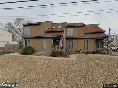
1025 Old Farm Rd Unit 27 Point Pleasant Boro, NJ 08742
Estimated Value: $884,740 - $1,192,000
6
Beds
4
Baths
3,322
Sq Ft
$315/Sq Ft
Est. Value
About This Home
This home is located at 1025 Old Farm Rd Unit 27, Point Pleasant Boro, NJ 08742 and is currently estimated at $1,047,935, approximately $315 per square foot. 1025 Old Farm Rd Unit 27 is a home located in Ocean County with nearby schools including Point Pleasant High School, St Dominic School, and St. Peter School.
Ownership History
Date
Name
Owned For
Owner Type
Purchase Details
Closed on
Feb 1, 2012
Sold by
Sweeney Michael
Bought by
Sweeney Michael and Sweeney Laura
Current Estimated Value
Home Financials for this Owner
Home Financials are based on the most recent Mortgage that was taken out on this home.
Original Mortgage
$195,000
Interest Rate
3.93%
Mortgage Type
New Conventional
Create a Home Valuation Report for This Property
The Home Valuation Report is an in-depth analysis detailing your home's value as well as a comparison with similar homes in the area
Home Values in the Area
Average Home Value in this Area
Purchase History
| Date | Buyer | Sale Price | Title Company |
|---|---|---|---|
| Sweeney Michael | -- | First American Title Ins Co |
Source: Public Records
Mortgage History
| Date | Status | Borrower | Loan Amount |
|---|---|---|---|
| Closed | Sweeney Michael | $195,000 | |
| Closed | Sweeney Michael | $215,000 |
Source: Public Records
Tax History Compared to Growth
Tax History
| Year | Tax Paid | Tax Assessment Tax Assessment Total Assessment is a certain percentage of the fair market value that is determined by local assessors to be the total taxable value of land and additions on the property. | Land | Improvement |
|---|---|---|---|---|
| 2024 | $9,852 | $450,700 | $205,800 | $244,900 |
| 2023 | $9,649 | $450,700 | $205,800 | $244,900 |
| 2022 | $9,649 | $450,700 | $205,800 | $244,900 |
| 2021 | $9,501 | $450,700 | $205,800 | $244,900 |
| 2020 | $9,402 | $450,700 | $205,800 | $244,900 |
| 2019 | $9,275 | $450,700 | $205,800 | $244,900 |
| 2018 | $9,000 | $450,700 | $205,800 | $244,900 |
| 2017 | $8,802 | $450,700 | $205,800 | $244,900 |
| 2016 | $8,735 | $450,700 | $205,800 | $244,900 |
| 2015 | $8,631 | $450,700 | $205,800 | $244,900 |
| 2014 | $8,433 | $450,700 | $205,800 | $244,900 |
Source: Public Records
Map
Nearby Homes
- 1215 Johnson Ave
- 1409 Buckner St
- 1030 Ocean Rd
- 1416 George St
- 1125 Arnold Ave Unit 2
- 1320 Charles St
- 1501 Hulse Rd Unit 18
- 22 Cedar Dr
- 916 Arnold Ave
- 2113 River Rd
- 1320 Bay Ave
- 827 Rosewood Ave
- 284 Osborne Ave
- 1117 Bradford Dr
- 1115 Hollywood Blvd
- 815 Sinclair Rd
- 2118 Kenneth Rd
- 2222 Kenneth Rd
- 820 Trenton Ave
- 1115 Sampson Rd
- 1025 Old Farm Rd Unit 27
- 1029 Old Farm Rd
- 1024 Old Farm Rd
- 1237 John St
- 1022 Old Farm Rd
- 1026 Old Farm Rd
- 1018 Old Farm Rd
- 1242 John St
- 1031 Old Farm Rd
- 335 Route 35 N
- 1113 Dell Dr Unit Dell-dor
- 712 E Albert Clifton
- 504 Route 35
- 0 Confidential Unit 3288590
- 1016 Old Farm Rd
- 1233 John St
- 1238 John St
- 1236 Benedict St
- 1017 Burnt Tavern Rd
- 1024 Burnt Tavern Rd