
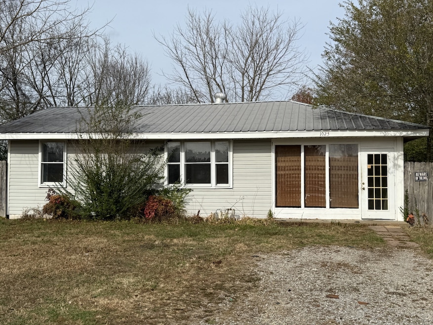
1025 Smith Ave Hohenwald, TN 38462
Estimated payment $629/month
Total Views
47,846
2
Beds
1
Bath
960
Sq Ft
$115
Price per Sq Ft
Highlights
- No HOA
- Level Lot
- Property has 1 Level
- Central Heating and Cooling System
About This Home
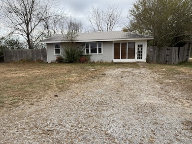
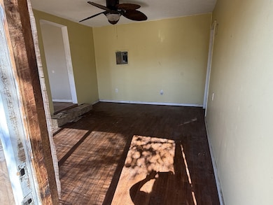
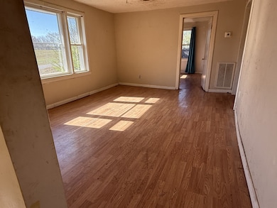
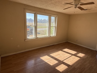
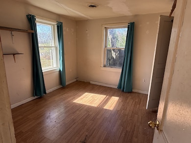
Check out this charming home with a fenced backyard and a handy storage shed! Featuring 2 bedrooms and 1 bathroom, this property is full of potential and ready for someone to bring it back to life.
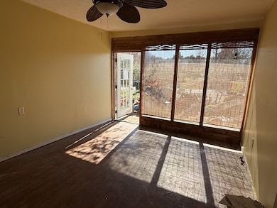
Enjoy the sunroom on the back—perfect for relaxing, plants, or extra storage—and an additional front room that can be used as an office, hobby room, or bonus living area.
With some TLC, this home could be completely transformed to fit your vision. Whether you're looking for a personal project, an investment opportunity, or a great rental property, this home offers endless possibilities.
HVAC 2014.
AS-IS, WHERE-IS — bank sale.
cash only. No utilities are currently on.
Don’t miss out on this solid opportunity!
Listing Agent
Land of The South Realty Brokerage Phone: 6624363736 License # 366822 Listed on: 11/19/2025
Home Details
Home Type
- Single Family
Est. Annual Taxes
- $385
Year Built
- Built in 1955
Lot Details
- 7,841 Sq Ft Lot
- Lot Dimensions are 80x100
- Back Yard Fenced
- Level Lot
Home Design
- Metal Roof
- Vinyl Siding
Interior Spaces
- 960 Sq Ft Home
- Property has 1 Level
- Laminate Flooring
- Crawl Space
- Built-In Electric Oven
Bedrooms and Bathrooms
- 2 Main Level Bedrooms
- 1 Full Bathroom
Parking
- 4 Open Parking Spaces
- 4 Parking Spaces
Schools
- Lewis County Elementary School
- Lewis County Middle School
- Lewis Co High School
Utilities
- Central Heating and Cooling System
- Private Sewer
Community Details
- No Home Owners Association
Listing and Financial Details
- Assessor Parcel Number 036 05501 000
Map
Create a Home Valuation Report for This Property
The Home Valuation Report is an in-depth analysis detailing your home's value as well as a comparison with similar homes in the area
Home Values in the Area
Average Home Value in this Area
Tax History
We collect this data history from publicly available records. To have your information removed, we recommend requesting removal directly through your county’s website.
| Year | Tax Paid | Tax Assessment Tax Assessment Total Assessment is a certain percentage of the fair market value that is determined by local assessors to be the total taxable value of land and additions on the property. | Land | Improvement |
|---|---|---|---|---|
| 2025 | -- | $28,950 | $4,375 | $24,575 |
| 2024 | -- | $12,775 | $2,250 | $10,525 |
| 2023 | $385 | $12,775 | $2,250 | $10,525 |
| 2022 | $385 | $12,775 | $2,250 | $10,525 |
| 2021 | $385 | $12,775 | $2,250 | $10,525 |
| 2020 | $241 | $12,775 | $2,250 | $10,525 |
| 2019 | $317 | $8,700 | $2,000 | $6,700 |
| 2018 | $317 | $8,700 | $2,000 | $6,700 |
| 2017 | $331 | $8,700 | $2,000 | $6,700 |
| 2016 | $331 | $8,700 | $2,000 | $6,700 |
| 2015 | -- | $8,700 | $2,000 | $6,700 |
| 2014 | -- | $8,700 | $2,000 | $6,700 |
| 2013 | -- | $8,325 | $0 | $0 |
Source: Public Records
Property History
We collect this data history from publicly available records. To have your information removed, we recommend requesting removal directly through your county’s website.
| Date | Event | Price | List to Sale | Price per Sq Ft |
|---|---|---|---|---|
| 05/28/2026 05/28/26 | For Sale | $110,600 | 0.0% | $115 / Sq Ft |
| 05/21/2026 05/21/26 | Off Market | $110,600 | -- | -- |
| 05/12/2026 05/12/26 | Price Changed | $110,600 | -5.1% | $115 / Sq Ft |
| 03/11/2026 03/11/26 | Price Changed | $116,500 | -4.9% | $121 / Sq Ft |
| 02/11/2026 02/11/26 | Price Changed | $122,500 | -5.8% | $128 / Sq Ft |
| 11/19/2025 11/19/25 | For Sale | $130,000 | -- | $135 / Sq Ft |
Source: Realtracs
Purchase History
We collect this data history from publicly available records. To have your information removed, we recommend requesting removal directly through your county’s website.
| Date | Type | Sale Price | Title Company |
|---|---|---|---|
| Trustee Deed | $104,173 | None Listed On Document | |
| Warranty Deed | $21,000 | -- | |
| Warranty Deed | $22,000 | -- | |
| Warranty Deed | $5,000 | -- | |
| Deed | -- | -- |
Source: Public Records
Mortgage History
We collect this data history from publicly available records. To have your information removed, we recommend requesting removal directly through your county’s website.
| Date | Status | Loan Amount | Loan Type |
|---|---|---|---|
| Previous Owner | $21,998 | New Conventional |
Source: Public Records
About the Listing Agent
As a Realtor®, I’m known for being dedicated, down-to-earth, and deeply committed to the people I serve. I lead with honesty, communication, and a strong work ethic—because buying or selling a home is one of life’s biggest decisions, and my clients deserve someone who truly shows up for them.
I’m a problem-solver by nature and a helper at heart. I go the extra mile to make every step of the real estate process smooth, organized, and stress-free. Whether I’m negotiating the best deal,
Kirsten's Other Listings
Source: Realtracs
MLS Number: 3048084
APN: 036-055.01
Disclaimer: Certain information contained herein is derived from information provided by parties other than Homes.com. All information provided is deemed reliable, but is not guaranteed to be accurate and should be independently verified.
![]() All data is obtained from various sources and may not have been verified by broker or MLS GRID. Supplied Open House Information is subject to change without notice. All information should be independently reviewed and verified for accuracy. Properties may or may not be listed by the office/agent presenting the information. Some IDX listings have been excluded from this website.
All data is obtained from various sources and may not have been verified by broker or MLS GRID. Supplied Open House Information is subject to change without notice. All information should be independently reviewed and verified for accuracy. Properties may or may not be listed by the office/agent presenting the information. Some IDX listings have been excluded from this website.
Listings courtesy of Realtracs as distributed by MLS GRID.
Based on information submitted to the MLS GRID
Nearby Homes
- 506 Fain St Unit 506 Fain
- 400 Finley Dr
- 34 State Highway 20
- 4205 Tn-50
- 107 W Cooper St
- 445 Southport Rd
- 329 Simpson St
- 410 Manor Dr Unit A3
- 410 Manor Dr Unit C3
- 410 Manor Dr Unit C1
- 410 Manor Dr Unit A4
- 1100 Beckham Ave
- 773 Barren Hollow Rd
- 102 Brink St Unit 1
- 5940 Hassells Creek Ln
- 106 Short Ave
- 329 1st Ave
- 122 E Scott St
- 3308 Fly Rd
- 3312 Fly Rd
Your Personal Tour Guide
Ask me questions while you tour the home.