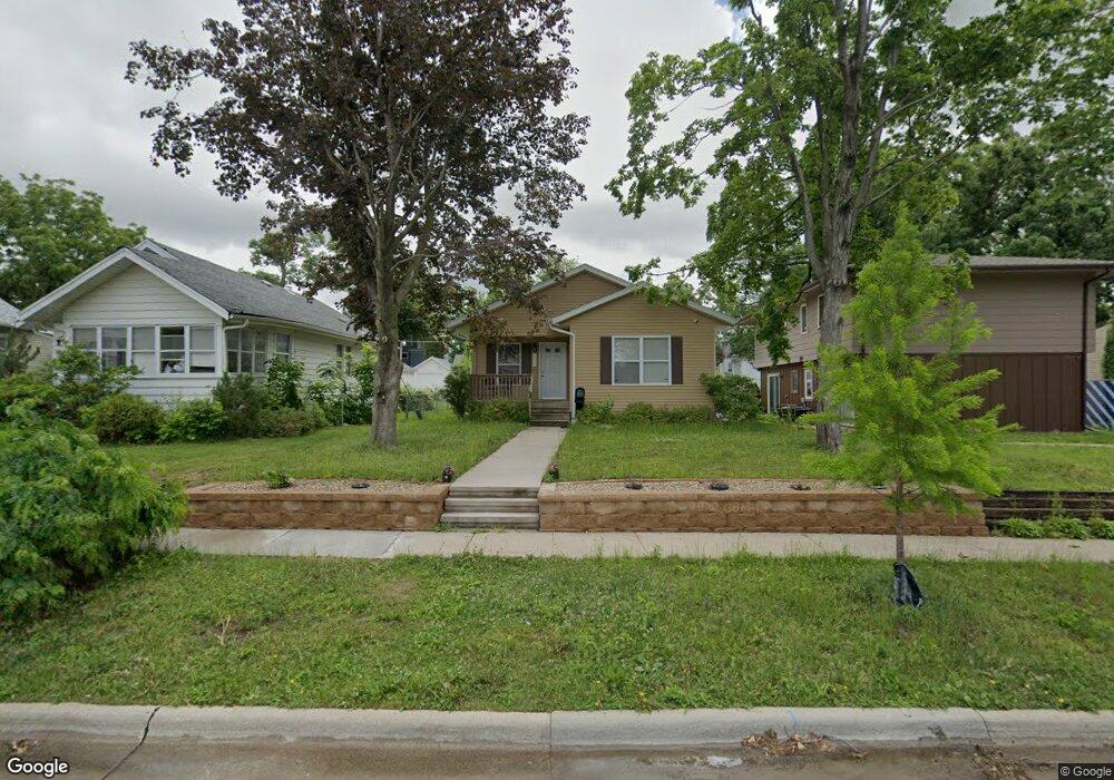
1026 12th St NE Cedar Rapids, IA 52402
Mound View NeighborhoodEstimated Value: $181,000 - $197,329
3
Beds
2
Baths
1,156
Sq Ft
$162/Sq Ft
Est. Value
About This Home
This home is located at 1026 12th St NE, Cedar Rapids, IA 52402 and is currently estimated at $187,332, approximately $162 per square foot. 1026 12th St NE is a home located in Linn County with nearby schools including Franklin Middle School, George Washington High School, and Isaac Newton Christian Academy.
Ownership History
Date
Name
Owned For
Owner Type
Purchase Details
Closed on
Jul 30, 2014
Sold by
Bank Of America Na
Bought by
Habitat For Humanity International Inc
Current Estimated Value
Purchase Details
Closed on
Jun 6, 2014
Sold by
Habitat For Humanity International Inc
Bought by
Cedar Valley Habitat Inc
Purchase Details
Closed on
Dec 10, 2013
Sold by
Madlon Julia L
Bought by
Bank Of America Na
Create a Home Valuation Report for This Property
The Home Valuation Report is an in-depth analysis detailing your home's value as well as a comparison with similar homes in the area
Home Values in the Area
Average Home Value in this Area
Purchase History
| Date | Buyer | Sale Price | Title Company |
|---|---|---|---|
| Habitat For Humanity International Inc | -- | None Available | |
| Cedar Valley Habitat Inc | -- | None Available | |
| Habitat For Humanity International Inc | -- | None Available | |
| Bank Of America Na | $104,558 | None Available |
Source: Public Records
Tax History Compared to Growth
Tax History
| Year | Tax Paid | Tax Assessment Tax Assessment Total Assessment is a certain percentage of the fair market value that is determined by local assessors to be the total taxable value of land and additions on the property. | Land | Improvement |
|---|---|---|---|---|
| 2025 | $3,116 | $196,300 | $20,000 | $176,300 |
| 2024 | $3,276 | $186,500 | $18,000 | $168,500 |
| 2023 | $3,276 | $186,500 | $18,000 | $168,500 |
| 2022 | $2,908 | $164,200 | $17,000 | $147,200 |
| 2021 | $3,138 | $149,300 | $14,000 | $135,300 |
| 2020 | $3,138 | $150,800 | $14,000 | $136,800 |
| 2019 | $2,972 | $146,400 | $14,000 | $132,400 |
| 2018 | $2,886 | $146,400 | $14,000 | $132,400 |
| 2017 | $304 | $14,000 | $14,000 | $0 |
| 2016 | $1,156 | $54,400 | $14,000 | $40,400 |
| 2015 | $1,286 | $60,471 | $14,000 | $46,471 |
| 2014 | $1,286 | $63,640 | $14,000 | $49,640 |
| 2013 | $1,326 | $63,640 | $14,000 | $49,640 |
Source: Public Records
Map
Nearby Homes
- 1046 12th St NE
- 909 Daniels St NE
- 2011 Sierra Cir NE
- 2000 Sierra Cir NE
- 2015 Sierra Cir NE
- 2006 Sierra Cir NE
- 2019 Sierra Cir NE
- 2012 Sierra Cir NE
- 2023 Sierra Cir NE
- 2018 Sierra Cir NE
- 2103 Sierra Cir NE
- 2102 Sierra Cir NE
- 2109 Sierra Cir NE
- 2110 Sierra Cir NE
- 2115 Sierra Cir NE
- 832 Daniels St NE
- 2116 Sierra Cir NE
- 826 Daniels St NE
- 2121 Sierra Cir NE
- 2122 Sierra Cir NE
- 1030 12th St NE
- 1020 12th St NE
- 1016 12th St NE
- 1034 12th St NE
- 1014 12th St NE
- 1036 12th St NE
- 1025 Center Point Rd NE
- 1029 Center Point Rd NE
- 1010 12th St NE
- 1044 12th St NE
- 1021 Center Point Rd NE
- 1033 Center Point Rd NE
- 1019 Center Point Rd NE
- 1017 12th St NE
- 1037 Center Point Rd NE
- 1037 Center Point Rd NE Unit 1&2
- 1027 12th St NE
- 1006 12th St NE
- 1013 Center Point Rd NE
- 1023 12th St NE