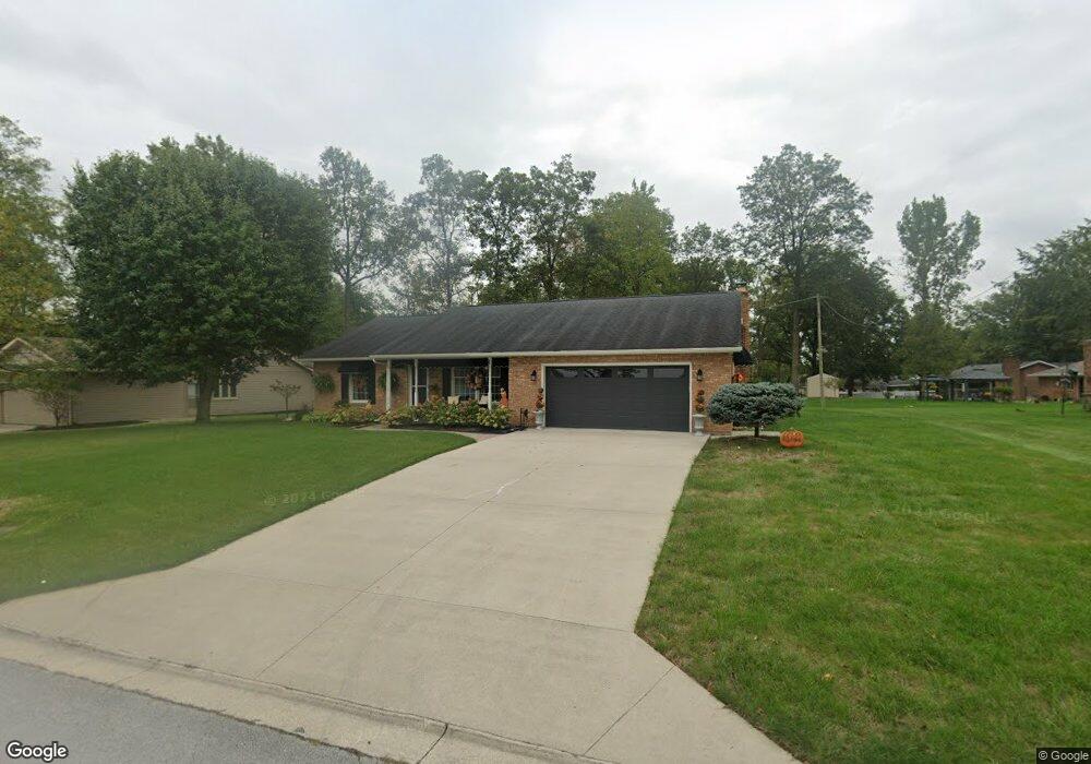
1026 Loretta Place Lima, OH 45805
Westgate NeighborhoodEstimated Value: $163,000 - $211,000
3
Beds
2
Baths
1,312
Sq Ft
$149/Sq Ft
Est. Value
About This Home
This home is located at 1026 Loretta Place, Lima, OH 45805 and is currently estimated at $195,316, approximately $148 per square foot. 1026 Loretta Place is a home located in Allen County with nearby schools including Heritage Elementary School, Lima West Middle School, and Lima North Middle School.
Ownership History
Date
Name
Owned For
Owner Type
Purchase Details
Closed on
Aug 16, 2019
Sold by
Simons Carol and Stemen Linda
Bought by
Shearer Geraldine and Gallagher Natalie
Current Estimated Value
Purchase Details
Closed on
Jun 8, 1988
Bought by
Goes James Francis
Create a Home Valuation Report for This Property
The Home Valuation Report is an in-depth analysis detailing your home's value as well as a comparison with similar homes in the area
Home Values in the Area
Average Home Value in this Area
Purchase History
| Date | Buyer | Sale Price | Title Company |
|---|---|---|---|
| Shearer Geraldine | $120,000 | None Available | |
| Goes James Francis | $85,000 | -- |
Source: Public Records
Tax History Compared to Growth
Tax History
| Year | Tax Paid | Tax Assessment Tax Assessment Total Assessment is a certain percentage of the fair market value that is determined by local assessors to be the total taxable value of land and additions on the property. | Land | Improvement |
|---|---|---|---|---|
| 2024 | $1,890 | $63,110 | $9,310 | $53,800 |
| 2023 | $1,505 | $45,750 | $6,760 | $38,990 |
| 2022 | $1,530 | $45,750 | $6,760 | $38,990 |
| 2021 | $1,622 | $45,750 | $6,760 | $38,990 |
| 2020 | $1,557 | $40,180 | $6,440 | $33,740 |
| 2019 | $1,557 | $40,180 | $6,440 | $33,740 |
| 2018 | $1,509 | $40,180 | $6,440 | $33,740 |
| 2017 | $1,486 | $38,570 | $6,440 | $32,130 |
| 2016 | $1,500 | $38,570 | $6,440 | $32,130 |
| 2015 | $1,247 | $38,570 | $6,440 | $32,130 |
| 2014 | $1,247 | $32,980 | $6,830 | $26,150 |
| 2013 | $1,213 | $32,980 | $6,830 | $26,150 |
Source: Public Records
Map
Nearby Homes
- 918 Cornell Dr
- 1719 Latham Ave
- 102 Charwood Dr
- 1113 Crestwood Dr
- 621 Fairfield Dr
- 1753 Leland Ave
- 858 Mackenzie Dr
- 1710 Camp Ave
- 1580 W Robb Ave
- 1517 Allentown Rd
- 1730 Homeward Ave
- 1206 Rice Ave
- 2100 University Blvd
- 1703 W Wayne St
- 514 N Cable Rd
- 0 Sherman Ave
- 1744 Homeward Ave
- 00 Homeward Ave
- 1120 Richie Ave
- 1023 Leland Ave