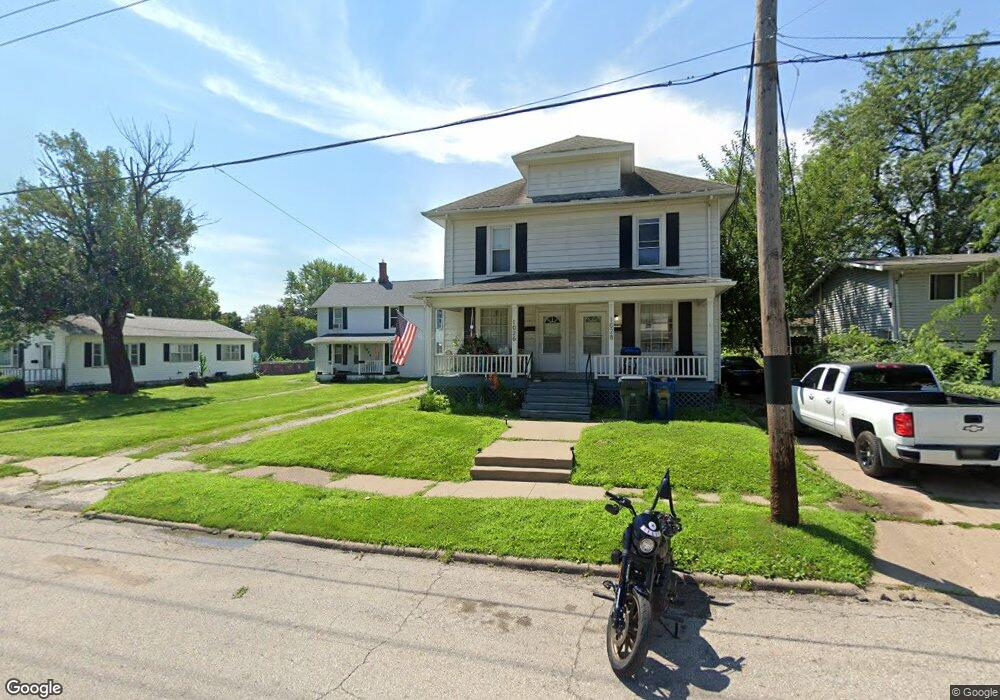
1026 Newell Ave Muscatine, IA 52761
Estimated Value: $137,000 - $206,000
6
Beds
2
Baths
2,449
Sq Ft
$73/Sq Ft
Est. Value
About This Home
This home is located at 1026 Newell Ave, Muscatine, IA 52761 and is currently estimated at $178,246, approximately $72 per square foot. 1026 Newell Ave is a home located in Muscatine County with nearby schools including McKinley Elementary School, Susan Clark Junior High School, and Muscatine High School.
Ownership History
Date
Name
Owned For
Owner Type
Purchase Details
Closed on
May 8, 2024
Sold by
Trust Nevertheless and Hungate Pamela M
Bought by
Castillo Kim A and Castillo Hector F
Current Estimated Value
Home Financials for this Owner
Home Financials are based on the most recent Mortgage that was taken out on this home.
Original Mortgage
$145,000
Interest Rate
7.02%
Mortgage Type
Credit Line Revolving
Purchase Details
Closed on
Apr 27, 2017
Sold by
H Marie Hungate Estate
Bought by
In Trust Nevertheless
Create a Home Valuation Report for This Property
The Home Valuation Report is an in-depth analysis detailing your home's value as well as a comparison with similar homes in the area
Home Values in the Area
Average Home Value in this Area
Purchase History
| Date | Buyer | Sale Price | Title Company |
|---|---|---|---|
| Castillo Kim A | $100,000 | None Listed On Document | |
| In Trust Nevertheless | -- | None Available |
Source: Public Records
Mortgage History
| Date | Status | Borrower | Loan Amount |
|---|---|---|---|
| Previous Owner | Castillo Kim A | $145,000 |
Source: Public Records
Tax History Compared to Growth
Tax History
| Year | Tax Paid | Tax Assessment Tax Assessment Total Assessment is a certain percentage of the fair market value that is determined by local assessors to be the total taxable value of land and additions on the property. | Land | Improvement |
|---|---|---|---|---|
| 2025 | $3,352 | $114,010 | $15,680 | $98,330 |
| 2024 | $3,352 | $184,920 | $15,680 | $169,240 |
| 2023 | $3,190 | $183,231 | $15,677 | $167,554 |
| 2022 | $2,870 | $144,650 | $14,790 | $129,860 |
| 2021 | $2,870 | $140,620 | $14,790 | $125,830 |
| 2020 | $2,834 | $141,550 | $14,790 | $126,760 |
| 2019 | $2,750 | $124,520 | $0 | $0 |
| 2018 | $2,710 | $124,330 | $0 | $0 |
| 2017 | $2,710 | $117,890 | $0 | $0 |
| 2016 | $2,666 | $117,890 | $0 | $0 |
| 2015 | $2,666 | $105,540 | $0 | $0 |
| 2014 | $2,402 | $105,540 | $0 | $0 |
Source: Public Records
Map
Nearby Homes
- 2207 Lucas St
- 208 Fletcher Ave
- 1143 Logan St
- 0 High Street Parcel
- 2109 Americana Ave
- 1619 Devitt Ave
- 1603 Lucas St
- 1903 Hershey Ave
- 1827 Hershey Ave
- 111 Gilbert St
- PARCEL ID 0834280023 Dillaway St
- 1617 W Acre Dr
- 836 Newell Ave
- 0 Parcel 1302108019 (Busch St)
- 1506 Buell St
- 602 W Fulliam Ave
- 518 Roscoe Ave
- 1416 Duncan Dr
- 511 W 7th St
- LOTS 30-34 Evans St
- 1024 Newell Ave
- 1032 Newell Ave
- 1020 Newell Ave
- 2215 Lucas St
- 2211 Lucas St
- 2219 Lucas St
- 2223 Lucas St
- 1008 Newell Ave
- 1031 Newell Ave
- 1023 Newell Ave
- 2227 Lucas St
- 1033 Newell Ave
- 1021 Newell Ave
- 2203 Lucas St
- 1006 Newell Ave
- 1006 Newell Ave
- 2210 Lucas St
- 2201 Lucas St
- 2229 Lucas St
- 1019 Newell Ave