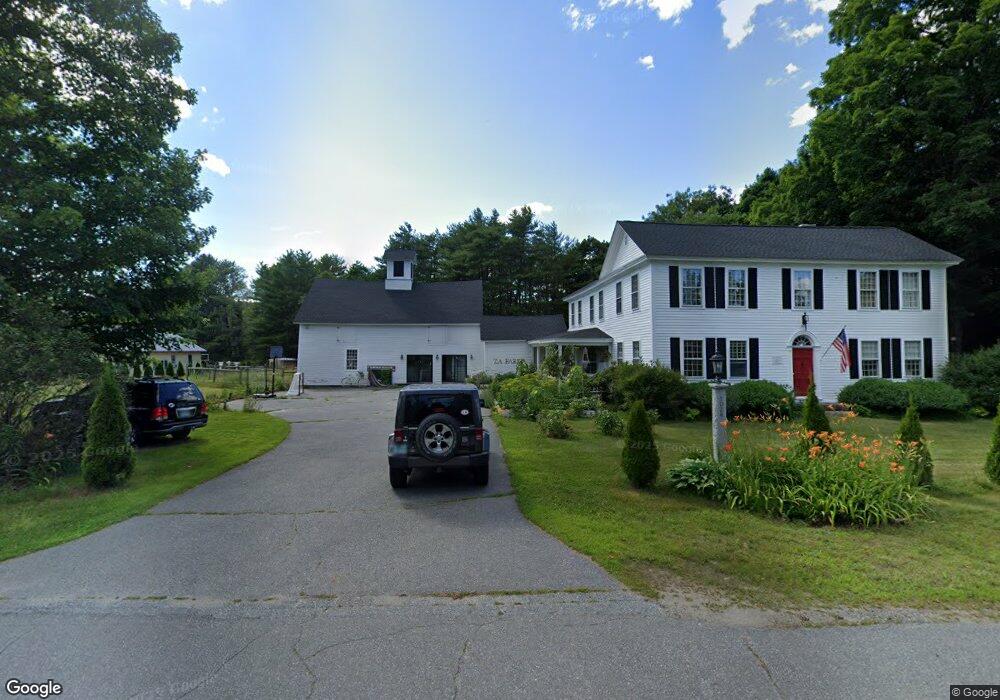
1026 Route 12a Plainfield, NH 03781
Estimated Value: $597,000 - $782,000
4
Beds
3
Baths
3,739
Sq Ft
$181/Sq Ft
Est. Value
About This Home
This home is located at 1026 Route 12a, Plainfield, NH 03781 and is currently estimated at $677,419, approximately $181 per square foot. 1026 Route 12a is a home located in Sullivan County with nearby schools including Plainfield Elementary School, Lebanon High School, and Estabrook Christian School.
Ownership History
Date
Name
Owned For
Owner Type
Purchase Details
Closed on
Sep 2, 2020
Sold by
Horne Mark H and Horne Sandra R
Bought by
Gruntmanis Ugis and Gruntmane Tereze
Current Estimated Value
Home Financials for this Owner
Home Financials are based on the most recent Mortgage that was taken out on this home.
Original Mortgage
$248,000
Outstanding Balance
$220,488
Interest Rate
3%
Mortgage Type
New Conventional
Estimated Equity
$456,931
Purchase Details
Closed on
Dec 20, 2005
Sold by
Gmac Global Relocation
Bought by
Horne Mark H and Horne Sandra R
Home Financials for this Owner
Home Financials are based on the most recent Mortgage that was taken out on this home.
Original Mortgage
$472,500
Interest Rate
6.34%
Mortgage Type
Purchase Money Mortgage
Create a Home Valuation Report for This Property
The Home Valuation Report is an in-depth analysis detailing your home's value as well as a comparison with similar homes in the area
Home Values in the Area
Average Home Value in this Area
Purchase History
| Date | Buyer | Sale Price | Title Company |
|---|---|---|---|
| Gruntmanis Ugis | $310,000 | None Available | |
| Horne Mark H | $525,000 | -- |
Source: Public Records
Mortgage History
| Date | Status | Borrower | Loan Amount |
|---|---|---|---|
| Open | Gruntmanis Ugis | $248,000 | |
| Previous Owner | Horne Mark H | $472,500 |
Source: Public Records
Tax History Compared to Growth
Tax History
| Year | Tax Paid | Tax Assessment Tax Assessment Total Assessment is a certain percentage of the fair market value that is determined by local assessors to be the total taxable value of land and additions on the property. | Land | Improvement |
|---|---|---|---|---|
| 2023 | $9,578 | $608,100 | $159,000 | $449,100 |
| 2022 | $7,435 | $298,600 | $79,500 | $219,100 |
| 2021 | $7,880 | $296,800 | $79,500 | $217,300 |
| 2020 | $9,408 | $370,400 | $88,500 | $281,900 |
| 2019 | $9,630 | $370,400 | $88,500 | $281,900 |
| 2018 | $734 | $370,400 | $88,500 | $281,900 |
| 2017 | $10,023 | $354,800 | $81,300 | $273,500 |
| 2016 | $10,059 | $354,800 | $81,300 | $273,500 |
| 2015 | $9,668 | $354,800 | $81,300 | $273,500 |
Source: Public Records
Map
Nearby Homes
- 1118 New Hampshire 12a
- 846 New Hampshire 12a
- 0 Freeman Rd Unit 22
- 00 Nh Route 12a Unit 7
- 1507 Route 12a
- 6 Blodgett Ln
- 16 Nh Route 12a
- 149 Old County Rd
- 1041 Stage Rd
- 56 Mount Hunger Rd
- 10 Bischoff Ln
- 161 Saint Gaudens Rd
- 14 Summarsell Dr Unit 16
- 89 Route 12
- 22 King Dr
- 40 Mill St
- 3 MacE Hill Rd
- 282 Penniman Rd
- 58 Morningside Dr
- 286 Ladieu Rd
- 1026 Route 12a
- 1030 Route 12a
- 1032 Route 12a
- 1042 Route 12a
- 1001 New Hampshire 12a
- 988 Route 12a
- 1027 Route 12a
- 1027 New Hampshire 12a
- 1031 Route 12a
- 986 Route 12a
- 1050 Route 12a
- 1 Whitney Rd
- 985 Route 12a
- 985 Route 12a
- 00 New Hampshire 12a
- 0 New Hampshire 12a
- 1055 New Hampshire 12a
- 1055 Route 12a
- 1059 Route 12a
- 1059 New Hampshire 12a