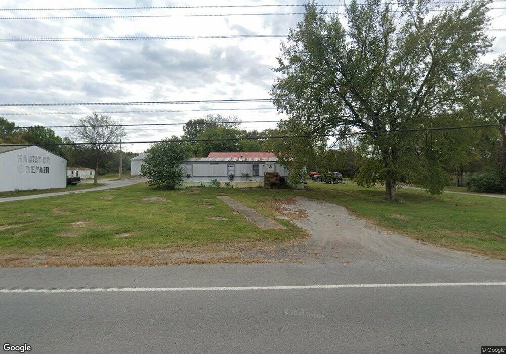
1027 Highway 64 W Shelbyville, TN 37160
Estimated Value: $228,634 - $315,000
--
Bed
1
Bath
1,215
Sq Ft
$235/Sq Ft
Est. Value
About This Home
This home is located at 1027 Highway 64 W, Shelbyville, TN 37160 and is currently estimated at $285,159, approximately $234 per square foot. 1027 Highway 64 W is a home located in Bedford County with nearby schools including South Side Elementary School, Harris Middle School, and Christian Chapel Academy.
Ownership History
Date
Name
Owned For
Owner Type
Purchase Details
Closed on
Aug 14, 2001
Sold by
Hawthorne Kenneth
Bought by
Parsons Ryan K and Parsons Melissa
Current Estimated Value
Purchase Details
Closed on
Aug 3, 2001
Bought by
Parsons Ryan K & Melis Sa S
Purchase Details
Closed on
Mar 27, 1991
Bought by
Hawthorne Ken
Purchase Details
Closed on
Oct 1, 1987
Bought by
Miller Mike T
Purchase Details
Closed on
Mar 21, 1987
Bought by
Freeman Roy and Freeman Katie
Purchase Details
Closed on
Jul 22, 1986
Bought by
Urban Terry Lee & Susan L
Create a Home Valuation Report for This Property
The Home Valuation Report is an in-depth analysis detailing your home's value as well as a comparison with similar homes in the area
Home Values in the Area
Average Home Value in this Area
Purchase History
| Date | Buyer | Sale Price | Title Company |
|---|---|---|---|
| Parsons Ryan K | $147,000 | -- | |
| Parsons Ryan K & Melis Sa S | $147,000 | -- | |
| Hawthorne Ken | -- | -- | |
| Miller Mike T | -- | -- | |
| Freeman Roy | -- | -- | |
| Urban Terry Lee & Susan L | -- | -- |
Source: Public Records
Tax History Compared to Growth
Tax History
| Year | Tax Paid | Tax Assessment Tax Assessment Total Assessment is a certain percentage of the fair market value that is determined by local assessors to be the total taxable value of land and additions on the property. | Land | Improvement |
|---|---|---|---|---|
| 2025 | $989 | $42,525 | $0 | $0 |
| 2024 | $989 | $42,525 | $9,900 | $32,625 |
| 2023 | $989 | $42,525 | $9,900 | $32,625 |
| 2022 | $989 | $42,525 | $9,900 | $32,625 |
| 2021 | $836 | $42,525 | $9,900 | $32,625 |
| 2020 | $1,165 | $42,525 | $9,900 | $32,625 |
| 2019 | $1,165 | $43,800 | $13,840 | $29,960 |
| 2018 | $1,121 | $43,800 | $13,840 | $29,960 |
| 2017 | $1,121 | $43,800 | $13,840 | $29,960 |
| 2014 | $614 | $27,066 | $0 | $0 |
Source: Public Records
Map
Nearby Homes
- 127 Doak St
- 102 Doak St
- 302 Graydon St
- 107 Stonebrook Dr
- 116 Stonebrook Dr
- 0 Hilltop Dr
- 125 Burrum Dr
- 823 Brookhaven Cir
- 103 Davis St
- 112 N Linda Dr
- 702 Adams Dr
- 600 Lewis Ave
- 349 Naron Rd
- 112 August Way
- 508 Lewis Ave
- 611 Coble Cir
- 310 Crest Dr
- 201 Shelbyville Mills Rd
- 1106 Highway 130 W
- 485 Naron Rd
- 0 Highway 64 W Unit 1964788
- 2 Highway 64 W
- 1 Highway 64 W
- 3 Highway 64 W
- 0 Highway 64 W
- 0 Highway 64 W Unit RTC2748383
- 0 Highway 64 W Unit RTC2578242
- 0 Highway 64 W Unit RTC1698245
- 0 Highway 64 W Unit RTC1532093
- 0 Highway 64 W Unit RTC2529702
- 0 Highway 64 W Unit RTC1993744
- 0 Highway 64 W Unit RTC2400540
- 0 Highway 64 W Unit RTC2169213
- 0 Highway 64 W Unit RTC2237957
- 0 Highway 64 W Unit 2222989
- 0 Highway 64 W Unit 2172210
- 0 Highway 64 W Unit 2151153
- 0 Highway 64 W Unit 2038855
- 0 Highway 64 W Unit 2009754
- 0 Highway 64 W Unit 1999361