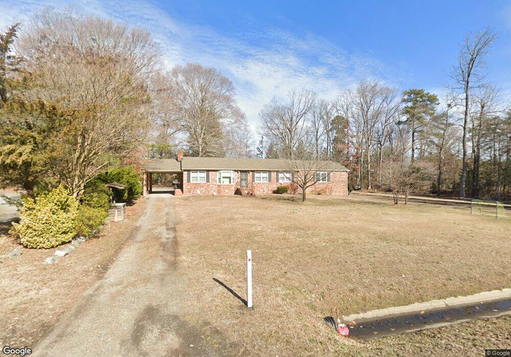
10282 Lewistown Rd Ashland, VA 23005
Estimated Value: $342,000 - $380,888
3
Beds
3
Baths
1,872
Sq Ft
$197/Sq Ft
Est. Value
About This Home
This home is located at 10282 Lewistown Rd, Ashland, VA 23005 and is currently estimated at $367,972, approximately $196 per square foot. 10282 Lewistown Rd is a home located in Hanover County with nearby schools including Elmont Elementary School, Liberty Middle School, and Patrick Henry High School.
Ownership History
Date
Name
Owned For
Owner Type
Purchase Details
Closed on
Dec 9, 2010
Sold by
Glasscock Karl David
Bought by
Ingle Vernon E
Current Estimated Value
Home Financials for this Owner
Home Financials are based on the most recent Mortgage that was taken out on this home.
Original Mortgage
$131,250
Outstanding Balance
$86,803
Interest Rate
4.24%
Mortgage Type
New Conventional
Estimated Equity
$281,169
Purchase Details
Closed on
Aug 17, 2005
Sold by
Richardson Nora G
Bought by
Glascock Karl David
Home Financials for this Owner
Home Financials are based on the most recent Mortgage that was taken out on this home.
Original Mortgage
$198,927
Interest Rate
5.68%
Mortgage Type
FHA
Create a Home Valuation Report for This Property
The Home Valuation Report is an in-depth analysis detailing your home's value as well as a comparison with similar homes in the area
Home Values in the Area
Average Home Value in this Area
Purchase History
| Date | Buyer | Sale Price | Title Company |
|---|---|---|---|
| Ingle Vernon E | $175,000 | -- | |
| Glascock Karl David | $200,500 | -- |
Source: Public Records
Mortgage History
| Date | Status | Borrower | Loan Amount |
|---|---|---|---|
| Open | Ingle Vernon E | $131,250 | |
| Previous Owner | Glascock Karl David | $198,927 |
Source: Public Records
Tax History Compared to Growth
Tax History
| Year | Tax Paid | Tax Assessment Tax Assessment Total Assessment is a certain percentage of the fair market value that is determined by local assessors to be the total taxable value of land and additions on the property. | Land | Improvement |
|---|---|---|---|---|
| 2025 | $2,709 | $334,500 | $73,700 | $260,800 |
| 2024 | $2,709 | $334,500 | $73,700 | $260,800 |
| 2023 | $2,242 | $291,200 | $69,200 | $222,000 |
| 2022 | $2,053 | $253,500 | $64,700 | $188,800 |
| 2021 | $1,735 | $214,200 | $55,700 | $158,500 |
| 2020 | $1,735 | $214,200 | $55,700 | $158,500 |
| 2019 | $1,442 | $199,600 | $55,700 | $143,900 |
| 2018 | $1,442 | $178,000 | $51,300 | $126,700 |
| 2017 | $1,442 | $178,000 | $51,300 | $126,700 |
| 2016 | $1,442 | $178,000 | $51,300 | $126,700 |
| 2015 | $1,350 | $166,700 | $46,800 | $119,900 |
| 2014 | $1,350 | $166,700 | $46,800 | $119,900 |
Source: Public Records
Map
Nearby Homes
- 10036 Johnson Town Rd
- MM Taft (Lee Parcel A-1) Rd
- 2051 Asher (Lot 1) Dr
- 10509 Lewistown Rd
- 000 Old Telegraph Rd
- 11035 Old Telegraph Rd
- 10439 Ashcake Rd
- 11497 Haltonshire Way
- 12200 Campbell Creek Rd
- 10521 Stony Bluff Dr Unit 201
- 11264 Cobbs Rd
- 10525 Stony Bluff Dr Unit 202
- 10525 Stony Bluff Dr Unit 205
- 10525 Stony Bluff Dr Unit 201
- 10525 Stony Bluff Dr Unit 107
- 10525 Stony Bluff Dr Unit 101
- 10525 Stony Bluff Dr Unit 102
- 10525 Stony Bluff Dr Unit 207
- 10525 Stony Bluff Dr Unit 203
- 10525 Stony Bluff Dr Unit 206
- 10290 Lewistown Rd
- 10268 Lewistown Rd
- 10277 Lewistown Rd
- 10285 Lewistown Rd
- 10293 Lewistown Rd
- 10298 Lewistown Rd
- 10301 Lewistown Rd
- 11355 Carters Heights Rd
- 10306 Lewistown Rd
- 10309 Lewistown Rd
- 11341 Carters Heights Rd
- 11375 N Lakeridge Pkwy
- 0000 Lewistown Rd
- 10318 Lewistown Rd
- 10317 Lewistown Rd
- 11333 Carters Heights Rd
- 11296 Knox Dr
- 11657 Lakeridge Pkwy Unit G
- 11657 Lakeridge Pkwy
- 11325 Carters Heights Rd