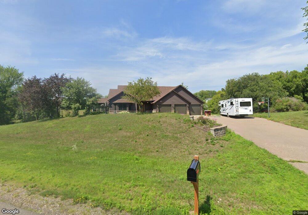
10288 Barnes Way Inver Grove Heights, MN 55077
Estimated Value: $734,047 - $803,000
4
Beds
4
Baths
2,112
Sq Ft
$365/Sq Ft
Est. Value
About This Home
This home is located at 10288 Barnes Way, Inver Grove Heights, MN 55077 and is currently estimated at $770,762, approximately $364 per square foot. 10288 Barnes Way is a home located in Dakota County with nearby schools including Red Pine Elementary School, Rosemount Middle School, and Rosemount Senior High School.
Ownership History
Date
Name
Owned For
Owner Type
Purchase Details
Closed on
Jan 11, 2017
Sold by
Bjorgaard George E and Bjorgaard Idelle J
Bought by
Wise Victoria L and Wise Joshua J
Current Estimated Value
Home Financials for this Owner
Home Financials are based on the most recent Mortgage that was taken out on this home.
Original Mortgage
$408,500
Outstanding Balance
$338,546
Interest Rate
4.32%
Mortgage Type
New Conventional
Estimated Equity
$432,216
Create a Home Valuation Report for This Property
The Home Valuation Report is an in-depth analysis detailing your home's value as well as a comparison with similar homes in the area
Home Values in the Area
Average Home Value in this Area
Purchase History
| Date | Buyer | Sale Price | Title Company |
|---|---|---|---|
| Wise Victoria L | $430,000 | Edina Realty Title Inc |
Source: Public Records
Mortgage History
| Date | Status | Borrower | Loan Amount |
|---|---|---|---|
| Open | Wise Victoria L | $408,500 |
Source: Public Records
Tax History Compared to Growth
Tax History
| Year | Tax Paid | Tax Assessment Tax Assessment Total Assessment is a certain percentage of the fair market value that is determined by local assessors to be the total taxable value of land and additions on the property. | Land | Improvement |
|---|---|---|---|---|
| 2024 | $7,984 | $637,300 | $229,300 | $408,000 |
| 2023 | $7,984 | $615,900 | $223,400 | $392,500 |
| 2022 | $7,240 | $611,900 | $223,200 | $388,700 |
| 2021 | $6,642 | $554,300 | $194,100 | $360,200 |
| 2020 | $6,418 | $510,900 | $184,800 | $326,100 |
| 2019 | $5,977 | $482,500 | $176,000 | $306,500 |
| 2018 | $5,558 | $461,500 | $167,700 | $293,800 |
| 2017 | $5,517 | $428,700 | $159,700 | $269,000 |
| 2016 | $5,469 | $409,500 | $152,100 | $257,400 |
| 2015 | $5,104 | $408,788 | $148,251 | $260,537 |
| 2014 | -- | $388,950 | $142,151 | $246,799 |
| 2013 | -- | $367,695 | $131,935 | $235,760 |
Source: Public Records
Map
Nearby Homes
- 2324 99th St E
- 9649-9665 Cedarwood Ct
- 10064 Adam Ave
- 11025 Courthouse Blvd
- 10684 Alameda Ave
- 8904 Brunswick Path Unit 2104
- 8789 Branson Dr Unit 72
- TBd Cahill Blvd Blvd
- 8816 Brunell Way Unit 404
- 9380 Aladin Trail
- 2853 87th St E Unit 29
- 8755 Benson Way Unit 101
- 10612 Alison Way
- 8827 Coffman Path
- 8916 Coffman Path
- 10787 Alison Way
- 4525 Alicia Dr
- 7924 Barbara Ave
- 7910 Banks Path
- 4168 Countryview Dr
- 10170 Barnes Way
- 10269 Barnes Way
- 10305 Barnes Way
- 10362 Barnes Way
- 10333 Barnes Way
- 10195 Barnes Way
- 10189 Barnes Way
- 10199 Barnes Way
- 10211 Barnes Ave E
- 1985 102nd St E
- 10211 Barnes Way
- 10211 Barnes Way
- 10211 10211 Barnes-Avenue-
- 94 Po Box
- 10185 Barnes Ave
- 10471 Barnes Ave
- 10399 Barnes Way
- 10409 Barnes Way
- 2160 100th St E
- 1865 102nd St E