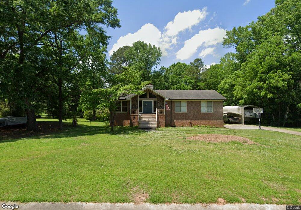
103 Hackberry Ln Maylene, AL 35114
Estimated Value: $241,000 - $308,261
3
Beds
2
Baths
2,016
Sq Ft
$130/Sq Ft
Est. Value
About This Home
This home is located at 103 Hackberry Ln, Maylene, AL 35114 and is currently estimated at $262,065, approximately $129 per square foot. 103 Hackberry Ln is a home located in Shelby County with nearby schools including Thompson Intermediate School, Thompson Middle School, and Thompson High School.
Ownership History
Date
Name
Owned For
Owner Type
Purchase Details
Closed on
Sep 15, 2011
Sold by
Federal Home Loan Mortgage Corporation
Bought by
Pierce Jeremy L
Current Estimated Value
Home Financials for this Owner
Home Financials are based on the most recent Mortgage that was taken out on this home.
Original Mortgage
$95,000
Interest Rate
4.16%
Mortgage Type
New Conventional
Purchase Details
Closed on
May 22, 2006
Sold by
Finch Borden H and Finch Mary E
Bought by
Alexander Tandy Lee
Home Financials for this Owner
Home Financials are based on the most recent Mortgage that was taken out on this home.
Original Mortgage
$123,900
Interest Rate
6.5%
Mortgage Type
Unknown
Create a Home Valuation Report for This Property
The Home Valuation Report is an in-depth analysis detailing your home's value as well as a comparison with similar homes in the area
Home Values in the Area
Average Home Value in this Area
Purchase History
| Date | Buyer | Sale Price | Title Company |
|---|---|---|---|
| Pierce Jeremy L | $100,001 | None Available | |
| Alexander Tandy Lee | $154,900 | None Available |
Source: Public Records
Mortgage History
| Date | Status | Borrower | Loan Amount |
|---|---|---|---|
| Previous Owner | Pierce Jeremy L | $95,000 | |
| Previous Owner | Alexander Tandy Lee | $123,900 |
Source: Public Records
Tax History
| Year | Tax Paid | Tax Assessment Tax Assessment Total Assessment is a certain percentage of the fair market value that is determined by local assessors to be the total taxable value of land and additions on the property. | Land | Improvement |
|---|---|---|---|---|
| 2024 | $1,440 | $26,660 | $0 | $0 |
| 2023 | $1,292 | $24,680 | $0 | $0 |
| 2022 | $1,192 | $22,840 | $0 | $0 |
| 2021 | $1,067 | $20,520 | $0 | $0 |
| 2020 | $1,006 | $19,380 | $0 | $0 |
| 2019 | $949 | $18,340 | $0 | $0 |
| 2017 | $821 | $15,960 | $0 | $0 |
| 2015 | $784 | $15,280 | $0 | $0 |
| 2014 | $765 | $14,920 | $0 | $0 |
Source: Public Records
Map
Nearby Homes
- 1315 Yellowleaf Cir
- 549 Ramsgate Dr
- 328 Sweet Leaf Dr
- 545 Ramsgate Dr
- 544 Ramsgate Dr
- 217 Kensington Ln
- 305 Cedar Grove Ct
- 309 Cedar Grove Ct
- 312 Cornwall Dr
- 236 Queens Gate
- 1138 Eagle Dr
- 501 Ramsgate Dr
- 120 Sterling Gate Dr
- 537 Ramsgate Dr
- 208 Queens Gate
- 280 Cedar Grove Pkwy
- 306 Mayfair Cir
- 316 Sterling Manor Cir
- 120 Mayfair Park
- 116 Palm Dr
- 105 Hackberry Ln
- 101 Hackberry Ln
- 109 Hackberry Ln
- 100 Hackberry Ln
- 104 Hackberry Ln
- 209 Redwood Dr
- 113 Hackberry Ln
- 212 Redwood Dr
- 108 Hackberry Ln
- 208 Redwood Dr
- 112 Hackberry Ln
- 117 Hackberry Ln
- 219 Redwood Dr
- 205 Redwood Dr
- 205 Redwood Dr
- 204 Redwood Dr
- 129 Oak St
- 133 Oak St
- 201 Redwood Dr
- 221 Redwood Dr
Your Personal Tour Guide
Ask me questions while you tour the home.