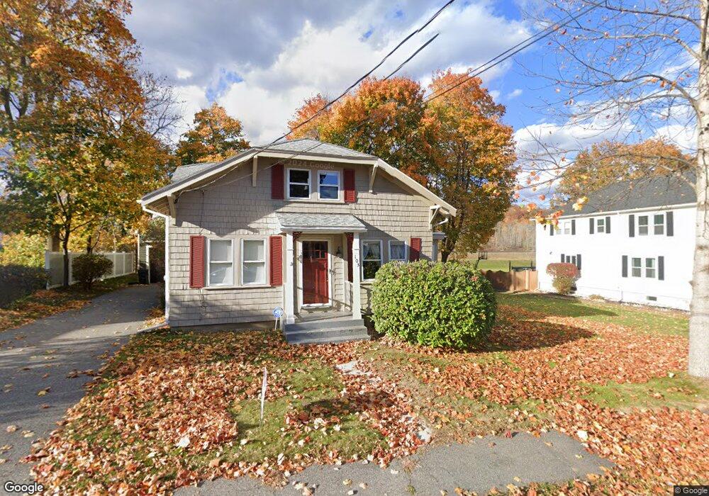
103 High St Amesbury, MA 01913
Estimated Value: $514,000 - $702,000
4
Beds
2
Baths
1,638
Sq Ft
$375/Sq Ft
Est. Value
About This Home
This home is located at 103 High St, Amesbury, MA 01913 and is currently estimated at $613,858, approximately $374 per square foot. 103 High St is a home located in Essex County with nearby schools including Amesbury High School and Amesbury Seventh-Day Adventist School.
Ownership History
Date
Name
Owned For
Owner Type
Purchase Details
Closed on
May 27, 2025
Sold by
Vigneault Joseph M
Bought by
Vigneault Lt and Vigneault
Current Estimated Value
Purchase Details
Closed on
Oct 16, 2023
Sold by
Vigneault Joseph M and Vigneault Valerie M
Bought by
Vigneault Joseph M
Create a Home Valuation Report for This Property
The Home Valuation Report is an in-depth analysis detailing your home's value as well as a comparison with similar homes in the area
Home Values in the Area
Average Home Value in this Area
Purchase History
| Date | Buyer | Sale Price | Title Company |
|---|---|---|---|
| Vigneault Lt | -- | None Available | |
| Vigneault Lt | -- | None Available | |
| Vigneault Lt | -- | None Available | |
| Vigneault Joseph M | -- | None Available | |
| Vigneault Joseph M | -- | None Available | |
| Vigneault Joseph M | -- | None Available |
Source: Public Records
Tax History Compared to Growth
Tax History
| Year | Tax Paid | Tax Assessment Tax Assessment Total Assessment is a certain percentage of the fair market value that is determined by local assessors to be the total taxable value of land and additions on the property. | Land | Improvement |
|---|---|---|---|---|
| 2025 | $7,104 | $464,300 | $209,000 | $255,300 |
| 2024 | $6,846 | $437,700 | $197,100 | $240,600 |
| 2023 | $6,732 | $412,000 | $171,400 | $240,600 |
| 2022 | $6,655 | $376,200 | $149,000 | $227,200 |
| 2021 | $6,260 | $343,000 | $115,100 | $227,900 |
| 2020 | $5,618 | $327,000 | $110,700 | $216,300 |
| 2019 | $5,629 | $306,400 | $110,700 | $195,700 |
| 2018 | $5,551 | $292,300 | $105,500 | $186,800 |
| 2017 | $5,105 | $255,900 | $105,500 | $150,400 |
| 2016 | $4,894 | $241,300 | $105,500 | $135,800 |
| 2015 | $4,905 | $238,800 | $105,500 | $133,300 |
| 2014 | $4,626 | $220,600 | $105,500 | $115,100 |
Source: Public Records
Map
Nearby Homes
- 93 Friend St
- 48 Orchard St
- 4 Winter St
- 37 Millyard Unit 204
- 4 Larnard Ct
- 31 Whitter Meadows Dr Unit 31
- 13 High St Unit 2
- 43 Aubin St Unit 43
- 3 Arlington St
- 188 Lions Mouth Rd
- 5 Moncrief St Unit 5
- 102 Market St
- 101 Market St Unit B
- 101 Market St Unit A
- 105 Market St Unit B
- 16 Glen Devin St
- 25 Cedar St Unit 4
- 25 Cedar St Unit 14
- 25 Cedar St Unit 7
- 49 W Greenwood St