


103 Irene Way Stevensville, MD 21666
Estimated payment $13,423/month
Highlights
- Marina
- Marina View
- Access to Tidal Water
- Matapeake Elementary School Rated A-
- Home fronts navigable water
- Fitness Center
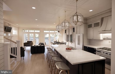
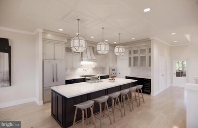
About This Home
Welcome to Sunset Wharf, an exclusive 28 unit duplex development nestled in the serene Bay Bridge Marina. Embrace waterside living at its finest with stunning views, modern amenities, and the charm of a close-knit community. Each duplex is meticulously designed to offer spacious, open-concept layouts that blend modern elegance with everyday comfort. Enjoy breathtaking views of the Chesapeake Bay through expansive windows that fill your home with natural light. High-end finishes, gourmet kitchens, and luxurious master suites create an ambiance of sophistication and tranquility. Private outdoor spaces provide the perfect setting for relaxation or entertaining guests. With a variety of floor plans to suit your lifestyle, the units at Sunset Wharf promise an unparalleled living experience in a vibrant, coastal community. Enjoy easy access to marina facilities, scenic walking trails, and vibrant local dining, walking distance to Libbey's Coastal Kitchen & Cocktails and Knoxie's Table. At Sunset Wharf, experience the perfect blend of tranquility and convenience, making it the ideal place to call home. Discover your paradise by the bay today!
Listing Agent
(410) 279-9476 brad.kappel@sothebysrealty.com TTR Sotheby's International Realty Listed on: 12/08/2025

Co-Listing Agent
(410) 703-3403 joe@waterfronthomes.org TTR Sotheby's International Realty License #643757
Townhouse Details
Home Type
- Townhome
Lot Details
- 4,356 Sq Ft Lot
- Home fronts navigable water
- Extensive Hardscape
- Property is in excellent condition
HOA Fees
- $800 Monthly HOA Fees
Parking
- 2 Car Direct Access Garage
- 2 Driveway Spaces
- Rear-Facing Garage
- Garage Door Opener
Property Views
- Marina
- Bay
- Scenic Vista
Home Design
- New Construction
- Semi-Detached or Twin Home
- Coastal Architecture
Interior Spaces
- 3,280 Sq Ft Home
- Property has 3 Levels
- 1 Elevator
- Open Floorplan
- Crown Molding
- Ceiling Fan
- Recessed Lighting
- 2 Fireplaces
- Gas Fireplace
- Family Room Off Kitchen
- Dining Area
Kitchen
- Gourmet Kitchen
- Gas Oven or Range
- Range Hood
- Built-In Microwave
- Dishwasher
- Stainless Steel Appliances
- Kitchen Island
- Upgraded Countertops
- Disposal
Flooring
- Ceramic Tile
- Luxury Vinyl Plank Tile
Bedrooms and Bathrooms
- En-Suite Bathroom
- Walk-In Closet
Laundry
- Laundry in unit
- Dryer
- Washer
Home Security
Accessible Home Design
- Accessible Elevator Installed
Outdoor Features
- Outdoor Shower
- Access to Tidal Water
- Water Access
- Property near a bay
- Multiple Balconies
- Patio
- Exterior Lighting
Utilities
- Forced Air Heating and Cooling System
- Heat Pump System
- Heating System Powered By Owned Propane
- Vented Exhaust Fan
- Programmable Thermostat
- Electric Water Heater
Listing and Financial Details
- $1,998 Front Foot Fee per year
Community Details
Overview
- Bay Bridge Marina Subdivision
Amenities
- Common Area
- Community Center
Recreation
- Marina
- Fitness Center
- Community Pool
Pet Policy
- Pets Allowed
Security
- Carbon Monoxide Detectors
- Fire and Smoke Detector
- Fire Sprinkler System
Map
Home Values in the Area
Average Home Value in this Area
Tax History
| Year | Tax Paid | Tax Assessment Tax Assessment Total Assessment is a certain percentage of the fair market value that is determined by local assessors to be the total taxable value of land and additions on the property. | Land | Improvement |
|---|---|---|---|---|
| 2025 | $3,132 | $332,533 | $0 | $0 |
| 2024 | $2,898 | $307,667 | $0 | $0 |
| 2023 | $2,664 | $282,800 | $161,800 | $121,000 |
| 2022 | $2,627 | $278,833 | $0 | $0 |
| 2021 | $2,636 | $274,867 | $0 | $0 |
| 2020 | $2,598 | $270,900 | $161,800 | $109,100 |
| 2019 | $2,513 | $261,967 | $0 | $0 |
| 2018 | $2,427 | $253,033 | $0 | $0 |
| 2017 | $2,341 | $244,100 | $0 | $0 |
| 2016 | -- | $238,267 | $0 | $0 |
| 2015 | $2,716 | $232,433 | $0 | $0 |
| 2014 | $2,716 | $226,600 | $0 | $0 |
Property History
| Date | Event | Price | List to Sale | Price per Sq Ft |
|---|---|---|---|---|
| 12/08/2025 12/08/25 | Price Changed | $2,350,000 | -1.1% | $716 / Sq Ft |
| 12/08/2025 12/08/25 | For Sale | $2,375,000 | 0.0% | $724 / Sq Ft |
| 02/27/2025 02/27/25 | Price Changed | $2,375,000 | -- | $724 / Sq Ft |
Purchase History
| Date | Type | Sale Price | Title Company |
|---|---|---|---|
| Deed | $86,800 | -- | |
| Deed | $27,000 | -- | |
| Deed | $11,000 | -- |
Mortgage History
| Date | Status | Loan Amount | Loan Type |
|---|---|---|---|
| Previous Owner | $6,000 | No Value Available |
Source: Bright MLS
MLS Number: MDQA2010284
APN: 04-037162
Disclaimer: Certain information contained herein is derived from information provided by parties other than Homes.com. All information provided is deemed reliable, but is not guaranteed to be accurate and should be independently verified.
![]() The data relating to real estate for sale on this website appears in part through the BRIGHT Internet Data Exchange program, a voluntary cooperative exchange of property listing data between licensed real estate brokerage firms, and is provided by BRIGHT through a licensing agreement.
The data relating to real estate for sale on this website appears in part through the BRIGHT Internet Data Exchange program, a voluntary cooperative exchange of property listing data between licensed real estate brokerage firms, and is provided by BRIGHT through a licensing agreement.
Listing information is from various brokers who participate in the Bright MLS IDX program and not all listings may be visible on the site.
The property information being provided on or through the website is for the personal, non-commercial use of consumers and such information may not be used for any purpose other than to identify prospective properties consumers may be interested in purchasing.
Some properties which appear for sale on the website may no longer be available because they are for instance, under contract, sold or are no longer being offered for sale.
Property information displayed is deemed reliable but is not guaranteed.
Copyright 2025 Bright MLS, Inc.
- 526 Victoria Dr
- 306 Irene Way
- 440 Moorings Cir Unit 85
- 298 Moorings Cir
- 312 Topside Dr Unit 223
- 349 Topside Dr
- 312 William Way
- 858 Moorings Cir Unit 11
- 736 Moorings Cir Unit 35
- 802 Broadcreek Dr
- 119 Keenan Way
- 111 Keenan Way
- 241 Jessica Lyn Ave
- 412 Bay City Rd
- 0 Sunset Wharf Lot D-1 Unit MDQA2010276
- 410 Stafford Rd
- 418 Bay City Rd
- 0 Sunset Wharf Lot D-3 Unit MDQA2010280
- 914 Chesapeake Dr
- 1000 Chesapeake Dr
- 214 Pier 1 Rd
- 801 Worcester Dr
- 504 Main St
- 1820 Chester Dr
- 1540 Postal Rd Unit 210
- 214 Teal Ct Unit G
- 318 Hanna Ct
- 170 Harrier Way Unit 22
- 807 Auckland Way
- 908 May Ln
- 1812 Main St Unit 203
- 26D Queen Anne Way
- 10 B Queen Elizabeth Ct
- 1606 Howard Rd
- 403 Perrys Corner Rd
- 710 Pathfinder Cir
- 428 Cranes Roost Ct
- 1848 Milvale Rd
- 1123 Little Magothy View
- 8 Hull Ave