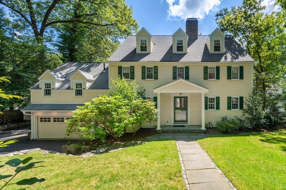
103 Loring Rd Weston, MA 02493
Estimated payment $13,274/month
Highlights
- Golf Course Community
- Medical Services
- Colonial Architecture
- Country Elementary School Rated A+
- Custom Closet System
- Landscaped Professionally
About This Home
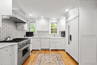
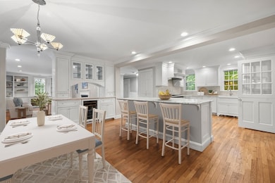
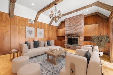
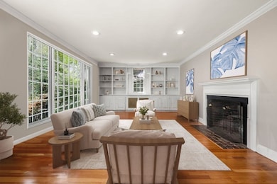
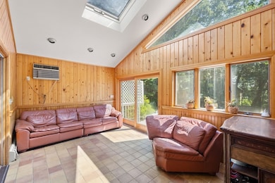
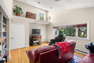
This historic Colonial in Weston’s coveted south side location combines timeless charm with thoughtful modern updates. Beautiful stone walls enhance its classic New England character. Inside, the inviting eat-in kitchen opens to a cathedral-ceiling family room with a fireplace, while a formal living room, private office, and optional first-floor bedroom provide flexibility for today’s lifestyle. The third-floor primary suite offers a serene retreat with its own sitting area, complemented by four additional bedrooms. A finished lower level is perfect for a gym, playroom, or media space. Full of character and generous space, this home is ready for your vision to make it your own. Ideally located just minutes from highways, local amenities, Weston’s premier Country Club, and top-tier schools, it offers the perfect balance of charm, potential, and convenience.
Home Details
Home Type
- Single Family
Est. Annual Taxes
- $17,255
Year Built
- Built in 1933
Lot Details
- 0.5 Acre Lot
- Stone Wall
- Landscaped Professionally
- Gentle Sloping Lot
- Sprinkler System
Parking
- 2 Car Attached Garage
- Driveway
- Open Parking
Home Design
- Colonial Architecture
- Stone Foundation
- Frame Construction
- Shingle Roof
- Concrete Perimeter Foundation
Interior Spaces
- Cathedral Ceiling
- Skylights
- Recessed Lighting
- Decorative Lighting
- Light Fixtures
- Window Screens
- Living Room with Fireplace
- 3 Fireplaces
Kitchen
- Range
- Microwave
- Freezer
- Dishwasher
- Kitchen Island
- Solid Surface Countertops
Flooring
- Wood
- Wall to Wall Carpet
- Ceramic Tile
Bedrooms and Bathrooms
- 5 Bedrooms
- Fireplace in Primary Bedroom
- Custom Closet System
Finished Basement
- Basement Fills Entire Space Under The House
- Interior Basement Entry
Outdoor Features
- Bulkhead
- Deck
- Patio
- Rain Gutters
Location
- Property is near public transit
- Property is near schools
Utilities
- Window Unit Cooling System
- Forced Air Heating and Cooling System
- 3 Cooling Zones
- 5 Heating Zones
- Heating System Uses Natural Gas
- Hot Water Heating System
- Heating System Uses Steam
- 200+ Amp Service
- Gas Water Heater
- Private Sewer
- Cable TV Available
Listing and Financial Details
- Assessor Parcel Number M:041.0 L:0004 S:000.0,868516
Community Details
Overview
- No Home Owners Association
- Near Conservation Area
Amenities
- Medical Services
- Shops
Recreation
- Golf Course Community
- Tennis Courts
- Community Pool
- Jogging Path
- Bike Trail
Map
Home Values in the Area
Average Home Value in this Area
Tax History
| Year | Tax Paid | Tax Assessment Tax Assessment Total Assessment is a certain percentage of the fair market value that is determined by local assessors to be the total taxable value of land and additions on the property. | Land | Improvement |
|---|---|---|---|---|
| 2025 | $17,255 | $1,554,500 | $629,000 | $925,500 |
| 2024 | $16,830 | $1,513,500 | $629,000 | $884,500 |
| 2023 | $16,667 | $1,407,700 | $629,000 | $778,700 |
| 2022 | $16,201 | $1,264,700 | $599,600 | $665,100 |
| 2021 | $4,395 | $1,205,900 | $571,900 | $634,000 |
| 2020 | $14,992 | $1,168,500 | $571,900 | $596,600 |
| 2019 | $14,105 | $1,120,300 | $529,500 | $590,800 |
| 2018 | $0 | $1,120,300 | $529,500 | $590,800 |
| 2017 | $13,881 | $1,119,400 | $529,500 | $589,900 |
| 2016 | $13,612 | $1,119,400 | $529,500 | $589,900 |
| 2015 | $12,570 | $1,023,600 | $450,400 | $573,200 |
Property History
| Date | Event | Price | List to Sale | Price per Sq Ft |
|---|---|---|---|---|
| 10/27/2025 10/27/25 | Price Changed | $2,250,000 | -4.3% | $606 / Sq Ft |
| 10/26/2025 10/26/25 | Pending | -- | -- | -- |
| 09/02/2025 09/02/25 | For Sale | $2,350,000 | -- | $633 / Sq Ft |
Purchase History
| Date | Type | Sale Price | Title Company |
|---|---|---|---|
| Deed | $560,000 | -- | |
| Deed | $572,900 | -- | |
| Deed | $490,000 | -- |
Mortgage History
| Date | Status | Loan Amount | Loan Type |
|---|---|---|---|
| Closed | $400,000 | No Value Available |
Source: MLS Property Information Network (MLS PIN)
MLS Number: 73424658
APN: WEST-000041-000004
Disclaimer: Certain information contained herein is derived from information provided by parties other than Homes.com. All information provided is deemed reliable, but is not guaranteed to be accurate and should be independently verified.
![]() The property listing data and information, or the Images, set forth herein were provided to MLS Property Information Network, Inc. from third party sources, including sellers, lessors and public records, and were compiled by MLS Property Information Network, Inc. The property listing data and information, and the Images, are for the personal, non-commercial use of consumers having a good faith interest in purchasing or leasing listed properties of the type displayed to them and may not be used for any purpose other than to identify prospective properties which such consumers may have a good faith interest in purchasing or leasing. MLS Property Information Network, Inc. and its subscribers disclaim any and all representations and warranties as to the accuracy of the property listing data and information, or as to the accuracy of any of the Images, set forth herein.
The property listing data and information, or the Images, set forth herein were provided to MLS Property Information Network, Inc. from third party sources, including sellers, lessors and public records, and were compiled by MLS Property Information Network, Inc. The property listing data and information, and the Images, are for the personal, non-commercial use of consumers having a good faith interest in purchasing or leasing listed properties of the type displayed to them and may not be used for any purpose other than to identify prospective properties which such consumers may have a good faith interest in purchasing or leasing. MLS Property Information Network, Inc. and its subscribers disclaim any and all representations and warranties as to the accuracy of the property listing data and information, or as to the accuracy of any of the Images, set forth herein.
- 217 Summer St
- 707 South St
- 12 Robin Rd
- 130 Summer St
- 4 Willow Rd
- 70 Possum Rd
- 60 Possum Rd
- 49 Newton St
- 2202 Commonwealth Ave Unit 2
- 2202 Commonwealth Ave Unit 1
- 217 Melrose St Unit 217
- 283 Melrose St
- 60 Rolling Ln
- 27 Oakwood Rd
- 49 Staniford St
- 41 Orchard Ave
- 154 Newton St
- 17 Lasell St
- 5 Cunningham Cir
- 209 Riverview Ave Unit 29
