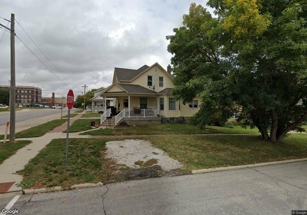
103 N Maple St Carroll, IA 51401
Estimated Value: $151,000 - $183,000
4
Beds
2
Baths
1,932
Sq Ft
$89/Sq Ft
Est. Value
About This Home
This home is located at 103 N Maple St, Carroll, IA 51401 and is currently estimated at $171,140, approximately $88 per square foot. 103 N Maple St is a home located in Carroll County with nearby schools including Fairview Elementary School, Adams Elementary School, and Carroll Middle School.
Ownership History
Date
Name
Owned For
Owner Type
Purchase Details
Closed on
Nov 14, 2021
Sold by
Acklin Properties
Bought by
Starr Dorothy K
Current Estimated Value
Purchase Details
Closed on
Nov 12, 2015
Sold by
Acklin Michele M
Bought by
Acklin Properties Llc
Purchase Details
Closed on
Nov 4, 2015
Sold by
Acklin Michele M
Bought by
Acklin Properties Llc
Home Financials for this Owner
Home Financials are based on the most recent Mortgage that was taken out on this home.
Original Mortgage
$17,246
Interest Rate
3.74%
Mortgage Type
New Conventional
Purchase Details
Closed on
Sep 10, 2015
Sold by
Us Bank Na
Bought by
Acklin Michele
Home Financials for this Owner
Home Financials are based on the most recent Mortgage that was taken out on this home.
Original Mortgage
$17,246
Interest Rate
3.74%
Mortgage Type
New Conventional
Create a Home Valuation Report for This Property
The Home Valuation Report is an in-depth analysis detailing your home's value as well as a comparison with similar homes in the area
Home Values in the Area
Average Home Value in this Area
Purchase History
| Date | Buyer | Sale Price | Title Company |
|---|---|---|---|
| Starr Dorothy K | $65,000 | Bruner Barry T | |
| Acklin Properties Llc | -- | None Available | |
| Acklin Properties Llc | -- | None Available | |
| Acklin Michele | $20,000 | None Available |
Source: Public Records
Mortgage History
| Date | Status | Borrower | Loan Amount |
|---|---|---|---|
| Previous Owner | Acklin Michele | $17,246 |
Source: Public Records
Tax History Compared to Growth
Tax History
| Year | Tax Paid | Tax Assessment Tax Assessment Total Assessment is a certain percentage of the fair market value that is determined by local assessors to be the total taxable value of land and additions on the property. | Land | Improvement |
|---|---|---|---|---|
| 2025 | $1,942 | $171,570 | $13,070 | $158,500 |
| 2024 | $1,904 | $148,130 | $13,070 | $135,060 |
| 2023 | $2,081 | $148,130 | $13,070 | $135,060 |
| 2022 | $1,972 | $136,030 | $11,880 | $124,150 |
| 2021 | $1,972 | $136,030 | $11,880 | $124,150 |
| 2020 | $2,022 | $136,030 | $11,880 | $124,150 |
| 2019 | $1,276 | $136,030 | $11,880 | $124,150 |
| 2018 | $1,202 | $136,030 | $11,880 | $124,150 |
| 2017 | $1,202 | $83,898 | $8,902 | $74,996 |
| 2016 | $998 | $78,410 | $0 | $0 |
| 2015 | $998 | $74,360 | $0 | $0 |
| 2014 | $928 | $74,360 | $0 | $0 |
Source: Public Records
Map
Nearby Homes
- 519 E 1st St
- 120 E 1st St Unit 2
- 409 E Valley Dr
- 121 S West St
- 804 N Clark St
- 308 Prairie View Dr
- 807 N Court St
- 19383 U S 30
- 332 N Crawford St
- Deer Creek Ln Lot 36
- 727 N Adams St
- 926 N Court St
- 619 W 2nd St
- 407 Westridge Dr
- 1026 N Clark St
- 0 Deer Creek Ln Unit 6302348
- 629 Meadow Ln
- 1015 N Adams St
- 1102 N Main St
- 1108 N Main St