Estimated Value: $54,690 - $91,000
Studio
--
Bath
2,056
Sq Ft
$36/Sq Ft
Est. Value
About This Home
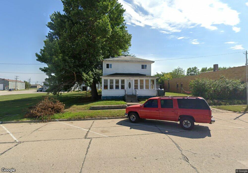
This home is located at 103 Walnut St, Burt, IA 50522 and is currently estimated at $74,423, approximately $36 per square foot. 103 Walnut St is a home with nearby schools including Bertha Godfrey Elementary School, Bryant Elementary School, and Lucia Wallace Elementary School.
Ownership History
Date
Name
Owned For
Owner Type
Purchase Details
Closed on
Dec 20, 2024
Sold by
Iat 81 Llc
Bought by
Hall Timothy James
Current Estimated Value
Purchase Details
Closed on
Nov 21, 2022
Sold by
Swegan Amanda
Bought by
Iat 81 Llc
Purchase Details
Closed on
Mar 18, 2014
Sold by
Scott Leff Roth 401 K Trust
Bought by
Dean James B and Dean Nicole
Purchase Details
Closed on
Mar 14, 2014
Sold by
Tf 18 Ccsb Llc
Bought by
Scott Leff Roth 401K Trust
Purchase Details
Closed on
Feb 10, 2010
Sold by
Riles Shirley Diane
Bought by
Riles Jeffery J
Create a Home Valuation Report for This Property
The Home Valuation Report is an in-depth analysis detailing your home's value as well as a comparison with similar homes in the area
Purchase History
| Date | Buyer | Sale Price | Title Company |
|---|---|---|---|
| Hall Timothy James | $7,500 | None Listed On Document | |
| Iat 81 Llc | -- | -- | |
| Dean James B | $4,000 | None Available | |
| Scott Leff Roth 401K Trust | -- | None Available | |
| Riles Jeffery J | -- | None Available |
Source: Public Records
Tax History
| Year | Tax Paid | Tax Assessment Tax Assessment Total Assessment is a certain percentage of the fair market value that is determined by local assessors to be the total taxable value of land and additions on the property. | Land | Improvement |
|---|---|---|---|---|
| 2025 | $516 | $30,139 | $4,125 | $26,014 |
| 2024 | $516 | $30,803 | $4,125 | $26,678 |
| 2023 | $534 | $30,803 | $4,125 | $26,678 |
| 2022 | $402 | $30,511 | $4,125 | $26,386 |
| 2021 | $526 | $23,480 | $4,125 | $19,355 |
| 2020 | $518 | $29,655 | $3,750 | $25,905 |
| 2019 | $546 | $30,327 | $0 | $0 |
| 2018 | $528 | $30,327 | $0 | $0 |
| 2017 | $116 | $15,123 | $0 | $0 |
| 2016 | $108 | $15,123 | $0 | $0 |
| 2015 | $244 | $14,328 | $0 | $0 |
| 2014 | -- | $14,328 | $0 | $0 |
Source: Public Records
Map
Nearby Homes
- 406 5th St
- 606 Walnut St
- 1409 330th St
- 203 Oregon St
- 208 W Public St
- 108 E Center St
- 702 260th St
- 308 E Ramsey St
- 317 U S 18
- 1303 N Country Club Rd
- 1809 E Locust St
- 1213 N Country Club Rd
- 2109 E Spruce St
- 2317 E Spruce St
- 908 N Wooster St
- 905 N Wooster St
- 730 N Durant St
- 702 Diagonal St
- 931 E Oak St
- 720 N Thorington St
Your Personal Tour Guide
Ask me questions while you tour the home.