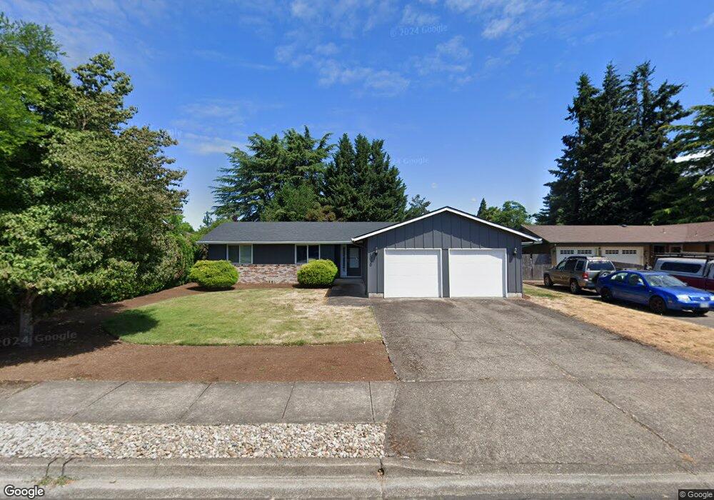
1030 Island St Springfield, OR 97477
West Springfield NeighborhoodEstimated Value: $392,000 - $431,000
3
Beds
2
Baths
1,140
Sq Ft
$362/Sq Ft
Est. Value
About This Home
This home is located at 1030 Island St, Springfield, OR 97477 and is currently estimated at $412,676, approximately $361 per square foot. 1030 Island St is a home located in Lane County with nearby schools including Centennial Elementary School, Hamlin Middle School, and Springfield High School.
Ownership History
Date
Name
Owned For
Owner Type
Purchase Details
Closed on
May 11, 2004
Sold by
Bink Debra Kay
Bought by
Clayton Pamela S
Current Estimated Value
Home Financials for this Owner
Home Financials are based on the most recent Mortgage that was taken out on this home.
Original Mortgage
$146,921
Outstanding Balance
$67,846
Interest Rate
5.5%
Mortgage Type
FHA
Estimated Equity
$344,830
Purchase Details
Closed on
Jun 22, 2000
Sold by
Campos Roy D
Bought by
Campos Debra K
Purchase Details
Closed on
Dec 4, 1997
Sold by
Dorothy Anderson and Dorothy Lowell M
Bought by
Campos Roy D and Campos Debra K
Home Financials for this Owner
Home Financials are based on the most recent Mortgage that was taken out on this home.
Original Mortgage
$114,162
Interest Rate
7.23%
Mortgage Type
FHA
Create a Home Valuation Report for This Property
The Home Valuation Report is an in-depth analysis detailing your home's value as well as a comparison with similar homes in the area
Home Values in the Area
Average Home Value in this Area
Purchase History
| Date | Buyer | Sale Price | Title Company |
|---|---|---|---|
| Clayton Pamela S | $149,000 | Fidelity Natl Title Co Of Or | |
| Campos Debra K | -- | Evergreen Land Title Co | |
| Campos Roy D | $114,900 | American Title Group Inc |
Source: Public Records
Mortgage History
| Date | Status | Borrower | Loan Amount |
|---|---|---|---|
| Open | Clayton Pamela S | $146,921 | |
| Previous Owner | Campos Roy D | $114,162 |
Source: Public Records
Tax History
| Year | Tax Paid | Tax Assessment Tax Assessment Total Assessment is a certain percentage of the fair market value that is determined by local assessors to be the total taxable value of land and additions on the property. | Land | Improvement |
|---|---|---|---|---|
| 2025 | $4,189 | $228,432 | -- | -- |
| 2024 | $4,121 | $221,779 | -- | -- |
| 2023 | $4,121 | $215,320 | $0 | $0 |
| 2022 | $3,817 | $209,049 | $0 | $0 |
| 2021 | $3,748 | $202,961 | $0 | $0 |
| 2020 | $3,639 | $197,050 | $0 | $0 |
| 2019 | $3,529 | $191,311 | $0 | $0 |
| 2018 | $3,327 | $180,329 | $0 | $0 |
| 2017 | $3,199 | $180,329 | $0 | $0 |
| 2016 | $3,132 | $175,077 | $0 | $0 |
| 2015 | $3,024 | $169,978 | $0 | $0 |
| 2014 | $2,979 | $165,027 | $0 | $0 |
Source: Public Records
Map
Nearby Homes
- 1074 Hamilton St
- 930 Prescott Ln
- 1505 Canal St
- 952 Summit Blvd
- 835 Anderson Ln
- 804 W N St
- 552 W D St
- 428 W Centennial Blvd
- 1130 Anderson Ln
- 535 Pacific Ave
- 207 W D St
- 485 Scotts Glen Dr
- 898 Lochaven Ave
- 3955 E 17th Ave
- 239 D St
- 364 Scotts Glen Dr
- 451 Lochaven Ave
- 1109 4th St
- 3360 Chevy Chase St
- 1006 5th St
Your Personal Tour Guide
Ask me questions while you tour the home.