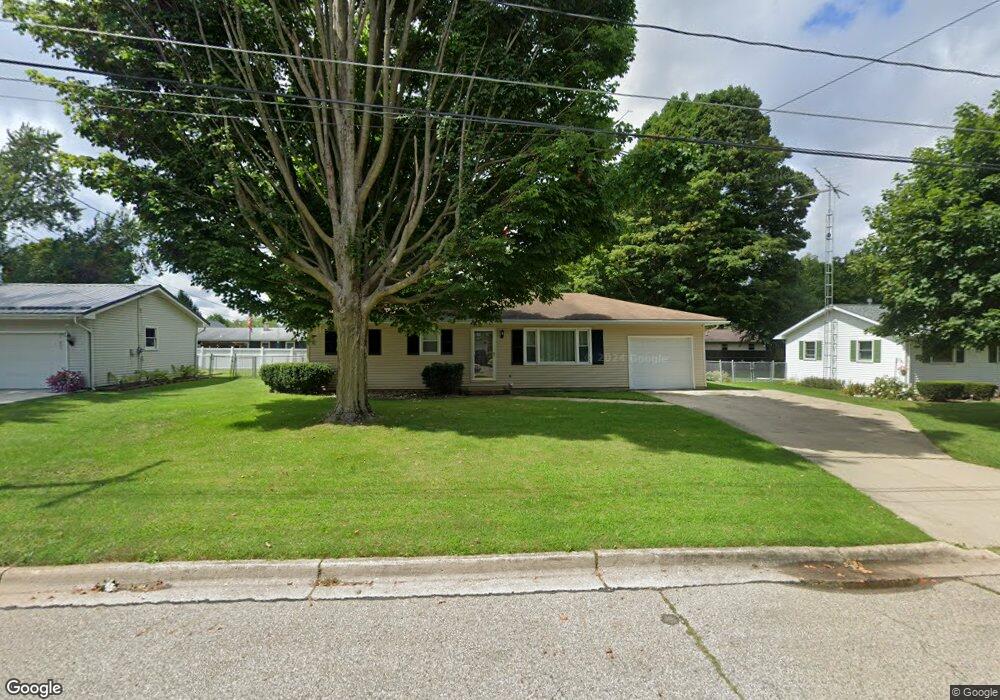
1030 Lowe Dr Marshall, MI 49068
Estimated Value: $206,754 - $222,000
3
Beds
1
Bath
1,040
Sq Ft
$208/Sq Ft
Est. Value
About This Home
This home is located at 1030 Lowe Dr, Marshall, MI 49068 and is currently estimated at $215,939, approximately $207 per square foot. 1030 Lowe Dr is a home located in Calhoun County with nearby schools including Harrington Elementary School, Marshall High School, and Marshall Academy.
Ownership History
Date
Name
Owned For
Owner Type
Purchase Details
Closed on
Oct 3, 2023
Sold by
Brisson Sean and Brisson Dawn D
Bought by
Brisson Sean
Current Estimated Value
Purchase Details
Closed on
Sep 15, 2010
Sold by
Brisson Sean and Brisson Sean P
Bought by
Brisson Sean and Boblet Dawn D
Purchase Details
Closed on
Jan 6, 2006
Sold by
Brisson Marie Ann
Bought by
Brisson Sean Parnell
Purchase Details
Closed on
Apr 25, 2003
Sold by
Huestis Ellwood J and Huestis Priscilla
Bought by
Brisson Sean
Purchase Details
Closed on
Jun 30, 1999
Sold by
Anderson Gregory J and Anderson Linda C
Bought by
Huestis Ellwood J and Huestis Priscilla
Purchase Details
Closed on
Oct 28, 1998
Sold by
Lohrke Linda C
Bought by
Anderson Gregory J and Anderson Linda C
Purchase Details
Closed on
Aug 18, 1995
Sold by
Lohrke Lee Roy and Lohrke Linda
Bought by
Lohrke Linda C
Purchase Details
Closed on
Mar 1, 1988
Create a Home Valuation Report for This Property
The Home Valuation Report is an in-depth analysis detailing your home's value as well as a comparison with similar homes in the area
Home Values in the Area
Average Home Value in this Area
Purchase History
| Date | Buyer | Sale Price | Title Company |
|---|---|---|---|
| Brisson Sean | -- | None Listed On Document | |
| Brisson Sean | -- | None Available | |
| Brisson Sean Parnell | -- | None Available | |
| Brisson Sean | $123,500 | -- | |
| Huestis Ellwood J | $103,900 | -- | |
| Anderson Gregory J | -- | -- | |
| Lohrke Linda C | $100 | -- | |
| -- | $45,000 | -- |
Source: Public Records
Tax History
| Year | Tax Paid | Tax Assessment Tax Assessment Total Assessment is a certain percentage of the fair market value that is determined by local assessors to be the total taxable value of land and additions on the property. | Land | Improvement |
|---|---|---|---|---|
| 2025 | $2,961 | $93,600 | $0 | $0 |
| 2024 | $582 | $85,800 | $0 | $0 |
| 2023 | $2,657 | $82,900 | $0 | $0 |
| 2022 | $2,125 | $70,900 | $0 | $0 |
| 2021 | $2,576 | $70,300 | $0 | $0 |
| 2020 | $2,436 | $62,200 | $0 | $0 |
| 2019 | $0 | $57,500 | $0 | $0 |
| 2018 | $0 | $57,300 | $10,400 | $46,900 |
| 2017 | $0 | $54,800 | $0 | $0 |
| 2016 | $0 | $55,900 | $0 | $0 |
| 2015 | -- | $42,700 | $0 | $0 |
| 2014 | -- | $42,500 | $0 | $0 |
Source: Public Records
Map
Nearby Homes
- 1043 Rose St
- 1027 Rebecca St Unit 14
- 1050 Rebecca St Unit 18
- 133 W Hughes St
- 1060 S Kalamazoo Ave
- 1048 S Kalamazoo Ave
- 901 S Kalamazoo Ave
- 816 S Kalamazoo Ave
- 1025 Rebecca St Unit 15
- 1029 Rebecca St Unit 13
- 1048 Rebecca St Unit 19
- 1049 Rebecca St Unit 3
- 103 Hart St
- 107 Hart St
- 126 W Hanover St
- 217 S Marshall Ave
- 215 S Liberty St
- 741 Montgomery St
- 106 S Marshall Ave
- 620 E Green St
Your Personal Tour Guide
Ask me questions while you tour the home.