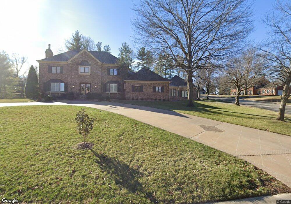
1030 W Laurel Rd Joplin, MO 64801
Roanoke NeighborhoodEstimated Value: $507,000 - $764,000
5
Beds
4
Baths
5,700
Sq Ft
$110/Sq Ft
Est. Value
About This Home
This home is located at 1030 W Laurel Rd, Joplin, MO 64801 and is currently estimated at $624,319, approximately $109 per square foot. 1030 W Laurel Rd is a home located in Jasper County with nearby schools including North Middle School and Joplin High School.
Ownership History
Date
Name
Owned For
Owner Type
Purchase Details
Closed on
Jul 22, 2016
Sold by
Peterson William and Peterson Lauren
Bought by
Robertson Mathew and Robertson Lauren
Current Estimated Value
Home Financials for this Owner
Home Financials are based on the most recent Mortgage that was taken out on this home.
Original Mortgage
$148,800
Outstanding Balance
$118,544
Interest Rate
3.6%
Mortgage Type
New Conventional
Estimated Equity
$505,775
Purchase Details
Closed on
Jan 25, 2010
Sold by
Fuller Stephen W and Fuller Margaret C
Bought by
Hurn Jhan and Hurn Laura
Create a Home Valuation Report for This Property
The Home Valuation Report is an in-depth analysis detailing your home's value as well as a comparison with similar homes in the area
Home Values in the Area
Average Home Value in this Area
Purchase History
| Date | Buyer | Sale Price | Title Company |
|---|---|---|---|
| Robertson Mathew | -- | -- | |
| Robertson Mathew | -- | -- | |
| Hurn Jhan | -- | Jct |
Source: Public Records
Mortgage History
| Date | Status | Borrower | Loan Amount |
|---|---|---|---|
| Open | Robertson Mathew | $148,800 | |
| Closed | Robertson Mathew | $27,900 | |
| Closed | Robertson Mathew | $148,800 |
Source: Public Records
Tax History
| Year | Tax Paid | Tax Assessment Tax Assessment Total Assessment is a certain percentage of the fair market value that is determined by local assessors to be the total taxable value of land and additions on the property. | Land | Improvement |
|---|---|---|---|---|
| 2025 | $3,747 | $90,410 | $9,540 | $80,870 |
| 2024 | $3,745 | $81,150 | $9,540 | $71,610 |
| 2023 | $3,745 | $81,150 | $9,540 | $71,610 |
| 2022 | $3,785 | $82,290 | $9,540 | $72,750 |
| 2021 | $3,760 | $82,290 | $9,540 | $72,750 |
| 2020 | $3,542 | $75,850 | $9,540 | $66,310 |
| 2019 | $3,550 | $75,850 | $9,540 | $66,310 |
| 2018 | $3,223 | $69,130 | $0 | $0 |
| 2017 | $3,235 | $69,130 | $0 | $0 |
| 2016 | $3,302 | $71,500 | $0 | $0 |
Source: Public Records
Map
Nearby Homes
- 1324 Fairmont Dr
- 1025 Northridge Rd
- 1302 Cambridge St
- 1232 Bramar Dr
- 639 W Jaccard Place
- 802 Hampton Place
- 1005 N Moffet Ave
- 624 N Sergeant Ave
- 705 N Moffet Ave
- 634 N Byers Ave
- 528 N Sergeant Ave
- 728 N Pearl Ave
- 602 N Byers Ave
- 530 N Pearl Ave
- TBD Perkins St
- 531 N Wall Ave
- 301 N Connor Ave Unit 305
- 319 N Moffet Ave
- 225 N Jackson Ave
- 921 W A St
- 1015 W Kensington Rd
- 1021 W Kensington Rd
- 1307 Sheridan Dr
- 1222 Sheridan Dr
- 1212 Sheridan Dr
- 1304 Fairmont Dr
- 1306 Sheridan Dr
- 1010 W Laurel Rd
- 1317 Sheridan Dr
- 1317 Sheridan Dr Unit 1
- 1016 W Kensington Rd
- 1202 Sheridan Dr
- 1314 Fairmont Dr
- 1020 W Kensington Rd
- 1012 W Kensington Rd
- 1314 Sheridan Dr
- 1311 Fairmont Dr
- 1008 W Kensington Rd
- 1122 Sheridan Dr
- 1321 Sheridan Dr
Your Personal Tour Guide
Ask me questions while you tour the home.