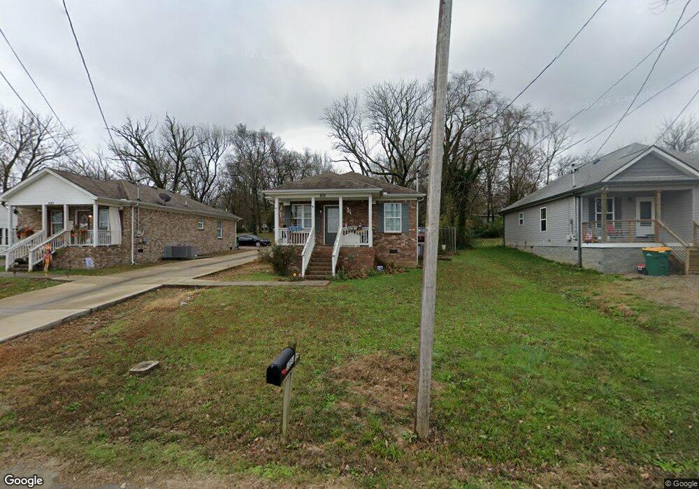
1031 Silver Creek Rd Lewisburg, TN 37091
Estimated Value: $189,000 - $224,000
--
Bed
1
Bath
1,008
Sq Ft
$206/Sq Ft
Est. Value
About This Home
This home is located at 1031 Silver Creek Rd, Lewisburg, TN 37091 and is currently estimated at $207,606, approximately $205 per square foot. 1031 Silver Creek Rd is a home located in Marshall County with nearby schools including Marshall Elementary School, Oak Grove Elementary School, and Westhills Elementary School.
Ownership History
Date
Name
Owned For
Owner Type
Purchase Details
Closed on
Oct 16, 2013
Sold by
Bank Of Frankewing
Bought by
Tankersley Edward B and Tankersley Lynn W
Current Estimated Value
Purchase Details
Closed on
Mar 19, 2012
Sold by
Love Gary Wayne
Bought by
Bank Of Frankewing
Purchase Details
Closed on
Jun 11, 2008
Bought by
Love Gary Wayne and Love Elizabeth Clair
Purchase Details
Closed on
Jan 11, 2008
Bought by
Bank Of Frankewing
Purchase Details
Closed on
Aug 17, 1999
Sold by
Charles Allen
Bought by
Patrick Smith
Purchase Details
Closed on
Jun 29, 1987
Bought by
Allen Charles
Create a Home Valuation Report for This Property
The Home Valuation Report is an in-depth analysis detailing your home's value as well as a comparison with similar homes in the area
Home Values in the Area
Average Home Value in this Area
Purchase History
| Date | Buyer | Sale Price | Title Company |
|---|---|---|---|
| Tankersley Edward B | $2,000 | -- | |
| Bank Of Frankewing | $675,000 | -- | |
| Love Gary Wayne | $1,100,000 | -- | |
| Bank Of Frankewing | $400,000 | -- | |
| Patrick Smith | $2,400 | -- | |
| Allen Charles | $22,000 | -- |
Source: Public Records
Tax History Compared to Growth
Tax History
| Year | Tax Paid | Tax Assessment Tax Assessment Total Assessment is a certain percentage of the fair market value that is determined by local assessors to be the total taxable value of land and additions on the property. | Land | Improvement |
|---|---|---|---|---|
| 2024 | -- | $40,625 | $6,250 | $34,375 |
| 2023 | $1,261 | $40,625 | $6,250 | $34,375 |
| 2022 | $1,261 | $40,625 | $6,250 | $34,375 |
| 2021 | $915 | $19,650 | $2,000 | $17,650 |
| 2020 | $915 | $19,650 | $2,000 | $17,650 |
| 2019 | $885 | $19,650 | $2,000 | $17,650 |
| 2018 | $875 | $19,650 | $2,000 | $17,650 |
| 2017 | $875 | $19,650 | $2,000 | $17,650 |
| 2016 | $358 | $6,975 | $1,875 | $5,100 |
| 2015 | $88 | $1,875 | $1,875 | $0 |
| 2014 | $88 | $1,875 | $1,875 | $0 |
Source: Public Records
Map
Nearby Homes
- 1111 W End Ave N
- 108 W End Ave N
- 1144 Apple St
- 1221 W Commerce St
- 251 Joyce Ave
- 240 Joyce Ave
- 1371 W Commerce St
- 238 Hopkins Ave
- 0 New Lake Rd Unit RTC3030964
- 726 Thomas Ave
- 610 Forrest St
- 630 6th Ave N
- 518 Maple St
- 525 Maple St
- 215 5th Ave N
- 627 6th Ave N
- 594 5th Ave N
- 655 Glenn Ave
- 0 Joyce Ave
- 316 Haynes St
- 1023 Silver Creek Rd
- 1041 Silver Creek Rd
- 1043 Silver Creek Rd
- 1019 Silver Creek Rd
- 1047 Silver Creek Rd
- 1003 Silver Creek Rd
- 1030 Silver Creek Rd
- 1044 Bryant St
- 1036 Silver Creek Rd
- 1050 Silver Creek Rd
- 1049 Silver Creek Rd
- 411 Kings Ln
- 1054 Bryant St
- 1030 Bryant St
- 1058 Bryant St
- 1062 Silver Creek Rd
- 412 Heil Quaker Ave
- 1039 Bryant St
- 1023 Bryant St
- 1043 Bryant St