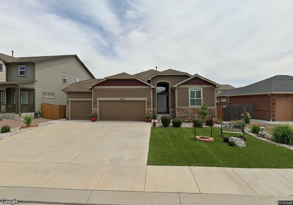
10317 Declaration Dr Colorado Springs, CO 80925
Widefield NeighborhoodEstimated Value: $510,000 - $548,000
5
Beds
4
Baths
3,424
Sq Ft
$153/Sq Ft
Est. Value
About This Home
This home is located at 10317 Declaration Dr, Colorado Springs, CO 80925 and is currently estimated at $524,587, approximately $153 per square foot. 10317 Declaration Dr is a home located in El Paso County with nearby schools including Grand Mountain School, Mesa Ridge High School, and Valley Christian Academy.
Ownership History
Date
Name
Owned For
Owner Type
Purchase Details
Closed on
Jun 6, 2025
Sold by
Craig Larry
Bought by
Craig Valerie
Current Estimated Value
Purchase Details
Closed on
Sep 18, 2017
Sold by
Halvis Stephen and Halvis Lucita
Bought by
Craig Larry and Craig Valerie
Home Financials for this Owner
Home Financials are based on the most recent Mortgage that was taken out on this home.
Original Mortgage
$200,000
Interest Rate
3.93%
Mortgage Type
Commercial
Purchase Details
Closed on
Feb 28, 2014
Sold by
Saint Aubyn Homes Llc
Bought by
Halvis Stephen and Halvis Lucita
Home Financials for this Owner
Home Financials are based on the most recent Mortgage that was taken out on this home.
Original Mortgage
$290,000
Interest Rate
4.44%
Mortgage Type
VA
Create a Home Valuation Report for This Property
The Home Valuation Report is an in-depth analysis detailing your home's value as well as a comparison with similar homes in the area
Home Values in the Area
Average Home Value in this Area
Purchase History
| Date | Buyer | Sale Price | Title Company |
|---|---|---|---|
| Craig Valerie | -- | None Listed On Document | |
| Craig Larry | $333,000 | Unified Title Co | |
| Halvis Stephen | $300,200 | Heritage Title |
Source: Public Records
Mortgage History
| Date | Status | Borrower | Loan Amount |
|---|---|---|---|
| Previous Owner | Craig Larry | $200,000 | |
| Previous Owner | Halvis Stephen | $290,000 |
Source: Public Records
Tax History Compared to Growth
Tax History
| Year | Tax Paid | Tax Assessment Tax Assessment Total Assessment is a certain percentage of the fair market value that is determined by local assessors to be the total taxable value of land and additions on the property. | Land | Improvement |
|---|---|---|---|---|
| 2025 | $4,879 | $34,890 | -- | -- |
| 2024 | $4,841 | $36,110 | $6,040 | $30,070 |
| 2022 | $3,574 | $25,820 | $4,810 | $21,010 |
| 2021 | $3,721 | $26,560 | $4,950 | $21,610 |
| 2020 | $3,630 | $25,640 | $4,330 | $21,310 |
| 2019 | $3,619 | $25,640 | $4,330 | $21,310 |
| 2018 | $3,072 | $21,430 | $4,360 | $17,070 |
| 2017 | $3,136 | $21,430 | $4,360 | $17,070 |
| 2016 | $3,080 | $23,800 | $4,380 | $19,420 |
| 2015 | $3,245 | $23,800 | $4,380 | $19,420 |
| 2014 | $3,231 | $23,800 | $4,290 | $19,510 |
Source: Public Records
Map
Nearby Homes
- 10202 Abrams Dr
- 10208 Abrams Dr
- 10179 Seawolf Dr
- 6572 Justice Way
- 10868 Deer Meadow Cir
- 10250 Intrepid Way
- 10732 Deer Meadow Cir
- 10405 Abrams Dr
- 10394 Abrams Dr
- 6868 Alsea Dr
- 10670 Abrams Dr
- 10604 Deer Meadow Cir
- 6562 Phantom Way
- 10442 Abrams Dr
- 6225 Laurel Grass Range Trail
- 10634 Abrams Dr
- 6672 Kearsarge Dr
- 10568 Kalama Dr
- 6441 Old Glory Dr
- 6431 Old Glory Dr
- 10323 Declaration Dr
- 6902 Alliance Loop
- 6910 Alliance Loop
- 10329 Declaration Dr
- 6918 Alliance Loop
- 10315 Declaration Dr
- 6894 Alliance Loop
- 10318 Declaration Dr
- 6926 Alliance Loop
- 10312 Declaration Dr
- 10324 Declaration Dr
- 10335 Declaration Dr
- 10201 Abrams Dr
- 6886 Alliance Loop
- 10330 Declaration Dr
- 6440 Nassau Trail
- 10207 Abrams Dr
- 6909 Alliance Loop
- 6917 Alliance Loop
- 6510 Alliance Loop