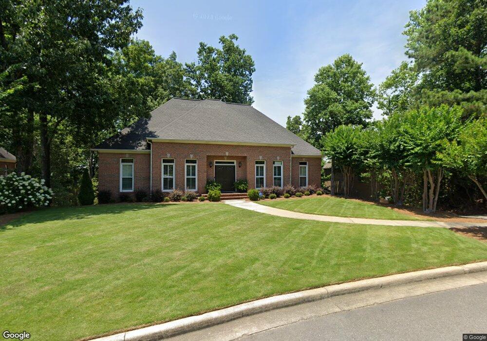
1033 Cole Cir Birmingham, AL 35242
Estimated Value: $572,899 - $608,000
5
Beds
4
Baths
3,292
Sq Ft
$180/Sq Ft
Est. Value
About This Home
This home is located at 1033 Cole Cir, Birmingham, AL 35242 and is currently estimated at $592,975, approximately $180 per square foot. 1033 Cole Cir is a home located in Shelby County with nearby schools including Oak Mountain Elementary School, Oak Mountain Intermediate School, and Oak Mt. Middle School.
Ownership History
Date
Name
Owned For
Owner Type
Purchase Details
Closed on
Jul 19, 2002
Sold by
Cendant Mobility Financial Corp
Bought by
Ammon Jeffrey S and Ammon Melissa A
Current Estimated Value
Home Financials for this Owner
Home Financials are based on the most recent Mortgage that was taken out on this home.
Original Mortgage
$220,800
Outstanding Balance
$93,004
Interest Rate
6.62%
Estimated Equity
$499,971
Purchase Details
Closed on
Jul 11, 2002
Sold by
Soltys Edward W and Soltys Heidi S
Bought by
Cendant Mobility Financial Corp
Home Financials for this Owner
Home Financials are based on the most recent Mortgage that was taken out on this home.
Original Mortgage
$220,800
Outstanding Balance
$93,004
Interest Rate
6.62%
Estimated Equity
$499,971
Purchase Details
Closed on
May 18, 1998
Sold by
Soltys Edward W
Bought by
Soltys Edward W and Soltys Heidi S
Home Financials for this Owner
Home Financials are based on the most recent Mortgage that was taken out on this home.
Original Mortgage
$185,000
Interest Rate
7.25%
Create a Home Valuation Report for This Property
The Home Valuation Report is an in-depth analysis detailing your home's value as well as a comparison with similar homes in the area
Home Values in the Area
Average Home Value in this Area
Purchase History
| Date | Buyer | Sale Price | Title Company |
|---|---|---|---|
| Ammon Jeffrey S | $276,000 | -- | |
| Cendant Mobility Financial Corp | $276,000 | -- | |
| Soltys Edward W | $30,000 | Cahaba Title Inc |
Source: Public Records
Mortgage History
| Date | Status | Borrower | Loan Amount |
|---|---|---|---|
| Open | Ammon Jeffrey S | $220,800 | |
| Previous Owner | Soltys Edward W | $185,000 |
Source: Public Records
Tax History Compared to Growth
Tax History
| Year | Tax Paid | Tax Assessment Tax Assessment Total Assessment is a certain percentage of the fair market value that is determined by local assessors to be the total taxable value of land and additions on the property. | Land | Improvement |
|---|---|---|---|---|
| 2024 | $2,130 | $48,400 | $0 | $0 |
| 2023 | $2,031 | $47,080 | $0 | $0 |
| 2022 | $1,698 | $39,520 | $0 | $0 |
| 2021 | $1,584 | $36,940 | $0 | $0 |
| 2020 | $1,559 | $36,360 | $0 | $0 |
| 2019 | $1,552 | $36,200 | $0 | $0 |
| 2017 | $1,541 | $35,960 | $0 | $0 |
| 2015 | $1,469 | $34,320 | $0 | $0 |
| 2014 | $1,433 | $33,500 | $0 | $0 |
Source: Public Records
Map
Nearby Homes
- 8028 Eagle Crest Ln Unit 7
- 8024 Eagle Crest Ln
- 100 Emily Cir
- 2049 Eagle Point Ct
- 826 Griffin Park Cir
- 6225 Eagle Point Cir
- 2336 Woodland Cir
- 415 Griffin Park Ln
- 765 Griffin Park Cir
- 1017 Eagle Valley Dr
- 5032 Stone Bridge Ln
- 164 Bridge Dr
- 5391 Harvest Ridge Ln
- 4713 Eagle Wood Ct
- 701 Talon Cove
- 5010 Mark Trail
- 4700 Eagle Wood Ct
- 6130 Eagle Point Cir
- 4449 Eagle Point Dr
- 415 Talon Cir
- 1029 Cole Cir
- 1048 Cole Cir
- 1025 Cole Cir
- 1044 Cole Cir
- 1032 Cole Cir
- 8020 Eagle Crest Ln
- 5568 Triple Ln W Unit 7
- 5568 Triple Ln W Unit 8
- 1036 Cole Cir
- 1028 Cole Cir
- 1040 Cole Cir
- 1021 Cole Cir
- 1020 Cole Cir
- 8012 Eagle Crest Ln
- 8016 Eagle Crest Ln
- 1013 Cole Cir
- 1016 Cole Cir
- 8024 Eagle Crest Ln Unit 15
- 5029 Eagle Crest Rd
- 1012 Cole Cir