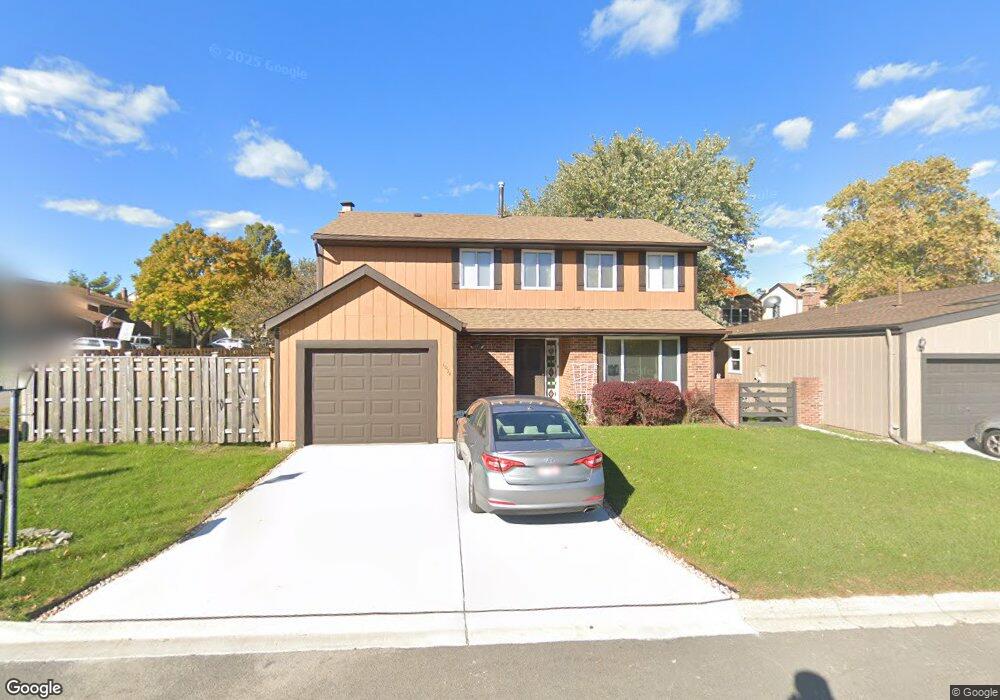
1034 Bob o Link Dr Darien, IL 60561
Estimated Value: $402,000 - $420,000
4
Beds
3
Baths
1,800
Sq Ft
$228/Sq Ft
Est. Value
About This Home
This home is located at 1034 Bob o Link Dr, Darien, IL 60561 and is currently estimated at $410,004, approximately $227 per square foot. 1034 Bob o Link Dr is a home located in DuPage County with nearby schools including Concord Elementary School, Cass Jr High School, and Hinsdale South High School.
Ownership History
Date
Name
Owned For
Owner Type
Purchase Details
Closed on
Nov 4, 2023
Sold by
Thomas Cherian and Thomas Rosamma
Bought by
Cherian Thomas And Rosamma Thomas Trust and Thomas
Current Estimated Value
Purchase Details
Closed on
Jul 18, 1996
Sold by
Krohse James A and Foster Krohse Maricia A
Bought by
Thomas Cherian and Thomas Rosamma
Home Financials for this Owner
Home Financials are based on the most recent Mortgage that was taken out on this home.
Original Mortgage
$137,750
Interest Rate
8.33%
Mortgage Type
Purchase Money Mortgage
Create a Home Valuation Report for This Property
The Home Valuation Report is an in-depth analysis detailing your home's value as well as a comparison with similar homes in the area
Home Values in the Area
Average Home Value in this Area
Purchase History
| Date | Buyer | Sale Price | Title Company |
|---|---|---|---|
| Cherian Thomas And Rosamma Thomas Trust | -- | None Listed On Document | |
| Thomas Cherian | $145,000 | Attorneys Title Guaranty Fun |
Source: Public Records
Mortgage History
| Date | Status | Borrower | Loan Amount |
|---|---|---|---|
| Previous Owner | Thomas Cherian | $137,750 |
Source: Public Records
Tax History Compared to Growth
Tax History
| Year | Tax Paid | Tax Assessment Tax Assessment Total Assessment is a certain percentage of the fair market value that is determined by local assessors to be the total taxable value of land and additions on the property. | Land | Improvement |
|---|---|---|---|---|
| 2024 | $6,162 | $111,391 | $27,478 | $83,913 |
| 2023 | $5,876 | $102,400 | $25,260 | $77,140 |
| 2022 | $5,238 | $88,950 | $21,940 | $67,010 |
| 2021 | $5,238 | $87,940 | $21,690 | $66,250 |
| 2020 | $4,762 | $86,200 | $21,260 | $64,940 |
| 2019 | $4,901 | $82,710 | $20,400 | $62,310 |
| 2018 | $4,290 | $74,850 | $18,460 | $56,390 |
| 2017 | $4,237 | $72,020 | $17,760 | $54,260 |
| 2016 | $4,110 | $68,730 | $16,950 | $51,780 |
| 2015 | $4,020 | $64,670 | $15,950 | $48,720 |
| 2014 | $4,171 | $66,190 | $16,330 | $49,860 |
| 2013 | $4,010 | $65,880 | $16,250 | $49,630 |
Source: Public Records
Map
Nearby Homes
- 1018 Bob-O-link Ln
- 8408 Dawn Ln
- 8122 Ripple Ridge
- 9S080 Stratford Place
- 17W455 Concord Place
- Lot 1, 2, 3, 4 & 5 Nantucket Dr
- 1310 Iroquois Ln
- 1390 Marco Ct
- 1370 Marco Ct
- 7930 Grant St
- 801 79th St Unit 105
- 709 79th St Unit 103
- 709 79th St Unit 307
- 709 79th St Unit 403
- 8301 Highpoint Cir Unit C
- 8320 Highpoint Cir Unit 8230-F
- 7817 Mayfair Ln
- 7713 Brookhaven Ave
- 8081 Tennessee Ave
- 716 Somerset Ln
- 1030 Bob o Link Dr Unit 3
- 1033 Meadowlark Ln
- 1029 Meadowlark Ln
- 1026 Bob o Link Dr
- 1033 Bob o Link Dr
- 1029 Bob o Link Dr
- 8210 Hinswood Dr
- 8206 Hinswood Dr
- 1025 Meadowlark Ln
- 1025 Bob o Link Dr
- 8142 Hinswood Dr
- 1022 Bob o Link Dr
- 1021 Meadowlark Ln
- 1021 Bob o Link Dr
- 8136 Hinswood Dr
- 8209 Park Crest Dr
- 8205 Park Crest Dr
- 1026 Meadowlark Ln
- 1041 Bob o Link Dr
- 8201 Park Crest Dr Unit 3