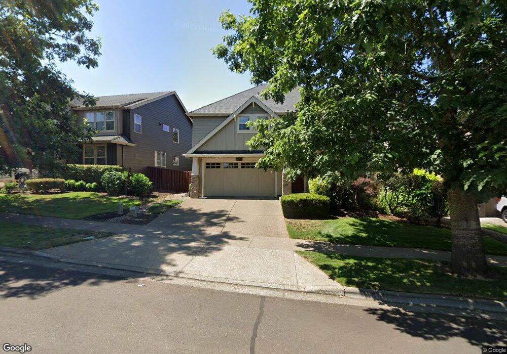
1034 Stonewall Ave Forest Grove, OR 97116
Estimated Value: $641,000 - $704,000
3
Beds
3
Baths
2,834
Sq Ft
$234/Sq Ft
Est. Value
About This Home
This home is located at 1034 Stonewall Ave, Forest Grove, OR 97116 and is currently estimated at $661,893, approximately $233 per square foot. 1034 Stonewall Ave is a home located in Washington County with nearby schools including Dilley Elementary School, Tom McCall Upper Elementary School, and Neil Armstrong Middle School.
Ownership History
Date
Name
Owned For
Owner Type
Purchase Details
Closed on
Feb 25, 2008
Sold by
Renaissance Custom Homes Llc
Bought by
Mannen Michael O and Mannen Shannon L
Current Estimated Value
Home Financials for this Owner
Home Financials are based on the most recent Mortgage that was taken out on this home.
Original Mortgage
$352,536
Outstanding Balance
$217,374
Interest Rate
5.72%
Mortgage Type
Unknown
Estimated Equity
$444,519
Create a Home Valuation Report for This Property
The Home Valuation Report is an in-depth analysis detailing your home's value as well as a comparison with similar homes in the area
Home Values in the Area
Average Home Value in this Area
Purchase History
| Date | Buyer | Sale Price | Title Company |
|---|---|---|---|
| Mannen Michael O | $444,000 | Lawyers Title Ins |
Source: Public Records
Mortgage History
| Date | Status | Borrower | Loan Amount |
|---|---|---|---|
| Open | Mannen Michael O | $352,536 |
Source: Public Records
Tax History Compared to Growth
Tax History
| Year | Tax Paid | Tax Assessment Tax Assessment Total Assessment is a certain percentage of the fair market value that is determined by local assessors to be the total taxable value of land and additions on the property. | Land | Improvement |
|---|---|---|---|---|
| 2026 | $7,782 | $437,010 | -- | -- |
| 2025 | $7,782 | $424,290 | -- | -- |
| 2024 | $7,508 | $411,940 | -- | -- |
| 2023 | $7,508 | $399,950 | $0 | $0 |
| 2022 | $6,565 | $399,950 | $0 | $0 |
| 2021 | $6,480 | $377,000 | $0 | $0 |
| 2020 | $6,445 | $366,020 | $0 | $0 |
| 2019 | $6,301 | $355,360 | $0 | $0 |
| 2018 | $6,108 | $345,010 | $0 | $0 |
| 2017 | $5,919 | $334,970 | $0 | $0 |
| 2016 | $5,752 | $325,220 | $0 | $0 |
| 2015 | $5,531 | $315,750 | $0 | $0 |
| 2014 | $5,505 | $306,560 | $0 | $0 |
Source: Public Records
Map
Nearby Homes
- 2517 Sweetwood Ct
- 2440 Heather Way
- 1104 Magnolia Way
- 1222 Brookside Ave
- 1078 Vista Oaks Dr
- 1315 Begonia Ave
- 2819 Buxton St
- 1425 Willamina Ave
- 1609 Camino Dr
- 1611 Camino Dr
- 918 Rosebud Ct
- 922 Rosebud Ct
- 1224 Alyssum Ave
- 911 Rosebud Ct
- 920 Rosebud Ct
- 924 Rosebud Ct
- 507-FH Plan at Parkview Terrace
- 504-STD Plan at Parkview Terrace
- Poppy - Plan 308C at Parkview Terrace
- 430A Plan at Parkview Terrace
- 1040 Stonewall Ave
- 1019 Goff Rd
- 1046 Stonewall Ave
- 1022 Stonewall Ave
- 1013 Goff Rd
- 1025 Goff Rd
- 1007 Goff Rd
- 1061 Parkside Ave
- 1016 Stonewall Ave
- 1052 Stonewall Ave
- 1031 Goff Rd
- 1001 Goff Rd
- 1072 Parkside Ave
- 1067 Parkside Ave
- 1010 Stonewall Ave
- 1037 Goff Rd
- 1032 Lilac St
- 993 Goff Rd
- 1078 Parkside Ave
- 985 Goff Rd