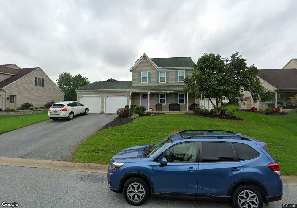
1034 Whitemarsh Dr Lancaster, PA 17601
Landis Valley NeighborhoodEstimated Value: $443,500 - $552,000
3
Beds
2
Baths
1,815
Sq Ft
$276/Sq Ft
Est. Value
About This Home
This home is located at 1034 Whitemarsh Dr, Lancaster, PA 17601 and is currently estimated at $500,375, approximately $275 per square foot. 1034 Whitemarsh Dr is a home located in Lancaster County with nearby schools including Nitrauer School, Landis Run Intermediate School, and Manheim Township Middle School.
Ownership History
Date
Name
Owned For
Owner Type
Purchase Details
Closed on
Aug 28, 1996
Bought by
Yeingst James M and Beth Anne
Current Estimated Value
Create a Home Valuation Report for This Property
The Home Valuation Report is an in-depth analysis detailing your home's value as well as a comparison with similar homes in the area
Home Values in the Area
Average Home Value in this Area
Purchase History
| Date | Buyer | Sale Price | Title Company |
|---|---|---|---|
| Yeingst James M | $136,300 | -- |
Source: Public Records
Tax History Compared to Growth
Tax History
| Year | Tax Paid | Tax Assessment Tax Assessment Total Assessment is a certain percentage of the fair market value that is determined by local assessors to be the total taxable value of land and additions on the property. | Land | Improvement |
|---|---|---|---|---|
| 2025 | $5,195 | $240,100 | $65,500 | $174,600 |
| 2024 | $5,195 | $240,100 | $65,500 | $174,600 |
| 2023 | $5,060 | $240,100 | $65,500 | $174,600 |
| 2022 | $4,974 | $240,100 | $65,500 | $174,600 |
| 2021 | $4,863 | $240,100 | $65,500 | $174,600 |
| 2020 | $4,863 | $240,100 | $65,500 | $174,600 |
| 2019 | $4,816 | $240,100 | $65,500 | $174,600 |
| 2018 | $5,848 | $240,100 | $65,500 | $174,600 |
| 2017 | $4,321 | $169,800 | $56,000 | $113,800 |
| 2016 | $4,321 | $169,800 | $56,000 | $113,800 |
| 2015 | $1,086 | $169,800 | $56,000 | $113,800 |
| 2014 | $3,057 | $169,800 | $56,000 | $113,800 |
Source: Public Records
Map
Nearby Homes
- 2475 Oregon Pike
- 1041 Hunsicker Rd
- 1012 Whitfield Dr
- 2524 Saddle Dr
- 71 Valleybrook Dr Unit 71
- 212 Greenview Dr Unit T2212
- 202 Valleybrook Dr Unit 202
- 2635 Beechwood Rd
- 0 Butter Rd
- 0 Butter Rd
- 441 Valleybrook Dr
- 1217 Hunsicker Rd
- 8 Ponderosa Dr
- 605 Kincaid Ave
- 672 Stockdale Dr
- 539 Sierra Ln
- 548 E Delp Rd
- 571 Laurel Ln
- 2442 Stone Heath Dr
- 2111 Landis Valley Rd
- 1038 Whitemarsh Dr
- 1030 Whitemarsh Dr
- 1034 Roesser Dr
- 1038 Roesser Dr
- 1042 Whitemarsh Dr
- 1026 Whitemarsh Dr
- 1030 Roesser Dr
- 1039 Whitemarsh Dr
- 1035 Whitemarsh Dr
- 1031 Whitemarsh Dr
- 2458 Carriage Dr
- 1026 Roesser Dr
- 1042 Roesser Dr
- 1046 Whitemarsh Dr
- 1022 Whitemarsh Dr
- 1027 Whitemarsh Dr
- 1022 Roesser Dr
- 1029 Roesser Dr
- 1050 Whitemarsh Dr
- 1033 Roesser Dr