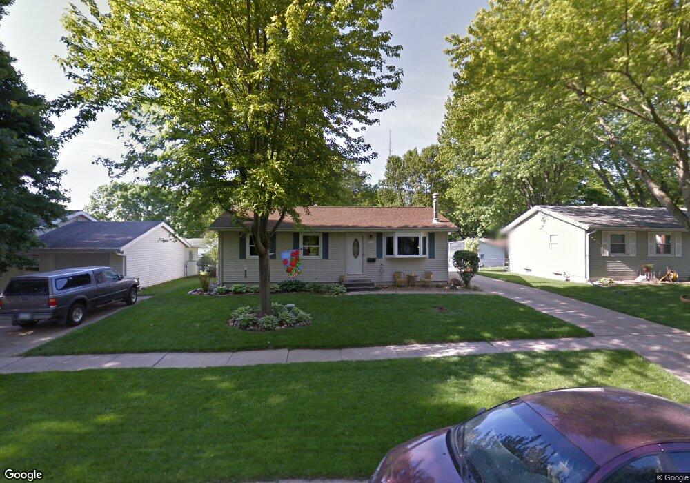
1035 W 9th Ave Marion, IA 52302
Estimated Value: $180,000 - $200,000
3
Beds
2
Baths
912
Sq Ft
$207/Sq Ft
Est. Value
About This Home
This home is located at 1035 W 9th Ave, Marion, IA 52302 and is currently estimated at $188,551, approximately $206 per square foot. 1035 W 9th Ave is a home located in Linn County with nearby schools including Novak Elementary School, Oak Ridge School, and Linn-Mar High School.
Ownership History
Date
Name
Owned For
Owner Type
Purchase Details
Closed on
Sep 30, 2009
Sold by
Usher Christopher P and Lumm Usher Lauri
Bought by
Seitz Deborah A
Current Estimated Value
Home Financials for this Owner
Home Financials are based on the most recent Mortgage that was taken out on this home.
Original Mortgage
$98,160
Outstanding Balance
$64,326
Interest Rate
5.15%
Mortgage Type
New Conventional
Estimated Equity
$124,225
Purchase Details
Closed on
Feb 1, 2005
Sold by
Usher Christopher P
Bought by
Lumm Usher Lauri
Home Financials for this Owner
Home Financials are based on the most recent Mortgage that was taken out on this home.
Original Mortgage
$100,400
Interest Rate
5.75%
Mortgage Type
New Conventional
Purchase Details
Closed on
Mar 12, 2002
Sold by
Usher Donald J and Usher Lucille M
Bought by
Usher Christopher P
Home Financials for this Owner
Home Financials are based on the most recent Mortgage that was taken out on this home.
Original Mortgage
$105,000
Interest Rate
7.11%
Create a Home Valuation Report for This Property
The Home Valuation Report is an in-depth analysis detailing your home's value as well as a comparison with similar homes in the area
Home Values in the Area
Average Home Value in this Area
Purchase History
| Date | Buyer | Sale Price | Title Company |
|---|---|---|---|
| Seitz Deborah A | $122,500 | None Available | |
| Lumm Usher Lauri | -- | A Title Escrow Co Inc | |
| Usher Christopher P | $89,500 | -- |
Source: Public Records
Mortgage History
| Date | Status | Borrower | Loan Amount |
|---|---|---|---|
| Open | Seitz Deborah A | $98,160 | |
| Previous Owner | Lumm Usher Lauri | $100,400 | |
| Previous Owner | Usher Christopher P | $105,000 |
Source: Public Records
Tax History Compared to Growth
Tax History
| Year | Tax Paid | Tax Assessment Tax Assessment Total Assessment is a certain percentage of the fair market value that is determined by local assessors to be the total taxable value of land and additions on the property. | Land | Improvement |
|---|---|---|---|---|
| 2025 | $2,942 | $184,000 | $18,100 | $165,900 |
| 2024 | $2,932 | $173,900 | $18,100 | $155,800 |
| 2023 | $2,932 | $173,900 | $18,100 | $155,800 |
| 2022 | $2,792 | $141,000 | $18,100 | $122,900 |
| 2021 | $2,690 | $141,000 | $18,100 | $122,900 |
| 2020 | $2,690 | $128,000 | $18,100 | $109,900 |
| 2019 | $2,542 | $121,200 | $18,100 | $103,100 |
| 2018 | $2,440 | $121,200 | $18,100 | $103,100 |
| 2017 | $2,356 | $114,600 | $18,100 | $96,500 |
| 2016 | $2,474 | $114,600 | $18,100 | $96,500 |
| 2015 | $2,465 | $114,600 | $18,100 | $96,500 |
| 2014 | $2,278 | $114,600 | $18,100 | $96,500 |
| 2013 | $2,170 | $114,600 | $18,100 | $96,500 |
Source: Public Records
Map
Nearby Homes
- 1125 W 10th Ave
- 1065 W 10th Ave
- 915 W 10th Ave
- 1195 Lindale Dr
- 655 W 9th Ave
- 1145 Blairs Ferry Rd
- 201 Brentwood Dr NE
- 117 Brentwood Dr NE
- 221 Brentwood Dr NE
- 179 Crandall Dr NE
- 1013 Blairs Ferry R
- 1032 Archer Dr
- 823 Flight Dr
- 1074 Archer Dr
- 840 Longbow Ct
- 1080 Everdeen Ct
- 1089 Archer Dr
- 201 Teakwood Ln NE
- 2010 Newcastle Rd
- 785 Bowstring Dr