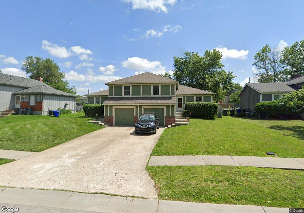
1035 W Sheridan St Olathe, KS 66061
Estimated Value: $349,000 - $456,000
4
Beds
4
Baths
1,776
Sq Ft
$217/Sq Ft
Est. Value
About This Home
This home is located at 1035 W Sheridan St, Olathe, KS 66061 and is currently estimated at $384,813, approximately $216 per square foot. 1035 W Sheridan St is a home located in Johnson County with nearby schools including Rolling Ridge Elementary School, Oregon Trail Middle School, and Olathe West High School.
Ownership History
Date
Name
Owned For
Owner Type
Purchase Details
Closed on
Aug 23, 2019
Sold by
Schoenberg Land Co Llc
Bought by
Shivaram Gampala and Eluganti Abhyudaya Reddy
Current Estimated Value
Purchase Details
Closed on
Dec 29, 2017
Sold by
Grimes Leslie I
Bought by
Schoenberg Land Co Llc
Purchase Details
Closed on
Aug 10, 2007
Sold by
Grimes Leslie I
Bought by
Grimes Alayna J and Crowley Michael M
Create a Home Valuation Report for This Property
The Home Valuation Report is an in-depth analysis detailing your home's value as well as a comparison with similar homes in the area
Home Values in the Area
Average Home Value in this Area
Purchase History
| Date | Buyer | Sale Price | Title Company |
|---|---|---|---|
| Shivaram Gampala | -- | Continental Title Company | |
| Schoenberg Land Co Llc | -- | Clear Title | |
| Grimes Alayna J | -- | None Available |
Source: Public Records
Tax History Compared to Growth
Tax History
| Year | Tax Paid | Tax Assessment Tax Assessment Total Assessment is a certain percentage of the fair market value that is determined by local assessors to be the total taxable value of land and additions on the property. | Land | Improvement |
|---|---|---|---|---|
| 2024 | $4,810 | $42,791 | $5,974 | $36,817 |
| 2023 | $4,672 | $40,756 | $5,435 | $35,321 |
| 2022 | $4,240 | $36,007 | $4,727 | $31,280 |
| 2021 | $3,794 | $30,717 | $4,727 | $25,990 |
| 2020 | $3,610 | $28,980 | $4,301 | $24,679 |
| 2019 | $2,740 | $21,931 | $4,301 | $17,630 |
| 2018 | $2,597 | $20,654 | $4,301 | $16,353 |
| 2017 | $2,336 | $18,423 | $3,583 | $14,840 |
| 2016 | $2,201 | $17,813 | $3,261 | $14,552 |
| 2015 | $2,022 | $16,399 | $3,261 | $13,138 |
| 2013 | -- | $14,513 | $3,261 | $11,252 |
Source: Public Records
Map
Nearby Homes
- 1106 W Sheridan St
- 1200 W Sheridan St
- 812 S Troost St
- 531 S Oscar St
- 617 S Grant St
- 600 W Elm St
- 573 W Loula St
- 1604 W Cedar St
- 1545 W Park St
- 233 S Chambery Dr
- 1952 W Ferrel Dr
- 507 W Park St
- 1425 W Poplar St
- 706 S Kansas Ave
- 1947 W Oak St
- 990 S Cedar Hills St
- 721 S Chestnut St
- 1952 W Fredrickson Cir
- 109 E Cedar St
- 335 S Water St
- 1037 W Sheridan St
- 1029 W Sheridan St
- 1101 W Sheridan St
- 1107 W Sheridan St
- 1022 W Virginia Ln
- 1020 W Virginia Ln
- 1017 W Sheridan St
- 1109 W Sheridan St
- 1023 W Sheridan St
- 1018 W Virginia Ln
- 1032 W Sheridan St
- 1100 W Sheridan St
- 1030 W Sheridan St
- 1102 W Sheridan St
- 1016 W Virginia Ln
- 1113 W Sheridan St
- 1026 W Sheridan St
- 1014 W Virginia Ln
- 1024 W Sheridan St
- 1108 W Sheridan St