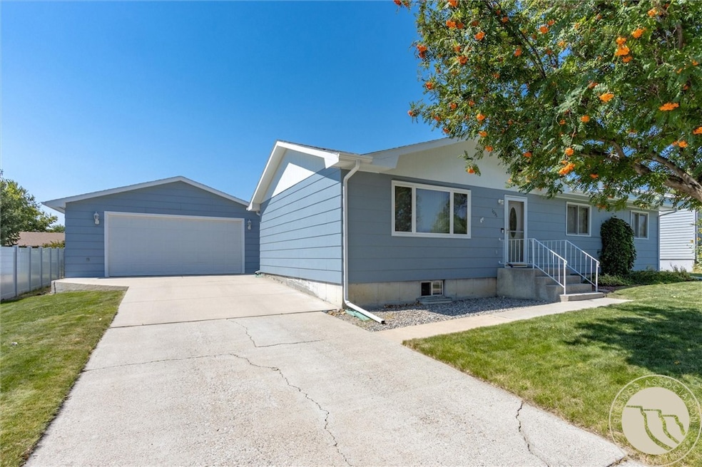
1036 9th Ave Laurel, MT 59044
Estimated payment $2,146/month
Highlights
- 1 Fireplace
- Interior Lot
- Patio
- 2 Car Detached Garage
- Cooling Available
- Shed
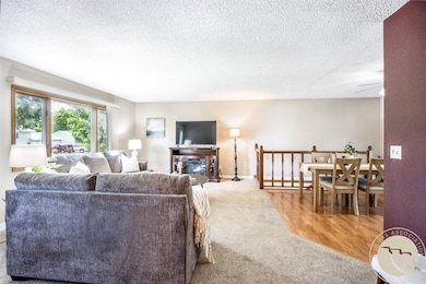
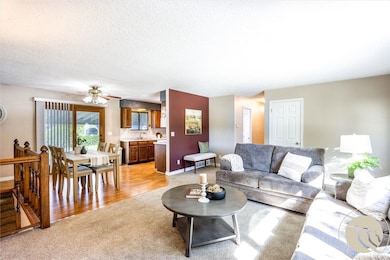
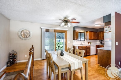
About This Home
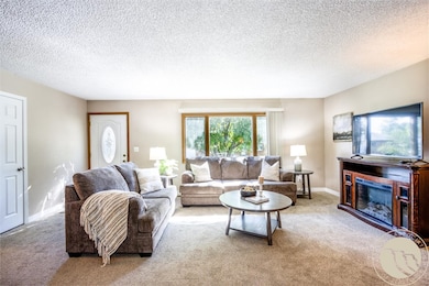
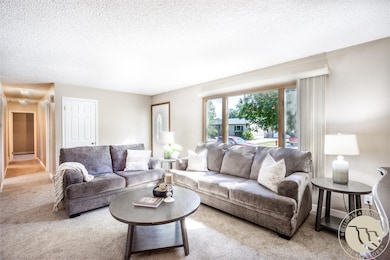
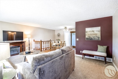
Freshly updated and move-in ready! This 4-bedroom, 3-bath Northwest Laurel home offers 2,400 sq. ft., a spacious master suite, an inviting floor plan, and a backyard designed for summer fun — all in a quiet, convenient neighborhood. The main level features an inviting living room and a sun-filled dining area that opens to the patio — perfect for BBQs and gatherings in the fenced yard. You’ll also find the master suite and two additional bedrooms upstairs. The lower level offers a cozy family room with a fireplace, a fourth bedroom, and a full bathroom — ideal for guests or movie nights. A 2-car garage and extra storage shed provide plenty of room for hobbies, tools, or outdoor gear. Close to schools, parks, and all Laurel amenities, this home combines peaceful neighborhood living with easy access to town.
Listing Agent
Meridian Real Estate LLC Brokerage Phone: 406-855-5725 License #RRE-BRO-LIC-7063434 Listed on: 08/08/2025
Home Details
Home Type
- Single Family
Est. Annual Taxes
- $2,850
Year Built
- Built in 1978
Lot Details
- 8,000 Sq Ft Lot
- Fenced
- Landscaped
- Interior Lot
- Zoning described as Residential 7500
Parking
- 2 Car Detached Garage
- Alley Access
Home Design
- Asphalt Roof
- Masonite
Interior Spaces
- 2,400 Sq Ft Home
- 1-Story Property
- 1 Fireplace
- Basement Fills Entire Space Under The House
Kitchen
- Oven
- Electric Range
- Microwave
- Dishwasher
Bedrooms and Bathrooms
- 4 Bedrooms | 3 Main Level Bedrooms
- 3 Full Bathrooms
Outdoor Features
- Patio
- Shed
Schools
- Laurel Elementary And Middle School
- Laurel High School
Utilities
- Cooling Available
- Forced Air Heating System
Community Details
- Cherry Hills Subd Subdivision
Listing and Financial Details
- Assessor Parcel Number B02252
Map
Home Values in the Area
Average Home Value in this Area
Tax History
| Year | Tax Paid | Tax Assessment Tax Assessment Total Assessment is a certain percentage of the fair market value that is determined by local assessors to be the total taxable value of land and additions on the property. | Land | Improvement |
|---|---|---|---|---|
| 2025 | $2,851 | $374,600 | $74,228 | $300,372 |
| 2024 | $2,851 | $296,600 | $68,037 | $228,563 |
| 2023 | $2,623 | $296,600 | $68,037 | $228,563 |
| 2022 | $2,420 | $261,300 | $0 | $0 |
| 2021 | $2,441 | $261,300 | $0 | $0 |
| 2020 | $2,253 | $235,600 | $0 | $0 |
| 2019 | $2,220 | $235,600 | $0 | $0 |
| 2018 | $2,173 | $216,200 | $0 | $0 |
| 2017 | $2,016 | $216,200 | $0 | $0 |
| 2016 | $1,829 | $195,900 | $0 | $0 |
| 2015 | $1,807 | $195,900 | $0 | $0 |
| 2014 | $1,672 | $94,817 | $0 | $0 |
Property History
| Date | Event | Price | List to Sale | Price per Sq Ft |
|---|---|---|---|---|
| 10/28/2025 10/28/25 | Price Changed | $364,900 | -1.4% | $152 / Sq Ft |
| 09/09/2025 09/09/25 | Price Changed | $369,900 | -1.1% | $154 / Sq Ft |
| 08/20/2025 08/20/25 | Price Changed | $374,000 | -1.3% | $156 / Sq Ft |
| 08/08/2025 08/08/25 | For Sale | $379,000 | -- | $158 / Sq Ft |
Purchase History
| Date | Type | Sale Price | Title Company |
|---|---|---|---|
| Warranty Deed | -- | None Available |
Mortgage History
| Date | Status | Loan Amount | Loan Type |
|---|---|---|---|
| Open | $127,893 | FHA |
Source: Billings Multiple Listing Service
MLS Number: 354828
APN: 03-0821-08-1-21-06-0000
Disclaimer: Certain information contained herein is derived from information provided by parties other than Homes.com. All information provided is deemed reliable, but is not guaranteed to be accurate and should be independently verified.
![]() IDX information is provided exclusively for personal, non-commercial use, and may not be used for any purpose other than to identify prospective properties consumers may be interested in purchasing. Information is deemed reliable but not guaranteed.
IDX information is provided exclusively for personal, non-commercial use, and may not be used for any purpose other than to identify prospective properties consumers may be interested in purchasing. Information is deemed reliable but not guaranteed.
- 1109 10th Ave
- 1106 W 12th St
- 1013 W 12th St
- TBD Block 3 Lot 9
- TBD Block 1 Lot 3
- 1014 Rochelle Ln
- TBD Block 3 Lot 4
- 512 W 14th St
- TBD Block 3 Lot 6
- 109 E 12th St
- 1003 Montana Ave
- 1018 Els Dr
- 102 8th Ave Unit B
- 110 E 5th St
- 116 4th Ave
- 1712 Paynes Place
- 516 Pennsylvania Ave
- 208 West Ave
- 1960 Coyote Ridge Rd N
- 301 West Ave
- 519 E 6th St
- 4623 King Ave W
- 1015 Final Four Way
- 4510 Gators Way
- 4402 Blue Devils Way
- 920 Malibu Way
- 610 S 44th St W
- 4215 Montana Sapphire Dr
- 4301 King Ave W
- 610 S 44th St W
- 501 S 44th St W
- 4427 Altay Dr
- 4411 Dacha Dr
- 485 S 44th St W
- 6309 Beckville Ln
- 3900 Victory Cir
- 3624 Spartan Cir
- 115 Shiloh Rd
- 3290 Granger Ave E
- 3227 Lynn Ave
