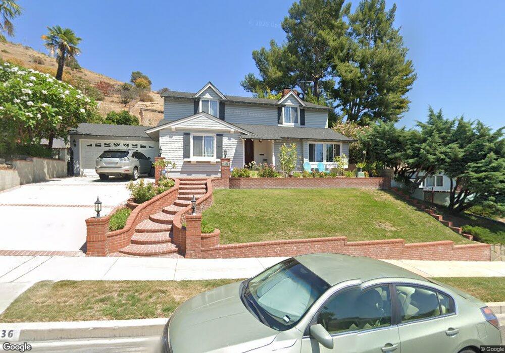
1036 Bethany Rd Burbank, CA 91504
Hillside District NeighborhoodEstimated Value: $1,620,000 - $2,136,000
4
Beds
3
Baths
2,429
Sq Ft
$756/Sq Ft
Est. Value
About This Home
This home is located at 1036 Bethany Rd, Burbank, CA 91504 and is currently estimated at $1,835,283, approximately $755 per square foot. 1036 Bethany Rd is a home located in Los Angeles County with nearby schools including Thomas Jefferson Elementary School, John Muir Middle School, and Burbank High School.
Ownership History
Date
Name
Owned For
Owner Type
Purchase Details
Closed on
Oct 8, 2016
Sold by
Sedhom Sarwat Mikhail
Bought by
Sedhom Sarwat M and Sedhom Janet N
Current Estimated Value
Purchase Details
Closed on
Feb 22, 1995
Sold by
Manor Fund
Bought by
Sedhom Sarwat Mikhail
Home Financials for this Owner
Home Financials are based on the most recent Mortgage that was taken out on this home.
Original Mortgage
$173,700
Interest Rate
9.03%
Create a Home Valuation Report for This Property
The Home Valuation Report is an in-depth analysis detailing your home's value as well as a comparison with similar homes in the area
Home Values in the Area
Average Home Value in this Area
Purchase History
| Date | Buyer | Sale Price | Title Company |
|---|---|---|---|
| Sedhom Sarwat M | -- | None Available | |
| Sedhom Sarwat Mikhail | $289,500 | -- |
Source: Public Records
Mortgage History
| Date | Status | Borrower | Loan Amount |
|---|---|---|---|
| Closed | Sedhom Sarwat Mikhail | $173,700 |
Source: Public Records
Tax History
| Year | Tax Paid | Tax Assessment Tax Assessment Total Assessment is a certain percentage of the fair market value that is determined by local assessors to be the total taxable value of land and additions on the property. | Land | Improvement |
|---|---|---|---|---|
| 2025 | $5,488 | $486,247 | $296,959 | $189,288 |
| 2024 | $5,488 | $476,714 | $291,137 | $185,577 |
| 2023 | $5,431 | $467,368 | $285,429 | $181,939 |
| 2022 | $5,188 | $458,205 | $279,833 | $178,372 |
| 2021 | $5,156 | $449,222 | $274,347 | $174,875 |
| 2019 | $4,950 | $435,899 | $266,210 | $169,689 |
| 2018 | $4,863 | $427,353 | $260,991 | $166,362 |
| 2016 | $4,599 | $410,759 | $250,857 | $159,902 |
| 2015 | $4,507 | $404,590 | $247,089 | $157,501 |
| 2014 | $4,502 | $396,665 | $242,249 | $154,416 |
Source: Public Records
Map
Nearby Homes
- 1083 E Fairmount Rd
- 902 E Walnut Ave
- 718 E Walnut Ave
- 1025 E San Jose Ave
- 1819 Richard St
- 610 E Harvard Rd Unit 7
- 815 E Magnolia Blvd
- 900 E Palm Ave
- 505 Cambridge Dr
- 615 E Magnolia Blvd
- 0 Country Club Dr Unit SB24168055
- 2031 Jolley Dr
- 441 Dartmouth Rd
- 441 E San Jose Ave Unit 111
- 701 Country Club Dr
- 456 E San Jose Ave Unit L
- 230 Bethany Rd Unit 124
- 330 N 5th St
- 660 Country Club Dr
- 621 E Olive Ave Unit 106
- 1042 Bethany Rd
- 1030 Bethany Rd
- 1048 Bethany Rd
- 1024 Bethany Rd
- 1033 Cornell Dr
- 1054 Bethany Rd
- 1030 Amherst Dr
- 1025 Bethany Rd
- 1025 Cornell Dr
- 1039 Amherst Dr
- 1018 Bethany Rd
- 1037 Cornell Dr
- 1146 N Sunset Canyon Dr
- 1053 Bethany Rd
- 1019 Bethany Rd
- 1019 Cornell Dr
- 1012 Bethany Rd
- 1024 Amherst Dr
- 1060 Bethany Rd
- 1041 Cornell Dr
Your Personal Tour Guide
Ask me questions while you tour the home.