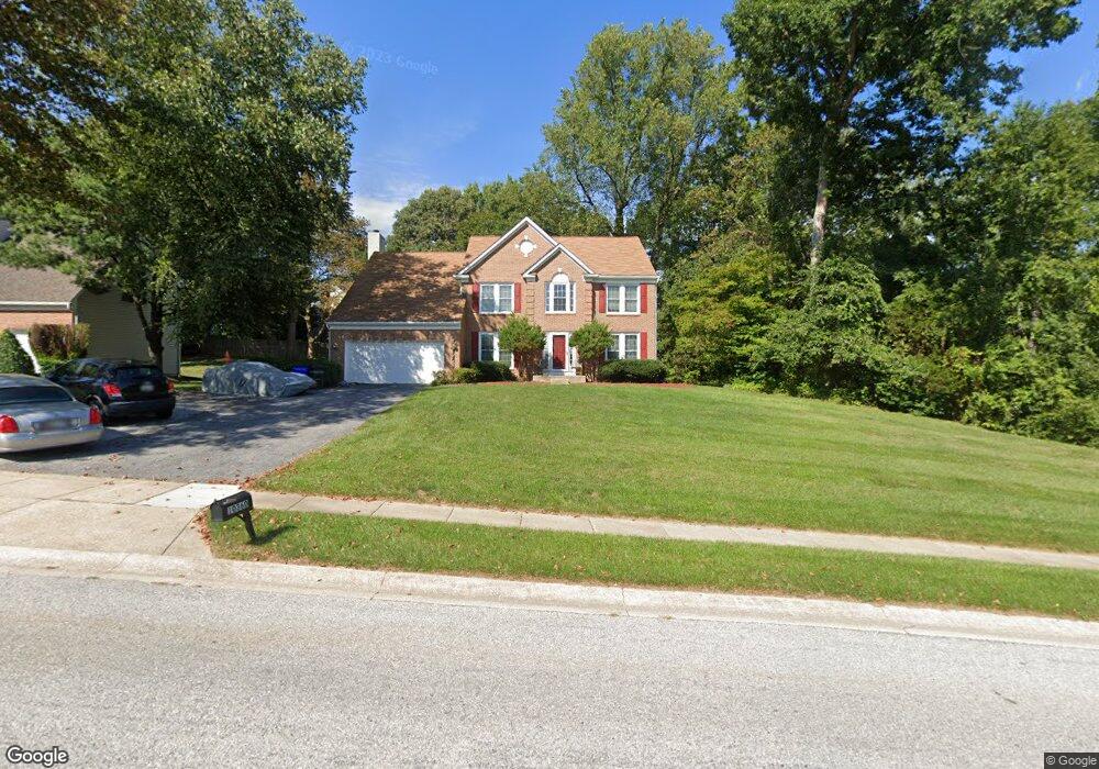
10360 Stansfield Rd Laurel, MD 20723
Estimated Value: $687,000 - $866,000
Studio
4
Baths
2,810
Sq Ft
$285/Sq Ft
Est. Value
About This Home
This home is located at 10360 Stansfield Rd, Laurel, MD 20723 and is currently estimated at $802,054, approximately $285 per square foot. 10360 Stansfield Rd is a home located in Howard County with nearby schools including Hammond Elementary School, Hammond Middle School, and Reservoir High School.
Ownership History
Date
Name
Owned For
Owner Type
Purchase Details
Closed on
Jun 25, 1992
Sold by
Ryan Operations G P
Bought by
Whitney Mark and Whitney Sheila E
Current Estimated Value
Home Financials for this Owner
Home Financials are based on the most recent Mortgage that was taken out on this home.
Original Mortgage
$238,500
Interest Rate
8.48%
Purchase Details
Closed on
Mar 3, 1992
Sold by
J J M Inc
Bought by
Ryan Operations G P
Home Financials for this Owner
Home Financials are based on the most recent Mortgage that was taken out on this home.
Original Mortgage
$263,725
Interest Rate
8.83%
Create a Home Valuation Report for This Property
The Home Valuation Report is an in-depth analysis detailing your home's value as well as a comparison with similar homes in the area
Home Values in the Area
Average Home Value in this Area
Purchase History
| Date | Buyer | Sale Price | Title Company |
|---|---|---|---|
| Whitney Mark | $265,000 | -- | |
| Ryan Operations G P | $72,500 | -- |
Source: Public Records
Mortgage History
| Date | Status | Borrower | Loan Amount |
|---|---|---|---|
| Closed | Whitney Mark | $238,500 | |
| Previous Owner | Ryan Operations G P | $263,725 |
Source: Public Records
Tax History
| Year | Tax Paid | Tax Assessment Tax Assessment Total Assessment is a certain percentage of the fair market value that is determined by local assessors to be the total taxable value of land and additions on the property. | Land | Improvement |
|---|---|---|---|---|
| 2025 | $9,936 | $690,600 | $251,100 | $439,500 |
| 2024 | $9,936 | $656,167 | $0 | $0 |
| 2023 | $9,326 | $621,733 | $0 | $0 |
| 2022 | $8,854 | $587,300 | $221,100 | $366,200 |
| 2021 | $8,805 | $574,133 | $0 | $0 |
| 2020 | $8,805 | $560,967 | $0 | $0 |
| 2019 | $8,616 | $547,800 | $234,000 | $313,800 |
| 2018 | $8,215 | $547,800 | $234,000 | $313,800 |
| 2017 | $8,187 | $547,800 | $0 | $0 |
| 2016 | -- | $553,500 | $0 | $0 |
| 2015 | -- | $537,033 | $0 | $0 |
| 2014 | -- | $520,567 | $0 | $0 |
Source: Public Records
Map
Nearby Homes
- 9890 Deer Run
- 8616 Doves Fly Way
- 7209 Brooklyn Bridge Rd
- 9437 Fairview Ave
- 9429 Fairview Ave
- 10571 Scaggsville Rd
- 7106 Donston Dr
- 9425 Fairview Ave
- 16140 Kenny Rd
- 1211 Snowden Place
- 9401 Riverbrink Ct
- 9711 Whiskey Run
- 9342 Canterbury Riding
- 15743 Millbrook Ln
- 1116 Westview Terrace
- 8040 Sandy Spring Rd
- 15706 Dorset Rd Unit 102
- 15708 Dorset Rd Unit 202
- 1016 Phillip Powers Dr
- 910 Montgomery St Unit A
- 10364 Stansfield Rd
- 10320 Stansfield Rd
- 10324 Stansfield Rd
- 8819 Bluebird Trace
- 8823 Bluebird Trace
- 10368 Stansfield Rd
- 10305 Stansfield Rd
- 8816 Bluebird Trace
- 8815 Bluebird Trace
- 8818 Cardinal Ct
- 8822 Cardinal Ct
- 8810 Bluebird Trace
- 9050 Dumhart Rd
- 8811 Bluebird Trace
- 8814 Cardinal Ct
- 10295 Stansfield Rd
- 10311 Stansfield Rd
- 8825 Cardinal Ct
- 9030 Dumhart Rd
- 8806 Bluebird Trace
Your Personal Tour Guide
Ask me questions while you tour the home.