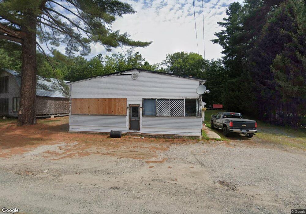
1037 Lancaster Rd Lancaster, NH 03584
Estimated Value: $140,486 - $292,000
3
Beds
2
Baths
1,440
Sq Ft
$155/Sq Ft
Est. Value
About This Home
This home is located at 1037 Lancaster Rd, Lancaster, NH 03584 and is currently estimated at $223,372, approximately $155 per square foot. 1037 Lancaster Rd is a home located in Coos County with nearby schools including Groveton Elementary School, Groveton High School, and North Country Charter Academy Lancaster (M).
Ownership History
Date
Name
Owned For
Owner Type
Purchase Details
Closed on
Sep 1, 2005
Sold by
Steady Silance G and Steady Angie L
Bought by
Perkins Dana W and Perkins Rachel S
Current Estimated Value
Home Financials for this Owner
Home Financials are based on the most recent Mortgage that was taken out on this home.
Original Mortgage
$87,849
Interest Rate
5.81%
Create a Home Valuation Report for This Property
The Home Valuation Report is an in-depth analysis detailing your home's value as well as a comparison with similar homes in the area
Home Values in the Area
Average Home Value in this Area
Purchase History
| Date | Buyer | Sale Price | Title Company |
|---|---|---|---|
| Perkins Dana W | $86,000 | -- |
Source: Public Records
Mortgage History
| Date | Status | Borrower | Loan Amount |
|---|---|---|---|
| Open | Perkins Dana W | $87,849 | |
| Closed | Perkins Dana W | $87,849 |
Source: Public Records
Tax History Compared to Growth
Tax History
| Year | Tax Paid | Tax Assessment Tax Assessment Total Assessment is a certain percentage of the fair market value that is determined by local assessors to be the total taxable value of land and additions on the property. | Land | Improvement |
|---|---|---|---|---|
| 2024 | $2,577 | $114,860 | $55,600 | $59,260 |
| 2023 | $2,456 | $114,860 | $55,600 | $59,260 |
| 2022 | $1,922 | $58,130 | $20,000 | $38,130 |
| 2021 | $2,053 | $58,130 | $20,000 | $38,130 |
| 2020 | $1,919 | $58,130 | $20,000 | $38,130 |
| 2019 | $1,886 | $58,130 | $20,000 | $38,130 |
| 2018 | $1,887 | $58,450 | $20,000 | $38,450 |
| 2016 | $2,377 | $64,600 | $20,000 | $44,600 |
| 2015 | $2,241 | $64,600 | $20,000 | $44,600 |
| 2013 | $2,156 | $64,400 | $20,000 | $44,400 |
Source: Public Records
Map
Nearby Homes
- 300 Ridgwell Ln
- 8 Sunset Ct
- 35 Marietta Ln
- 109 Dean Brook Dr
- 0 North Rd Unit 5065580
- 413 Lancaster Rd
- 501 Fellows Rd
- 95 Page Hill Rd
- 36 Longview Dr
- 101 Page Hill Rd
- Lot 12 Page Hill Rd
- Lot 5 Kelsea Ave
- 10 1st St
- Lots 7 & 8 Kelsea Dr
- 0 N Main St Unit 5049939
- 5 Cubb St
- 12 High St
- 38 Riverside Dr
- 49 Middle St
- 14 Summer St
- 1041 Lancaster Rd
- 1025 Lancaster Rd
- 1034 Lancaster Rd
- 1022 Lancaster Rd
- 1050 Lancaster Rd
- 12 Old Sawmill Rd
- 1060 Lancaster Rd
- 1068 Lancaster Rd
- 1005 Lancaster Rd
- 1075 Lancaster Rd
- 55 Spruce Rd
- 1080 Lancaster Rd
- 1084 Lancaster Rd
- 23 Yell Rd
- 10 Yell Rd
- 1109 Lancaster Rd
- 21 Yell Rd
- 21 Yell Rd
- 14 Cloutier Rd
- 960 Lancaster Rd