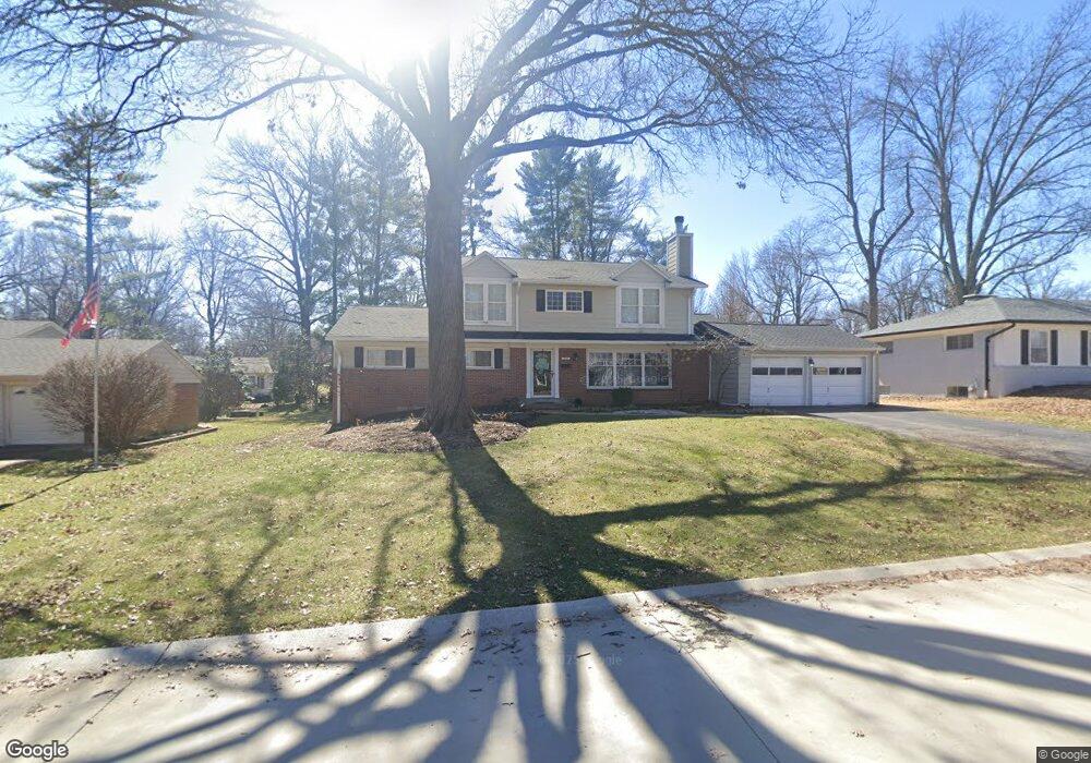
1038 Dovergate Dr Saint Louis, MO 63122
Estimated Value: $621,000 - $662,000
5
Beds
4
Baths
2,548
Sq Ft
$252/Sq Ft
Est. Value
About This Home
This home is located at 1038 Dovergate Dr, Saint Louis, MO 63122 and is currently estimated at $642,412, approximately $252 per square foot. 1038 Dovergate Dr is a home located in St. Louis County with nearby schools including W.W. Keysor Elementary School, North Kirkwood Middle School, and Kirkwood Senior High School.
Ownership History
Date
Name
Owned For
Owner Type
Purchase Details
Closed on
Apr 2, 2015
Sold by
Hogan Michael J and Hogan Colleen M
Bought by
Michael J Hogan & Colleen M Hogan Living
Current Estimated Value
Purchase Details
Closed on
Apr 4, 2001
Sold by
Boresi Arthur E & Loretto M Trustees
Bought by
Hogan Michael J and Hogan Colleen M
Home Financials for this Owner
Home Financials are based on the most recent Mortgage that was taken out on this home.
Original Mortgage
$178,400
Outstanding Balance
$66,304
Interest Rate
7.13%
Estimated Equity
$576,108
Purchase Details
Closed on
Apr 21, 1999
Sold by
Boresi Arthur E and Boresi Loretto M
Bought by
Boresi Arthur E and Boresi Loretto M
Create a Home Valuation Report for This Property
The Home Valuation Report is an in-depth analysis detailing your home's value as well as a comparison with similar homes in the area
Home Values in the Area
Average Home Value in this Area
Purchase History
| Date | Buyer | Sale Price | Title Company |
|---|---|---|---|
| Michael J Hogan & Colleen M Hogan Living | -- | None Available | |
| Hogan Michael J | $223,000 | -- | |
| Hogan Michael J | $223,000 | -- | |
| Boresi Arthur E | -- | -- |
Source: Public Records
Mortgage History
| Date | Status | Borrower | Loan Amount |
|---|---|---|---|
| Open | Hogan Michael J | $178,400 | |
| Closed | Hogan Michael J | $178,400 | |
| Closed | Hogan Michael J | $11,150 |
Source: Public Records
Tax History Compared to Growth
Tax History
| Year | Tax Paid | Tax Assessment Tax Assessment Total Assessment is a certain percentage of the fair market value that is determined by local assessors to be the total taxable value of land and additions on the property. | Land | Improvement |
|---|---|---|---|---|
| 2025 | $6,288 | $111,400 | $58,430 | $52,970 |
| 2024 | $6,288 | $100,250 | $40,170 | $60,080 |
| 2023 | $6,288 | $100,250 | $40,170 | $60,080 |
| 2022 | $6,047 | $91,380 | $40,170 | $51,210 |
| 2021 | $5,969 | $91,380 | $40,170 | $51,210 |
| 2020 | $5,666 | $83,410 | $32,360 | $51,050 |
| 2019 | $5,667 | $83,410 | $32,360 | $51,050 |
| 2018 | $4,456 | $57,840 | $26,770 | $31,070 |
| 2017 | $4,450 | $57,840 | $26,770 | $31,070 |
| 2016 | $4,382 | $57,400 | $22,970 | $34,430 |
| 2015 | $4,377 | $57,400 | $22,970 | $34,430 |
| 2014 | $5,181 | $66,530 | $15,500 | $51,030 |
Source: Public Records
Map
Nearby Homes
- 1001 Dovergate Dr
- 946 Rochdale Dr
- 919 Nana Ln
- 1422 Northlin Dr
- 11909 Lillian Ave
- 11358 Manchester Rd
- 11913 Lillian Ave
- 1003 Ormond Dr
- 546 Dougherty Ferry Rd
- 12006 Montour Dr
- 550 Bedford Oaks Dr
- 535 Kirkshire Dr
- 811 Cherry St
- 1312 W Essex Ave
- 841 N Geyer Rd
- 1710 Lynkirk Ln
- 966 N Geyer Rd
- 1126 Bopp Rd
- 603 W Essex Ave
- 896 Twin Pine Dr
- 1026 Dovergate Dr
- 1102 Dovergate Dr
- 1037 Whitecliff Dr
- 1027 Whitecliff Dr
- 1101 Whitecliff Dr
- 1045 Dovergate Dr
- 1031 Dovergate Dr
- 1012 Dovergate Dr
- 1114 Dovergate Dr
- 1103 Dovergate Dr
- 1011 Whitecliff Dr
- 1019 Dovergate Dr
- 1113 Whitecliff Dr
- 1000 Haversham Place
- 1009 Dovergate Dr
- 1122 Dovergate Dr
- 1117 Dovergate Dr
- 1028 Whitecliff Dr
- 1022 Whitecliff Dr
- 1010 Dovergate Dr