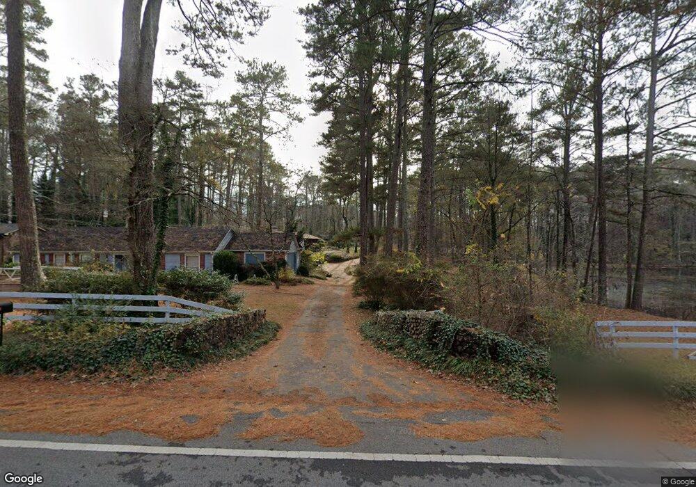
1039 Allgood Rd Stone Mountain, GA 30083
Estimated Value: $299,000 - $364,000
3
Beds
3
Baths
3,619
Sq Ft
$90/Sq Ft
Est. Value
About This Home
This home is located at 1039 Allgood Rd, Stone Mountain, GA 30083 and is currently estimated at $324,052, approximately $89 per square foot. 1039 Allgood Rd is a home located in DeKalb County with nearby schools including Allgood Elementary School, Freedom Middle School, and Clarkston High School.
Ownership History
Date
Name
Owned For
Owner Type
Purchase Details
Closed on
Dec 1, 2021
Sold by
Executor Crochet Eileen Freeman
Bought by
Freeman Edward Patrick and Freeman Kathleen Erskine
Current Estimated Value
Purchase Details
Closed on
Aug 29, 1997
Sold by
Cameron Verl L and Cameron Marie J
Bought by
Freeman Mary P
Home Financials for this Owner
Home Financials are based on the most recent Mortgage that was taken out on this home.
Original Mortgage
$96,000
Interest Rate
7.43%
Mortgage Type
New Conventional
Create a Home Valuation Report for This Property
The Home Valuation Report is an in-depth analysis detailing your home's value as well as a comparison with similar homes in the area
Home Values in the Area
Average Home Value in this Area
Purchase History
| Date | Buyer | Sale Price | Title Company |
|---|---|---|---|
| Freeman Edward Patrick | -- | -- | |
| Freeman Mary P | $120,000 | -- |
Source: Public Records
Mortgage History
| Date | Status | Borrower | Loan Amount |
|---|---|---|---|
| Previous Owner | Freeman Mary P | $96,000 |
Source: Public Records
Tax History Compared to Growth
Tax History
| Year | Tax Paid | Tax Assessment Tax Assessment Total Assessment is a certain percentage of the fair market value that is determined by local assessors to be the total taxable value of land and additions on the property. | Land | Improvement |
|---|---|---|---|---|
| 2025 | $4,043 | $82,760 | $10,080 | $72,680 |
| 2024 | $5,315 | $111,960 | $10,080 | $101,880 |
| 2023 | $5,315 | $108,400 | $10,080 | $98,320 |
| 2022 | $5,020 | $107,240 | $10,080 | $97,160 |
| 2021 | $3,203 | $65,840 | $10,080 | $55,760 |
| 2020 | $3,774 | $78,840 | $10,080 | $68,760 |
| 2019 | $3,175 | $65,200 | $10,080 | $55,120 |
| 2018 | $1,034 | $53,280 | $4,320 | $48,960 |
| 2017 | $1,266 | $20,925 | $2,511 | $18,414 |
| 2016 | $2,680 | $53,560 | $4,320 | $49,240 |
| 2014 | $842 | $11,680 | $4,320 | $7,360 |
Source: Public Records
Map
Nearby Homes
- 4447 Lake Breeze Dr
- 1010 Allgood Rd
- 4218 Durham Cir
- 4408 Redan Rd
- 1140 Allgood Rd
- 1115 Old Coach Rd
- 1051 Rowland Rd
- 4157 Autumn Hill Dr
- 1024 Oakwood Chase Cir
- 4205 Autumn Hill Dr
- 1074 Cherokee Heights
- 4255 Autumn Woods Ct Unit 2
- 747 John Alden Rd
- 1195 Indian Creek Place
- 4564 Fountainhead Dr
- 4467 Thornwood Crescent
- 1215 Sharonton Dr
- 997 Carlisle Rd Unit 1
- 1104 To Lani Farm Rd
- 4654 Hope Springs Rd
- 1053 Allgood Rd
- 4394 Lake Breeze Dr
- 4402 Lake Breeze Dr Unit 2
- 1031 Allgood Rd
- 4386 Lake Breeze Dr
- 4410 Lake Breeze Dr Unit 2
- 4376 Lake Breeze Dr Unit 2
- 1059 Allgood Rd
- 113 Valerie Woods Dr
- 1063 Allgood Rd
- 4366 Lake Breeze Dr Unit 2
- 4330 Avonridge Dr Unit 2
- 1027 Allgood Rd
- 4430 Lake Breeze Dr
- 4333 Avonridge Dr Unit 2
- 4383 Lake Breeze Dr
- 1073 Allgood Rd
- 4356 Lake Breeze Dr
- 1026 Avon Breeze Ct
- 4265 Durham Cir