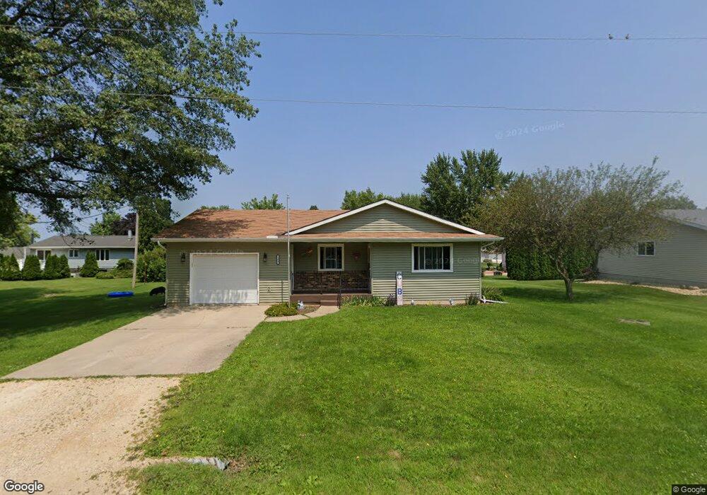
104 Center St Delmar, IA 52037
Estimated Value: $119,000 - $154,000
2
Beds
1
Bath
1,072
Sq Ft
$127/Sq Ft
Est. Value
About This Home
This home is located at 104 Center St, Delmar, IA 52037 and is currently estimated at $136,621, approximately $127 per square foot. 104 Center St is a home with nearby schools including Delwood Elementary School.
Ownership History
Date
Name
Owned For
Owner Type
Purchase Details
Closed on
Sep 11, 2024
Sold by
Lary Eugene R
Bought by
Miller Roy A
Current Estimated Value
Purchase Details
Closed on
Jun 27, 2011
Sold by
Dcrichard Wayne The Estate Of Mildred A Schne and Schneden Ex
Bought by
Mcafee Michael J and Mcafee Brenda L
Home Financials for this Owner
Home Financials are based on the most recent Mortgage that was taken out on this home.
Original Mortgage
$65,000
Interest Rate
4.67%
Mortgage Type
New Conventional
Create a Home Valuation Report for This Property
The Home Valuation Report is an in-depth analysis detailing your home's value as well as a comparison with similar homes in the area
Home Values in the Area
Average Home Value in this Area
Purchase History
| Date | Buyer | Sale Price | Title Company |
|---|---|---|---|
| Miller Roy A | $140,000 | None Listed On Document | |
| Mcafee Michael J | $65,000 | None Available |
Source: Public Records
Mortgage History
| Date | Status | Borrower | Loan Amount |
|---|---|---|---|
| Previous Owner | Mcafee Michael J | $65,000 |
Source: Public Records
Tax History Compared to Growth
Tax History
| Year | Tax Paid | Tax Assessment Tax Assessment Total Assessment is a certain percentage of the fair market value that is determined by local assessors to be the total taxable value of land and additions on the property. | Land | Improvement |
|---|---|---|---|---|
| 2025 | $1,850 | $129,850 | $12,380 | $117,470 |
| 2024 | $1,850 | $120,420 | $12,380 | $108,040 |
| 2023 | $1,820 | $120,420 | $12,380 | $108,040 |
| 2022 | $1,644 | $110,980 | $12,380 | $98,600 |
| 2021 | $1,304 | $98,960 | $15,640 | $83,320 |
| 2020 | $1,304 | $84,260 | $15,640 | $68,620 |
| 2019 | $1,194 | $79,360 | $0 | $0 |
| 2018 | $1,166 | $79,360 | $0 | $0 |
| 2017 | $1,166 | $79,360 | $0 | $0 |
| 2016 | $1,060 | $72,600 | $0 | $0 |
| 2015 | $1,060 | $72,600 | $0 | $0 |
| 2014 | $1,058 | $72,600 | $0 | $0 |
| 2013 | $1,010 | $0 | $0 | $0 |
Source: Public Records
Map
Nearby Homes
- 105 Richland St
- 2541 130th St
- 1389 260th Ave
- Lot 2 Timber Dr
- Lot 3 Timber Dr
- Lot 1 Timber Dr
- 2812 145th St
- 0 Nairn Dr Unit 153479
- 1374 290th Ave
- 108 W Monroe St
- 712 S 2nd St
- 407 S Niagara St
- 302 E Maple St
- 313 S 4th St
- 210 S 2nd St
- 706 Myatt Dr Unit A & B
- 124 E Platt St
- 310 N Dearborn St
- 2120 174th Ave
- 911 Lisa Dr