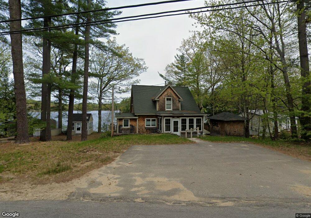
104 N Barnstead Rd Barnstead, NH 03225
Estimated Value: $583,000 - $787,794
2
Beds
2
Baths
1,615
Sq Ft
$419/Sq Ft
Est. Value
About This Home
This home is located at 104 N Barnstead Rd, Barnstead, NH 03225 and is currently estimated at $676,699, approximately $419 per square foot. 104 N Barnstead Rd is a home located in Belknap County with nearby schools including Barnstead Elementary School and Prospect Mountain High School.
Ownership History
Date
Name
Owned For
Owner Type
Purchase Details
Closed on
Feb 6, 2023
Sold by
Molino Linda
Bought by
Linda M Molino Ret
Current Estimated Value
Purchase Details
Closed on
Dec 19, 2000
Sold by
Page Charles W and Page Emma M
Bought by
Lee Gary F and Lee Joan E
Home Financials for this Owner
Home Financials are based on the most recent Mortgage that was taken out on this home.
Original Mortgage
$123,920
Interest Rate
7.7%
Create a Home Valuation Report for This Property
The Home Valuation Report is an in-depth analysis detailing your home's value as well as a comparison with similar homes in the area
Home Values in the Area
Average Home Value in this Area
Purchase History
| Date | Buyer | Sale Price | Title Company |
|---|---|---|---|
| Linda M Molino Ret | -- | None Available | |
| Lee Gary F | $159,900 | -- |
Source: Public Records
Mortgage History
| Date | Status | Borrower | Loan Amount |
|---|---|---|---|
| Previous Owner | Lee Gary F | $136,000 | |
| Previous Owner | Lee Gary F | $123,920 |
Source: Public Records
Tax History
| Year | Tax Paid | Tax Assessment Tax Assessment Total Assessment is a certain percentage of the fair market value that is determined by local assessors to be the total taxable value of land and additions on the property. | Land | Improvement |
|---|---|---|---|---|
| 2025 | $11,537 | $672,700 | $426,900 | $245,800 |
| 2024 | $10,972 | $672,700 | $426,900 | $245,800 |
| 2023 | $9,653 | $672,700 | $426,900 | $245,800 |
| 2022 | $8,197 | $379,500 | $213,300 | $166,200 |
| 2021 | $8,334 | $379,500 | $213,300 | $166,200 |
| 2020 | $8,753 | $378,900 | $213,300 | $165,600 |
| 2019 | $8,650 | $378,900 | $213,300 | $165,600 |
| 2018 | $8,431 | $378,900 | $213,300 | $165,600 |
| 2017 | $7,991 | $292,800 | $177,400 | $115,400 |
| 2016 | $7,979 | $292,800 | $177,400 | $115,400 |
| 2015 | $7,950 | $292,800 | $177,400 | $115,400 |
| 2014 | $6,891 | $287,600 | $161,500 | $126,100 |
| 2013 | $6,681 | $284,300 | $161,500 | $122,800 |
Source: Public Records
Map
Nearby Homes
- 61 Crescent Dr
- 96 Damsite Rd
- 28 Dalton Dr
- 9 W Hill Place
- 101 Rogers Rd
- 0 Andover Dr Unit 106 5059711
- 37446 N Shore Washington Dr
- 4 N Shore Dr
- 17 Prospect Mountain Rd
- 15 Davis Dr
- 1027 Suncook Valley Rd
- 58 Winwood Dr
- 4 Rustic Shores Rd
- 11b Bow Mills Rd
- Lot 33 Ridge Rd
- 147 Hamwoods Rd
- Lot 30-2-1 North Rd
- 956 N Barnstead Rd
- 25 Vail Rd
- 38 Chapelle Rd
- 110 N Barnstead Rd
- 110 N Barnstead Rd
- 114 N Barnstead Rd
- 118 N Barnstead Rd
- 86 N Barnstead Rd
- 11 Belmont Dr
- 76 Crescent Dr
- 10 Belmont Dr
- 70 Crescent Dr
- 15 Belmont Dr
- 1 Georgetown Dr
- 18 Belmont Dr
- 126 N Barnstead Rd
- 21A Crescent No Barnstead Rd
- 21A Crescent No Barnstead Rd
- 66 Crescent Dr
- 18 S Shore Dr
- 7 Georgetown Dr
- 38 South Shore
- 7 Georgetown Dr
Your Personal Tour Guide
Ask me questions while you tour the home.