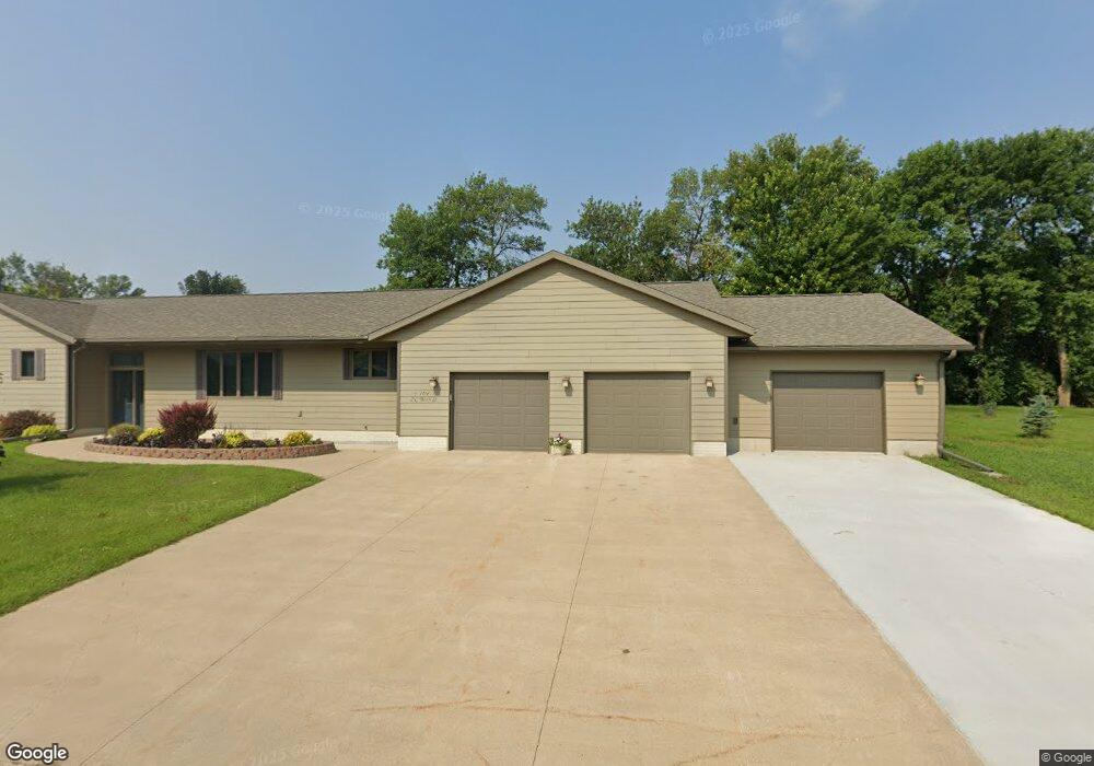
104 N Birch St George, IA 51237
Estimated Value: $282,000 - $387,000
--
Bed
1
Bath
1,714
Sq Ft
$193/Sq Ft
Est. Value
About This Home
This home is located at 104 N Birch St, George, IA 51237 and is currently estimated at $331,441, approximately $193 per square foot. 104 N Birch St is a home with nearby schools including George-Little Rock Senior High School.
Ownership History
Date
Name
Owned For
Owner Type
Purchase Details
Closed on
Jul 27, 2024
Sold by
Wynia Michael R and Wynia Mitzi J
Bought by
Doorenbos Arlen L and Doorenbos Linda R
Current Estimated Value
Purchase Details
Closed on
Sep 11, 2017
Sold by
Madsen Craig W and Madsen Tara S
Bought by
Wynia Michael R and Wynia Mitzi J
Home Financials for this Owner
Home Financials are based on the most recent Mortgage that was taken out on this home.
Original Mortgage
$190,000
Interest Rate
3.82%
Mortgage Type
New Conventional
Create a Home Valuation Report for This Property
The Home Valuation Report is an in-depth analysis detailing your home's value as well as a comparison with similar homes in the area
Home Values in the Area
Average Home Value in this Area
Purchase History
| Date | Buyer | Sale Price | Title Company |
|---|---|---|---|
| Doorenbos Arlen L | $320,000 | None Listed On Document | |
| Wynia Michael R | -- | None Available |
Source: Public Records
Mortgage History
| Date | Status | Borrower | Loan Amount |
|---|---|---|---|
| Previous Owner | Wynia Michael R | $190,000 |
Source: Public Records
Tax History Compared to Growth
Tax History
| Year | Tax Paid | Tax Assessment Tax Assessment Total Assessment is a certain percentage of the fair market value that is determined by local assessors to be the total taxable value of land and additions on the property. | Land | Improvement |
|---|---|---|---|---|
| 2025 | $5,690 | $421,190 | $26,450 | $394,740 |
| 2024 | $5,690 | $340,940 | $26,450 | $314,490 |
| 2023 | $4,528 | $341,700 | $26,450 | $315,250 |
| 2022 | $3,974 | $242,853 | $26,873 | $215,980 |
| 2021 | $3,974 | $232,180 | $19,490 | $212,690 |
| 2020 | $4,126 | $222,920 | $18,270 | $204,650 |
| 2019 | $4,164 | $220,240 | $0 | $0 |
| 2018 | $3,842 | $220,240 | $0 | $0 |
| 2017 | $3,842 | $202,180 | $0 | $0 |
| 2016 | $3,788 | $202,180 | $0 | $0 |
| 2015 | $3,788 | $183,685 | $0 | $0 |
| 2014 | $3,574 | $183,685 | $0 | $0 |
Source: Public Records
Map
Nearby Homes
- 103 S Hamilton St
- 308 W Harris Ave
- 501 S Virginia St
- 0 Kennedy Ave
- 601 E Michigan Ave
- 1998 Kennedy Ave
- 0 Kennedy Ave at 230th St
- 3726 250th St
- 4056 290th St
- 2438 Harrison Ave
- 1334 Jackson Ave
- 601 Mill Pond Rd Unit 2
- 601 Mill Pond Rd Unit 1
- 507 Mill Pond Rd
- 603 Mill Pond Rd
- 505 Mill Pond Rd Unit 2
- 505 Mill Pond Rd Unit 1
- 805 Mill Pond Rd
- 803 Mill Pond Rd
- 801 Mill Pond Rd