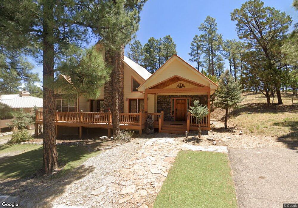
104 Walkabout Loop Unit 1 Ruidoso, NM 88345
Estimated Value: $496,000 - $729,000
3
Beds
4
Baths
2,523
Sq Ft
$226/Sq Ft
Est. Value
About This Home
This home is located at 104 Walkabout Loop Unit 1, Ruidoso, NM 88345 and is currently estimated at $570,156, approximately $225 per square foot. 104 Walkabout Loop Unit 1 is a home located in Lincoln County with nearby schools including Sierra Vista Primary School, White Mountain Elementary School, and Ruidoso Middle School.
Ownership History
Date
Name
Owned For
Owner Type
Purchase Details
Closed on
Oct 1, 2025
Sold by
Chemical Weed Control Incorporated
Bought by
Rltg Realty Llc
Current Estimated Value
Purchase Details
Closed on
Aug 3, 2009
Sold by
Rltg Realty Llc
Bought by
Chemical Weed Control Inc
Purchase Details
Closed on
Feb 17, 2009
Sold by
Wilson Darrell D and Wilson Tamara D
Bought by
Rltg Realty Llc
Purchase Details
Closed on
Jan 27, 2005
Sold by
Jasinsky Michael J and Jasinsky Cordelia M
Bought by
Wilson Darrell D and Wilson Tamara D
Home Financials for this Owner
Home Financials are based on the most recent Mortgage that was taken out on this home.
Original Mortgage
$234,000
Interest Rate
5.71%
Mortgage Type
New Conventional
Create a Home Valuation Report for This Property
The Home Valuation Report is an in-depth analysis detailing your home's value as well as a comparison with similar homes in the area
Home Values in the Area
Average Home Value in this Area
Purchase History
| Date | Buyer | Sale Price | Title Company |
|---|---|---|---|
| Rltg Realty Llc | -- | None Listed On Document | |
| Chemical Weed Control Inc | -- | None Available | |
| Rltg Realty Llc | -- | None Available | |
| Wilson Darrell D | -- | None Available |
Source: Public Records
Mortgage History
| Date | Status | Borrower | Loan Amount |
|---|---|---|---|
| Previous Owner | Wilson Darrell D | $234,000 | |
| Closed | Chemical Weed Control Inc | $0 |
Source: Public Records
Tax History Compared to Growth
Tax History
| Year | Tax Paid | Tax Assessment Tax Assessment Total Assessment is a certain percentage of the fair market value that is determined by local assessors to be the total taxable value of land and additions on the property. | Land | Improvement |
|---|---|---|---|---|
| 2025 | $4,823 | $165,218 | $16,450 | $148,768 |
| 2024 | $4,823 | $160,406 | $15,971 | $144,435 |
| 2023 | $4,823 | $155,734 | $15,506 | $140,228 |
| 2022 | $4,570 | $151,198 | $15,054 | $136,144 |
| 2021 | $4,416 | $146,781 | $14,615 | $132,166 |
| 2020 | $4,327 | $142,505 | $14,189 | $128,316 |
| 2019 | $4,049 | $139,711 | $13,911 | $125,800 |
| 2018 | $3,907 | $135,643 | $13,506 | $122,137 |
| 2017 | $3,761 | $131,692 | $13,113 | $118,579 |
| 2015 | $3,659 | $127,869 | $12,732 | $115,137 |
| 2014 | $3,659 | $127,869 | $12,732 | $115,137 |
Source: Public Records
Map
Nearby Homes
- 425 White Mountain Meadows Dr
- 110 Coker Ln
- 103 Coker Ln
- 700 Gavilan Canyon Rd
- 111 Coker Ln
- 545 White Mountain Meadows Dr
- 551 White Mountain Meadows Dr
- 116 Pat Thompson Ct
- 112 Top Side Dr
- 105 Wagon Trail
- 111 Top Side Dr
- 122 Tuscan Dr
- 143 Charles McClellan Dr
- 118 Charles McClellan Dr
- 113 Charles McClellan Dr
- 125 Top Side Dr
- 107 Pat Thompson Ct
- 104 Pat Thompson Ct
- 116 Pat Willingham Ct
- 606 White Mountain Meadows Dr
- 102 Walkabout Loop Unit 1
- 108 Walkabout Loop Unit 1
- 101 Walkabout Loop Unit 1
- 111 Meadows Dr Unit 1
- 104 Meadows Dr Unit 2
- 113 Meadows Dr
- 106 Meadows Dr Unit 2
- 400 White Mountain Meadows Dr Unit 1
- 400 White Mountain Meadows Dr
- 108 Meadows Dr Unit 2
- 108 Meadows Dr
- 408 White Mountain Meadows Dr
- 408 White Mountain Meadows Dr Unit 1
- 429 White Mountain Meadows Dr Unit 1
- 429 White Mountain Meadows Dr
- 110 Meadows Dr Unit 2
- 410 White Mountain Meadows Dr
- 427 White Mountain Meadows Dr Unit 1
- 431 White Mountain Meadows Dr
- 336 White Mountain Meadows Dr