Estimated Value: $80,964 - $99,000
2
Beds
2
Baths
1,284
Sq Ft
$73/Sq Ft
Est. Value
About This Home
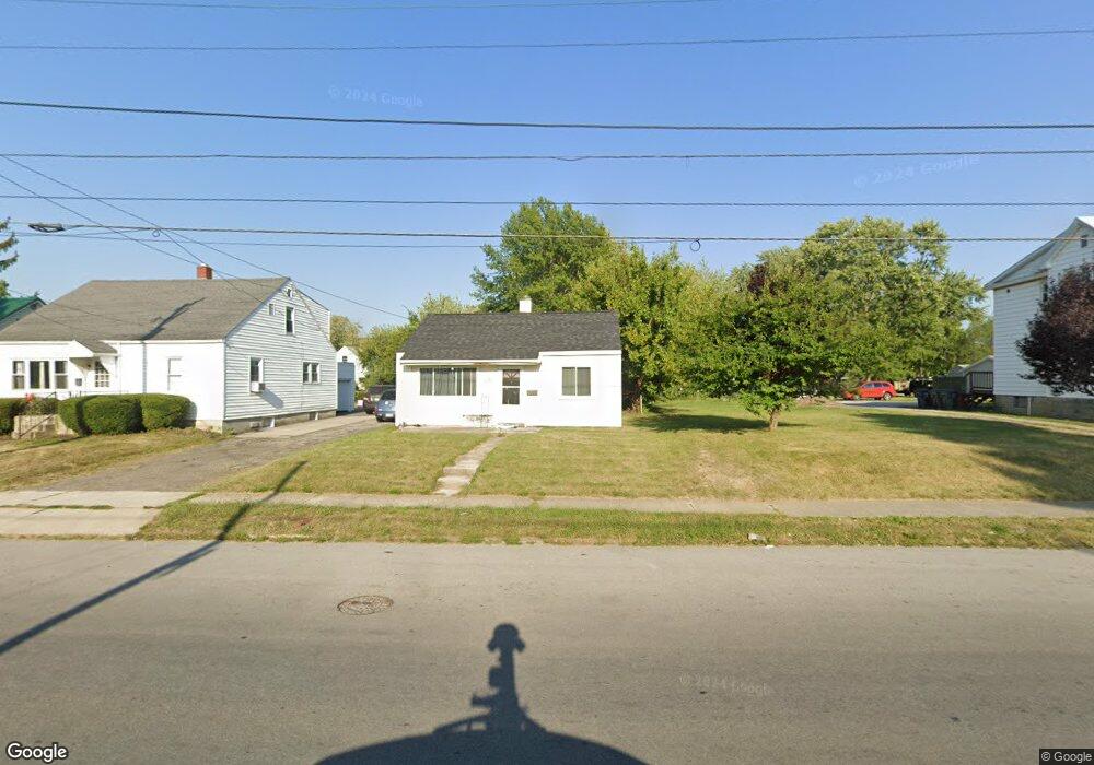
This home is located at 1040 N Main St, Lima, OH 45801 and is currently estimated at $93,491, approximately $72 per square foot. 1040 N Main St is a home located in Allen County with nearby schools including Independence Elementary School, Lima North Middle School, and Lima West Middle School.
Ownership History
Date
Name
Owned For
Owner Type
Purchase Details
Closed on
Mar 9, 2023
Sold by
Kaser Theodore K and Kaser Sharon L
Bought by
Kaser Theodore K and Kaser Sharon L
Current Estimated Value
Purchase Details
Closed on
Aug 22, 2018
Sold by
Allen County Land Reutilization Corporat
Bought by
Kaser Theodore K and Kaser Sharon L
Purchase Details
Closed on
Dec 20, 2016
Sold by
Hunter Michael and Hunter Michael L
Bought by
Allen County Land Reutilization Corp
Purchase Details
Closed on
Jun 16, 2000
Sold by
Conner William L
Bought by
Hunter Michael L
Home Financials for this Owner
Home Financials are based on the most recent Mortgage that was taken out on this home.
Original Mortgage
$19,200
Interest Rate
8.31%
Mortgage Type
New Conventional
Purchase Details
Closed on
Sep 12, 1990
Bought by
Conner William L
Create a Home Valuation Report for This Property
The Home Valuation Report is an in-depth analysis detailing your home's value as well as a comparison with similar homes in the area
Purchase History
| Date | Buyer | Sale Price | Title Company |
|---|---|---|---|
| Kaser Theodore K | -- | -- | |
| Kaser Theodore K | -- | None Available | |
| Allen County Land Reutilization Corp | -- | None Available | |
| Hunter Michael L | $24,000 | -- | |
| Conner William L | $5,900 | -- |
Source: Public Records
Mortgage History
| Date | Status | Borrower | Loan Amount |
|---|---|---|---|
| Previous Owner | Hunter Michael L | $19,200 |
Source: Public Records
Tax History
| Year | Tax Paid | Tax Assessment Tax Assessment Total Assessment is a certain percentage of the fair market value that is determined by local assessors to be the total taxable value of land and additions on the property. | Land | Improvement |
|---|---|---|---|---|
| 2024 | $614 | $25,560 | $7,740 | $17,820 |
| 2023 | $512 | $20,130 | $6,090 | $14,040 |
| 2022 | $523 | $20,130 | $6,090 | $14,040 |
| 2021 | $552 | $20,130 | $6,090 | $14,040 |
| 2020 | $496 | $17,680 | $5,880 | $11,800 |
| 2019 | $496 | $17,680 | $5,880 | $11,800 |
| 2018 | $133 | $1,160 | $1,160 | $0 |
| 2017 | $777 | $5,850 | $2,730 | $3,120 |
| 2016 | $834 | $15,470 | $2,730 | $12,740 |
| 2015 | $853 | $15,470 | $2,730 | $12,740 |
| 2014 | $865 | $15,960 | $2,660 | $13,300 |
| 2013 | $898 | $15,960 | $2,660 | $13,300 |
Source: Public Records
Map
Nearby Homes
- 919 N Main St
- 735 N Elizabeth St
- 316 Ewing Ave
- 1021 N McDonel St
- 922 N Jefferson St
- 406 Ewing Ave
- 1435 N Central Ave
- 557 W Ashton Ave
- 576 W Ashton Ave
- 608 W O'Connor Ave
- 934 N Metcalf St
- 207 W Lane Ave
- 435 Marian Ave
- 416 Hazel Ave
- 645 W O'Connor Ave
- 1212 Virginia Ave
- 514 & 516 N Elizabeth St
- 812 Christopher Dr
- 1889 N Metcalf St
- 1317 Virginia Ave
Your Personal Tour Guide
Ask me questions while you tour the home.