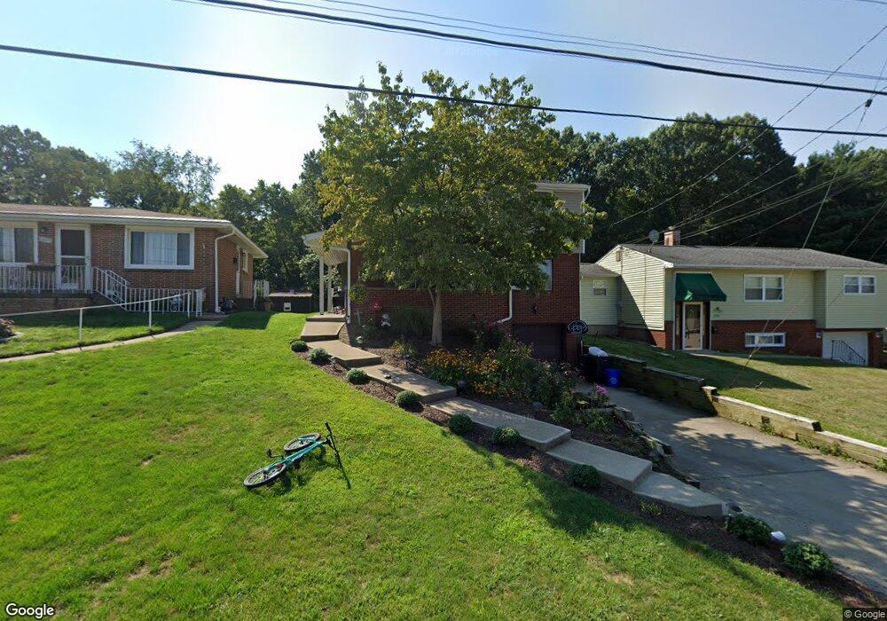
1041 Catherine Dr Conway, PA 15027
Estimated Value: $235,544 - $247,000
4
Beds
2
Baths
1,638
Sq Ft
$148/Sq Ft
Est. Value
About This Home
This home is located at 1041 Catherine Dr, Conway, PA 15027 and is currently estimated at $241,636, approximately $147 per square foot. 1041 Catherine Dr is a home located in Beaver County with nearby schools including Freedom Area Elementary School, Freedom Area Middle School, and Freedom Area Senior High School.
Ownership History
Date
Name
Owned For
Owner Type
Purchase Details
Closed on
Jul 29, 2010
Sold by
The Bank Of New York Mellon Trust Compan
Bought by
Brown Matthew S and Brown Erin M
Current Estimated Value
Home Financials for this Owner
Home Financials are based on the most recent Mortgage that was taken out on this home.
Original Mortgage
$82,400
Outstanding Balance
$54,502
Interest Rate
4.55%
Mortgage Type
New Conventional
Estimated Equity
$187,134
Purchase Details
Closed on
Nov 17, 2009
Sold by
Panzanella Frank S and Hunter Dorothy L
Bought by
The Bank Of New York Mellon Trust Compan
Create a Home Valuation Report for This Property
The Home Valuation Report is an in-depth analysis detailing your home's value as well as a comparison with similar homes in the area
Home Values in the Area
Average Home Value in this Area
Purchase History
| Date | Buyer | Sale Price | Title Company |
|---|---|---|---|
| Brown Matthew S | $103,000 | None Available | |
| The Bank Of New York Mellon Trust Compan | $3,105 | None Available |
Source: Public Records
Mortgage History
| Date | Status | Borrower | Loan Amount |
|---|---|---|---|
| Open | Brown Matthew S | $82,400 |
Source: Public Records
Tax History Compared to Growth
Tax History
| Year | Tax Paid | Tax Assessment Tax Assessment Total Assessment is a certain percentage of the fair market value that is determined by local assessors to be the total taxable value of land and additions on the property. | Land | Improvement |
|---|---|---|---|---|
| 2025 | $693 | $94,450 | $14,150 | $80,300 |
| 2024 | $3,236 | $94,450 | $14,150 | $80,300 |
| 2023 | $3,042 | $24,750 | $3,450 | $21,300 |
| 2022 | $2,955 | $24,750 | $3,450 | $21,300 |
| 2021 | $2,955 | $24,750 | $3,450 | $21,300 |
| 2020 | $2,755 | $24,750 | $3,450 | $21,300 |
| 2019 | $2,755 | $24,750 | $3,450 | $21,300 |
| 2018 | $2,648 | $24,750 | $3,450 | $21,300 |
| 2017 | $2,648 | $24,750 | $3,450 | $21,300 |
| 2016 | $2,416 | $24,750 | $3,450 | $21,300 |
| 2015 | $549 | $24,750 | $3,450 | $21,300 |
| 2014 | $549 | $24,750 | $3,450 | $21,300 |
Source: Public Records
Map
Nearby Homes
- 1040 Catherine Dr
- 1079 Catherine Dr
- 1113 Foote St
- 1304 Chaplin St
- 1001 7th Ave
- 1416 Sampson St
- 1413 Porter St
- 1421 Dupont St
- 354 11th St
- 920 4th Ave
- 1233 3rd Ave
- 1001 2nd Ave
- 1706 Foote St
- 712 Snyder St
- 744 N Gross St
- 110 13th St
- 1816 Porter St
- 328 River Ridge Ct Unit 47B
- 149 Shady River Blvd Unit 40 B
- 154 Shady River Blvd
- 1037 Catherine Dr
- 1045 Catherine Dr
- 1033 Catherine Dr
- 1049 Catherine Dr
- 1029 Catherine Dr
- 1036 Catherine Dr
- 1053 Catherine Dr
- 1032 Catherine Dr
- 1044 Catherine Dr
- 1025 Catherine Dr
- 1028 Catherine Dr
- 1057 Catherine Dr
- 1024 Catherine Dr
- 1021 Catherine Dr
- 1048 Catherine Dr
- 1059 Coral Cir
- 1020 Catherine Dr
- 1017 Catherine Dr
- 1008 Dewey St
- 1005 Dewey St