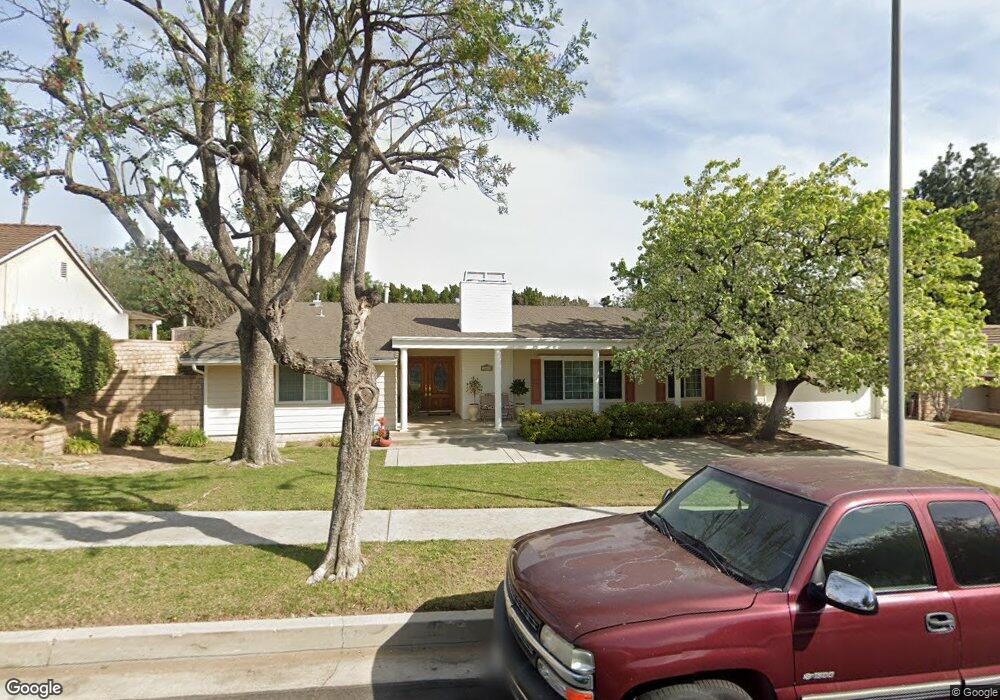
10410 Laramie Ave Chatsworth, CA 91311
Estimated Value: $1,284,035 - $1,442,000
6
Beds
3
Baths
2,940
Sq Ft
$466/Sq Ft
Est. Value
About This Home
This home is located at 10410 Laramie Ave, Chatsworth, CA 91311 and is currently estimated at $1,368,759, approximately $465 per square foot. 10410 Laramie Ave is a home located in Los Angeles County with nearby schools including Germain Academy For Academic Achievement, Ernest Lawrence Middle School, and Superior Street Elementary School.
Ownership History
Date
Name
Owned For
Owner Type
Purchase Details
Closed on
Apr 5, 1995
Sold by
Burner Alvin M and Burner Olive Y
Bought by
Thompson Jack M
Current Estimated Value
Home Financials for this Owner
Home Financials are based on the most recent Mortgage that was taken out on this home.
Original Mortgage
$100,000
Interest Rate
8.51%
Purchase Details
Closed on
Sep 7, 1993
Sold by
Burner Alvin M and Burner Olive Y
Bought by
Burner Alvin M
Create a Home Valuation Report for This Property
The Home Valuation Report is an in-depth analysis detailing your home's value as well as a comparison with similar homes in the area
Home Values in the Area
Average Home Value in this Area
Purchase History
| Date | Buyer | Sale Price | Title Company |
|---|---|---|---|
| Thompson Jack M | $360,000 | Chicago Title Insurance Co | |
| Burner Alvin M | -- | -- |
Source: Public Records
Mortgage History
| Date | Status | Borrower | Loan Amount |
|---|---|---|---|
| Closed | Thompson Jack M | $100,000 |
Source: Public Records
Tax History Compared to Growth
Tax History
| Year | Tax Paid | Tax Assessment Tax Assessment Total Assessment is a certain percentage of the fair market value that is determined by local assessors to be the total taxable value of land and additions on the property. | Land | Improvement |
|---|---|---|---|---|
| 2025 | $4,165 | $303,995 | $117,082 | $186,913 |
| 2024 | $4,165 | $298,036 | $114,787 | $183,249 |
| 2023 | $4,094 | $292,193 | $112,537 | $179,656 |
| 2022 | $3,923 | $286,465 | $110,331 | $176,134 |
| 2021 | $3,862 | $280,849 | $108,168 | $172,681 |
| 2019 | $3,757 | $272,520 | $104,960 | $167,560 |
| 2018 | $3,549 | $267,177 | $102,902 | $164,275 |
| 2016 | $3,367 | $256,804 | $98,907 | $157,897 |
| 2015 | $3,321 | $252,948 | $97,422 | $155,526 |
| 2014 | $3,343 | $247,994 | $95,514 | $152,480 |
Source: Public Records
Map
Nearby Homes
- 20236 Foix Place
- 10405 Lubao Ave
- 20027 Hiawatha St
- 20306 Tau Place
- 19933 Hiawatha St
- 20115 Romar St
- 10122 Jovita Ave
- 20500 Blairmoore St
- 20158 Septo St
- 10042 Sunnybrae Ave
- 20124 Lassen St
- 20323 Kinzie St
- 20718 Devonshire St Unit C
- 20441 Tulsa St
- 10801 Bothwell Rd
- 19530 Tuba St
- 9830 Oakdale Ave
- 10501 Oklahoma Ave
- 20633 Horace St
- 10220 De Soto Ave Unit 24
- 10348 Laramie Ave
- 10420 Laramie Ave
- 10338 Laramie Ave
- 10430 Laramie Ave
- 10407 Laramie Ave
- 10417 Laramie Ave
- 10401 Laramie Ave
- 10427 Laramie Ave
- 10440 Laramie Ave
- 10328 Laramie Ave
- 10337 Laramie Ave
- 10327 Winnetka Ave
- 10437 Laramie Ave
- 10408 Keokuk Ave
- 10400 Keokuk Ave
- 10303 Laramie Ave
- 10327 Laramie Ave
- 10450 Laramie Ave
- 10318 Laramie Ave
- 10447 Laramie Ave