
Seller's Agent in 2025
Kristel Bryan
Premier Real Estate Colorado LLC
(502) 594-5228
8 in this area
34 Total Sales
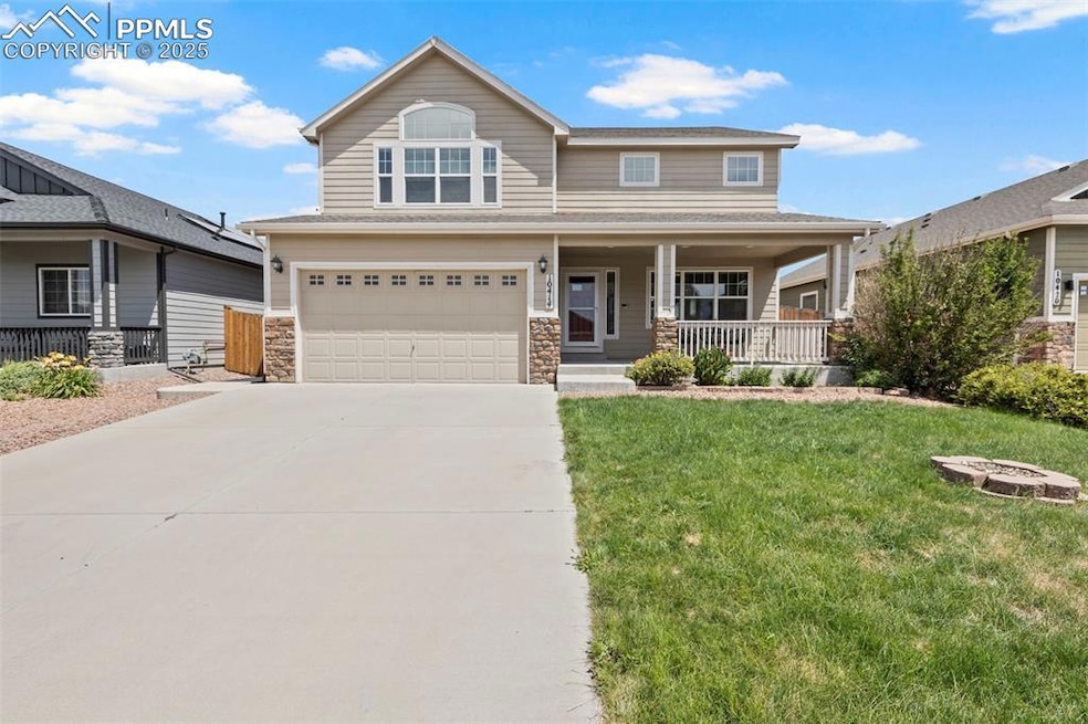


Spacious home over 3200 sq ft with room for everyone! Huge primary retreat takes over half of the upstairs while two bedrooms have their own bathroom and loft for their own hang out space. Full finished basement for that teen in your life or multi-generational living. Their own bedroom, bathroom and wet bar to keep those snacks in!
Step into the heart of the home—a beautifully designed gourmet kitchen equipped with high-end appliances, ample counter space, and elegant finishes, perfect for home chefs and everyday living. The open-concept main level flows seamlessly into the living and dining areas, all connected to a cute mudroom leading out into a spacious 3-car tandem garage offering extra storage or hobby space.
Upstairs, you'll find an expansive master retreat that spans one entire side of the home. This luxurious suite features a huge master bedroom, dual walk-in closets, and a spa-like en-suite bath that connects directly to the laundry room for added convenience. Across the upper level are two additional bedrooms, a bathroom and a spacious loft that offers the perfect bonus space for a playroom or home office!
Enjoy the mornings on your huge covered front porch with a cup of coffee and Enjoy warm Colorado evenings in the fully fenced backyard, complete with an extended patio ideal for dining, relaxing, or entertaining under the stars. The home also includes an internal Internet system and a sprinkler system with drip irrigation for the vibrant front flower beds.
Located in a desirable community with parks, trails, and a school just steps away. Community events and food trucks are a normal thing in this neighborhood! This home offers the perfect balance of suburban comfort and accessibility—close to shopping, dining, and military bases.
Don't miss this exceptional opportunity to make this house your home! ***Quick closing available***
Last Agent to Sell the Property
Premier Real Estate Colorado LLC Listed on: 07/08/2025
| Date | Type | Sale Price | Title Company |
|---|---|---|---|
| Warranty Deed | $475,000 | First American Title | |
| Warranty Deed | $360,000 | Land Title Guarantee Co | |
| Warranty Deed | $303,095 | Unified Title Company | |
| Warranty Deed | $183,465 | None Available |
| Date | Status | Loan Amount | Loan Type |
|---|---|---|---|
| Open | $466,396 | FHA | |
| Previous Owner | $371,880 | VA | |
| Previous Owner | $313,097 | VA |
| Date | Event | Price | List to Sale | Price per Sq Ft |
|---|---|---|---|---|
| 09/30/2025 09/30/25 | Sold | $475,000 | 0.0% | $147 / Sq Ft |
| 09/09/2025 09/09/25 | Pending | -- | -- | -- |
| 09/03/2025 09/03/25 | Price Changed | $475,000 | -4.8% | $147 / Sq Ft |
| 08/13/2025 08/13/25 | Price Changed | $499,000 | -3.1% | $154 / Sq Ft |
| 07/26/2025 07/26/25 | Price Changed | $515,000 | -1.9% | $159 / Sq Ft |
| 07/08/2025 07/08/25 | For Sale | $525,000 | -- | $162 / Sq Ft |
| Year | Tax Paid | Tax Assessment Tax Assessment Total Assessment is a certain percentage of the fair market value that is determined by local assessors to be the total taxable value of land and additions on the property. | Land | Improvement |
|---|---|---|---|---|
| 2025 | $4,896 | $34,960 | -- | -- |
| 2024 | $4,857 | $36,220 | $6,040 | $30,180 |
| 2022 | $3,617 | $26,130 | $4,810 | $21,320 |
| 2021 | $3,766 | $26,880 | $4,950 | $21,930 |
| 2020 | $3,714 | $26,230 | $4,330 | $21,900 |
| 2019 | $3,702 | $26,230 | $4,330 | $21,900 |
| 2018 | $2,994 | $20,890 | $4,360 | $16,530 |
| 2017 | $3,057 | $20,890 | $4,360 | $16,530 |
| 2016 | $2,999 | $23,170 | $4,380 | $18,790 |
| 2015 | $3,159 | $23,170 | $4,380 | $18,790 |
| 2014 | -- | $10,860 | $10,860 | $0 |
Seller's Agent in 2025
Kristel Bryan
Premier Real Estate Colorado LLC
(502) 594-5228
8 in this area
34 Total Sales
Buyer's Agent in 2025
Jeffrey Johnson
Keller Williams Premier Realty
(719) 930-5169
60 in this area
997 Total Sales
Source: Pikes Peak REALTOR® Services
MLS Number: 4382612
APN: 55144-16-019
Disclaimer: Certain information contained herein is derived from information provided by parties other than Homes.com. All information provided is deemed reliable, but is not guaranteed to be accurate and should be independently verified.
![]() IDX information is provided exclusively for personal, non-commercial use, and may not be used for any purpose other than to identify prospective properties consumers may be interested in purchasing. Information is deemed reliable but not guaranteed.
IDX information is provided exclusively for personal, non-commercial use, and may not be used for any purpose other than to identify prospective properties consumers may be interested in purchasing. Information is deemed reliable but not guaranteed.