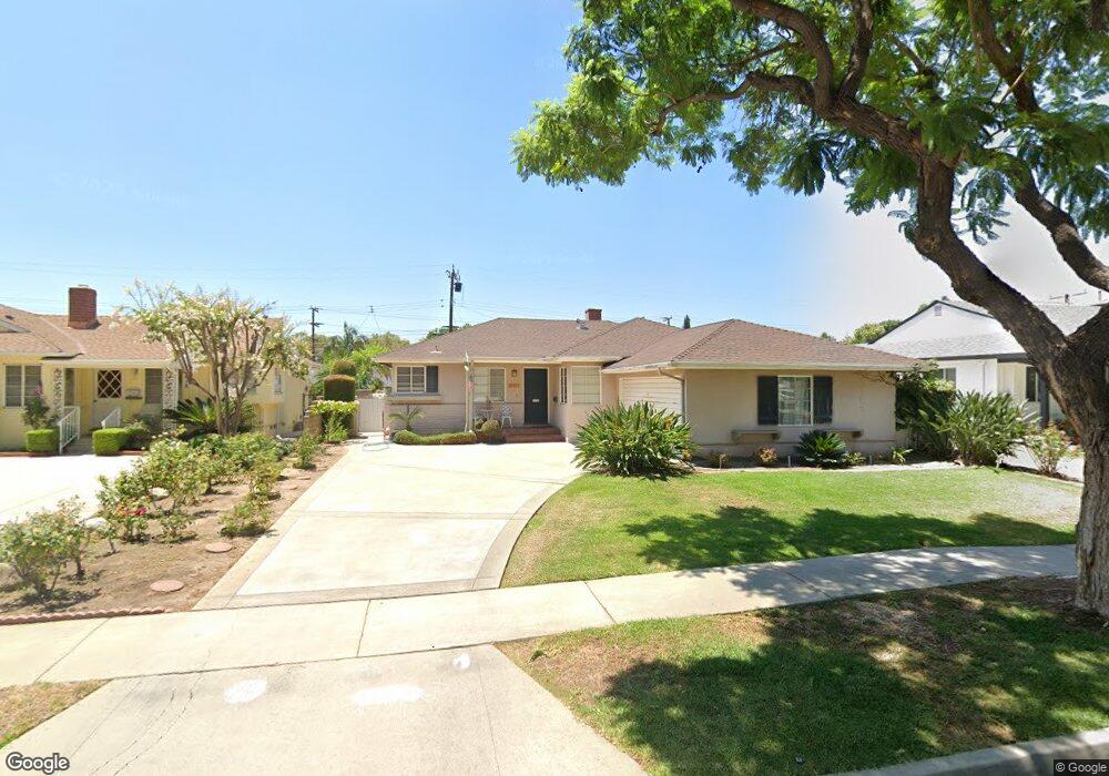
10417 Woodstead Ave Whittier, CA 90603
South Whittier NeighborhoodEstimated Value: $831,329 - $902,000
3
Beds
2
Baths
1,378
Sq Ft
$626/Sq Ft
Est. Value
About This Home
This home is located at 10417 Woodstead Ave, Whittier, CA 90603 and is currently estimated at $862,082, approximately $625 per square foot. 10417 Woodstead Ave is a home located in Los Angeles County with nearby schools including Leffingwell Elementary School, Granada Middle School, and La Serna High School.
Ownership History
Date
Name
Owned For
Owner Type
Purchase Details
Closed on
Oct 5, 2011
Sold by
Maxfield Thomas C and Monfore Carolyn
Bought by
Duron Ralph and Duron Emilia
Current Estimated Value
Home Financials for this Owner
Home Financials are based on the most recent Mortgage that was taken out on this home.
Original Mortgage
$333,000
Outstanding Balance
$225,470
Interest Rate
3.95%
Mortgage Type
New Conventional
Estimated Equity
$636,612
Purchase Details
Closed on
Jun 13, 2011
Sold by
Maxfield Kathryn Irene and Maxfield Kathryn I
Bought by
Maxfield Thomas C and Monfore Carolyn
Purchase Details
Closed on
Mar 13, 1996
Sold by
Maxfield Kathryn I
Bought by
Maxfield Kathryn I and The Maxfield Family Trust
Create a Home Valuation Report for This Property
The Home Valuation Report is an in-depth analysis detailing your home's value as well as a comparison with similar homes in the area
Home Values in the Area
Average Home Value in this Area
Purchase History
| Date | Buyer | Sale Price | Title Company |
|---|---|---|---|
| Duron Ralph | $370,000 | Fidelity Natonal Title Co | |
| Maxfield Thomas C | -- | None Available | |
| Maxfield Kathryn I | -- | -- |
Source: Public Records
Mortgage History
| Date | Status | Borrower | Loan Amount |
|---|---|---|---|
| Open | Duron Ralph | $333,000 |
Source: Public Records
Tax History Compared to Growth
Tax History
| Year | Tax Paid | Tax Assessment Tax Assessment Total Assessment is a certain percentage of the fair market value that is determined by local assessors to be the total taxable value of land and additions on the property. | Land | Improvement |
|---|---|---|---|---|
| 2025 | $5,778 | $464,730 | $264,897 | $199,833 |
| 2024 | $5,778 | $455,618 | $259,703 | $195,915 |
| 2023 | $5,671 | $446,685 | $254,611 | $192,074 |
| 2022 | $5,544 | $437,927 | $249,619 | $188,308 |
| 2021 | $5,391 | $429,341 | $244,725 | $184,616 |
| 2019 | $5,266 | $416,608 | $237,467 | $179,141 |
| 2018 | $5,058 | $408,440 | $232,811 | $175,629 |
| 2016 | $4,788 | $392,582 | $223,772 | $168,810 |
| 2015 | $4,760 | $386,686 | $220,411 | $166,275 |
| 2014 | $4,711 | $379,112 | $216,094 | $163,018 |
Source: Public Records
Map
Nearby Homes
- 10517 La Serna Dr
- 15413 Ashley Ct
- 15309 Jenkins Dr
- 10010 Cole Rd
- 16428 Whittier Blvd Unit 2
- 15069 Mulberry Dr
- 15914 Lashburn St
- 16046 Gables Loop
- 11237 Gladhill Rd Unit 3
- 11237 Gladhill Rd Unit 12
- 11237 Gladhill Rd Unit 5
- 11237 Gladhill Rd Unit 15
- 15246 Mystic St
- 11124 Stamy Rd
- 11245 Gladhill Rd Unit 10
- 16121 Lisco St
- 14816 Lanning Dr
- 16164 Leffco Rd
- 10847 La Mirada Blvd
- 11548 Kibbee Ave
- 10411 Woodstead Ave
- 10423 Woodstead Ave
- 10418 Scott Ave
- 10405 Woodstead Ave
- 10424 Scott Ave
- 10427 Woodstead Ave
- 10412 Scott Ave
- 10430 Scott Ave
- 10418 Woodstead Ave
- 10404 Scott Ave
- 10359 Woodstead Ave
- 10382 Woodstead Ave
- 10426 Woodstead Ave
- 10412 Woodstead Ave
- 10433 Woodstead Ave
- 10436 Scott Ave
- 10370 Scott Ave
- 10434 Woodstead Ave
- 10376 Woodstead Ave
- 10353 Woodstead Ave