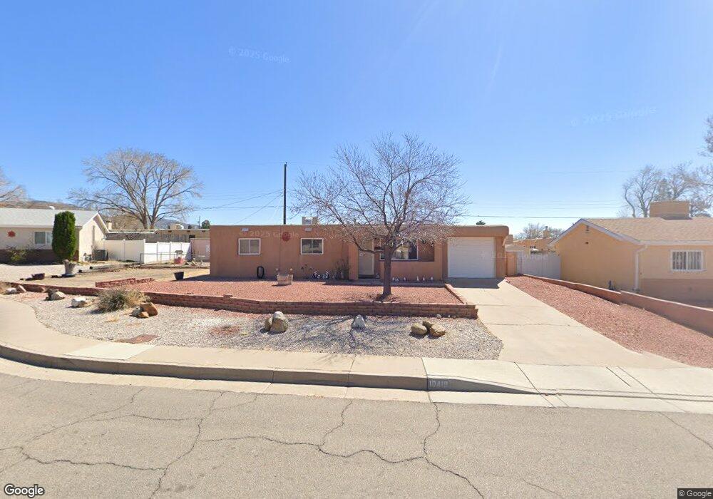
10418 Britt Ct NE Albuquerque, NM 87112
Jackson Area NeighborhoodEstimated Value: $252,000 - $295,000
2
Beds
2
Baths
1,008
Sq Ft
$274/Sq Ft
Est. Value
About This Home
This home is located at 10418 Britt Ct NE, Albuquerque, NM 87112 and is currently estimated at $276,063, approximately $273 per square foot. 10418 Britt Ct NE is a home located in Bernalillo County with nearby schools including Collet Park Elementary School, Jackson Middle School, and Manzano High School.
Ownership History
Date
Name
Owned For
Owner Type
Purchase Details
Closed on
Jun 13, 2023
Sold by
Latham Carroll Gene
Bought by
Latham Carroll Gene
Current Estimated Value
Purchase Details
Closed on
Mar 7, 2008
Sold by
Latham Carroll Gene and Latham Kathleen L
Bought by
Latham Carroll Gene and Latham Kathleen L
Home Financials for this Owner
Home Financials are based on the most recent Mortgage that was taken out on this home.
Original Mortgage
$16,500
Interest Rate
5.72%
Mortgage Type
Credit Line Revolving
Purchase Details
Closed on
Jul 16, 1979
Sold by
Berry Earl and Berry Opal M
Bought by
Latham Carroll Gene and Latham Mary Louise
Create a Home Valuation Report for This Property
The Home Valuation Report is an in-depth analysis detailing your home's value as well as a comparison with similar homes in the area
Home Values in the Area
Average Home Value in this Area
Purchase History
| Date | Buyer | Sale Price | Title Company |
|---|---|---|---|
| Latham Carroll Gene | -- | None Listed On Document | |
| Latham Carroll Gene | -- | None Available | |
| Latham Carroll Gene | -- | None Available |
Source: Public Records
Mortgage History
| Date | Status | Borrower | Loan Amount |
|---|---|---|---|
| Previous Owner | Latham Carroll Gene | $16,500 |
Source: Public Records
Tax History Compared to Growth
Tax History
| Year | Tax Paid | Tax Assessment Tax Assessment Total Assessment is a certain percentage of the fair market value that is determined by local assessors to be the total taxable value of land and additions on the property. | Land | Improvement |
|---|---|---|---|---|
| 2025 | $1,190 | $49,920 | $12,634 | $37,286 |
| 2024 | $1,190 | $48,466 | $12,266 | $36,200 |
| 2023 | $1,182 | $47,054 | $11,909 | $35,145 |
| 2022 | $1,858 | $45,685 | $11,563 | $34,122 |
| 2021 | $1,793 | $44,354 | $11,226 | $33,128 |
| 2020 | $1,761 | $43,062 | $10,899 | $32,163 |
| 2019 | $890 | $42,004 | $13,395 | $28,609 |
| 2018 | $1,652 | $42,004 | $13,395 | $28,609 |
| 2017 | $1,599 | $40,781 | $13,005 | $27,776 |
| 2016 | $1,550 | $38,440 | $12,259 | $26,181 |
| 2015 | $37,321 | $37,321 | $11,902 | $25,419 |
| 2014 | $748 | $36,234 | $11,555 | $24,679 |
| 2013 | -- | $35,179 | $11,219 | $23,960 |
Source: Public Records
Map
Nearby Homes
- 10410 Towner Ave NE
- 1800 Pitt St NE
- 2417 Britt St NE
- 1801 June St NE
- 1812 Mary Ellen St NE
- 11008 Morris Ct NE
- 32 Lakeshore Dr NE
- 11600 Snowheights Blvd NE
- 11609 Baldwin Ave NE
- 1724 Glorieta St NE
- 9521 Salem Rd NE
- 10708 Lexington Ave NE
- 9616 Morrow Ave NE
- 1704 Shirley St NE
- 2700 Eubank Blvd NE
- 9716 Indian School Rd NE
- 9521 Snow Heights Blvd NE
- 2805 Christine St NE
- 1613 Glorieta St NE
- 2905 Dorothy St NE
- 10412 Britt Ct NE
- 10424 Britt Ct NE
- 10509 Apache Ave NE
- 10424 Britt Ct NE
- 10505 Apache Ave NE
- 10513 Apache Ave NE
- 10419 Britt Ct NE
- 10408 Britt Ct NE
- 10501 Apache Ave NE
- 10413 Britt Ct NE
- 10428 Britt Ct NE
- 10425 Britt Ct NE
- 10601 Apache Ave NE
- 10413 Apache Ave NE
- 10404 Britt Ct NE
- 10605 Apache Ave NE
- 10405 Britt Ct NE
- 10424 Prospect Ave NE
- 10416 Prospect Ave NE
- 10422 Prospect Ave NE