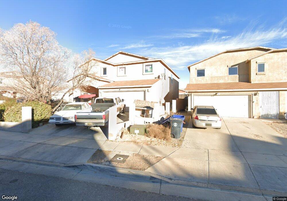
10419 Range Rd SW Albuquerque, NM 87121
Southwest Heights NeighborhoodEstimated Value: $344,000 - $382,000
4
Beds
3
Baths
3,040
Sq Ft
$119/Sq Ft
Est. Value
About This Home
This home is located at 10419 Range Rd SW, Albuquerque, NM 87121 and is currently estimated at $361,864, approximately $119 per square foot. 10419 Range Rd SW is a home located in Bernalillo County with nearby schools including Carlos Rey Elementary School, Tony Hillerman Middle School, and Atrisco Heritage Academy High School.
Ownership History
Date
Name
Owned For
Owner Type
Purchase Details
Closed on
Dec 16, 2010
Sold by
Diaz Francisco V
Bought by
Diaz Francisco and Diaz Martha
Current Estimated Value
Home Financials for this Owner
Home Financials are based on the most recent Mortgage that was taken out on this home.
Original Mortgage
$148,975
Outstanding Balance
$101,045
Interest Rate
4.75%
Mortgage Type
FHA
Estimated Equity
$260,819
Purchase Details
Closed on
Jul 20, 2007
Sold by
Centex Homes
Bought by
Diaz Francisco
Home Financials for this Owner
Home Financials are based on the most recent Mortgage that was taken out on this home.
Original Mortgage
$119,000
Interest Rate
6.54%
Mortgage Type
Purchase Money Mortgage
Create a Home Valuation Report for This Property
The Home Valuation Report is an in-depth analysis detailing your home's value as well as a comparison with similar homes in the area
Home Values in the Area
Average Home Value in this Area
Purchase History
| Date | Buyer | Sale Price | Title Company |
|---|---|---|---|
| Diaz Francisco | -- | Fidelity Natl Title Ins Co | |
| Diaz Francisco | -- | Commerce Title |
Source: Public Records
Mortgage History
| Date | Status | Borrower | Loan Amount |
|---|---|---|---|
| Open | Diaz Francisco | $148,975 | |
| Closed | Diaz Francisco | $119,000 |
Source: Public Records
Tax History Compared to Growth
Tax History
| Year | Tax Paid | Tax Assessment Tax Assessment Total Assessment is a certain percentage of the fair market value that is determined by local assessors to be the total taxable value of land and additions on the property. | Land | Improvement |
|---|---|---|---|---|
| 2024 | $2,928 | $71,405 | $14,959 | $56,446 |
| 2023 | $2,877 | $69,326 | $14,523 | $54,803 |
| 2022 | $2,778 | $67,306 | $14,100 | $53,206 |
| 2021 | $2,682 | $65,346 | $13,689 | $51,657 |
| 2020 | $2,636 | $63,443 | $13,291 | $50,152 |
| 2019 | $2,556 | $61,596 | $12,904 | $48,692 |
| 2018 | $2,462 | $61,596 | $12,904 | $48,692 |
| 2017 | $2,384 | $59,802 | $12,528 | $47,274 |
| 2016 | $2,313 | $56,369 | $11,809 | $44,560 |
| 2015 | $54,728 | $54,728 | $11,466 | $43,262 |
| 2014 | $2,260 | $55,228 | $11,466 | $43,762 |
| 2013 | -- | $55,728 | $11,466 | $44,262 |
Source: Public Records
Map
Nearby Homes
- 10427 Sandy Flats Ave SW
- 2105 Hermosa Creek Dr SW
- 2401 Ghost Ranch St SW
- 10915 Denton Rd SW
- 10608 Buck Island Rd SW
- 2204 San Leon St SW
- 10760 Four Mile Rd SW
- 2615 Silver Star Dr SW
- 11024 Bowie Rd SW
- 2408 Sun Gate Trail SW
- 2704 Ghost Ranch St SW Unit 15
- 10519 Valedon Ln SW
- Plan 3014 - The Sierra at Aspire
- Plan 3004 - The Sawyer at Aspire
- Plan 3013 - The Sophia at Aspire
- 2627 Sun Canyon Ln SW
- 10820 Corona Ranch Rd SW
- 10516 Valedon Ln SW
- 10512 Valedon Ln SW
- 9909 Saddlehorn Trail SW
- 10415 Range Rd SW
- 10409 Range Rd SW
- 2119 Rolling Ridge Dr SW
- 0 2119 Rolling Ridge Unit 704413
- 2115 Rolling Ridge Dr SW
- 2123 Rolling Ridge Dr SW
- 10444 Gila Gulch Rd SW
- 10405 Range Rd SW
- 10416 Range Rd SW
- 10440 Gila Gulch Rd SW
- 10420 Range Rd SW
- 10500 Range Rd SW
- 10436 Gila Gulch Rd SW
- 2109 Rolling Ridge Dr SW
- 10412 Range Rd SW
- 10504 Range Rd SW
- 2105 Rolling Ridge Dr SW
- 10508 Range Rd SW
- 10408 Range Rd SW
- 10432 Gila Gulch Rd SW