Estimated Value: $135,000 - $218,000
2
Beds
1
Bath
1,108
Sq Ft
$171/Sq Ft
Est. Value
About This Home
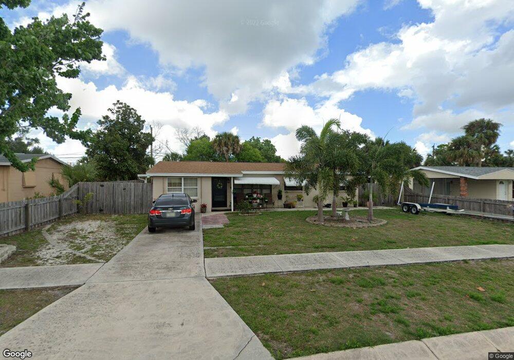
This home is located at 1042 Barclay Dr, Cocoa, FL 32927 and is currently estimated at $189,842, approximately $171 per square foot. 1042 Barclay Dr is a home located in Brevard County with nearby schools including Atlantis Elementary School, Space Coast Junior/Senior High School, and East Atlantic Prep of Brevard County.
Ownership History
Date
Name
Owned For
Owner Type
Purchase Details
Closed on
Oct 12, 2018
Sold by
Barnett Teresa A
Bought by
Cheek Kalynn Lee Barnett and Cheek Derek Linwood
Current Estimated Value
Purchase Details
Closed on
Apr 7, 2014
Sold by
Miller Joseph A and Miller Lora R
Bought by
Barnett Teresa A
Purchase Details
Closed on
Jan 4, 1999
Sold by
Hurst David W and Hurst Blanche
Bought by
Miller Joseph A and Miller Lora R
Home Financials for this Owner
Home Financials are based on the most recent Mortgage that was taken out on this home.
Original Mortgage
$32,000
Interest Rate
6.77%
Create a Home Valuation Report for This Property
The Home Valuation Report is an in-depth analysis detailing your home's value as well as a comparison with similar homes in the area
Home Values in the Area
Average Home Value in this Area
Purchase History
| Date | Buyer | Sale Price | Title Company |
|---|---|---|---|
| Cheek Kalynn Lee Barnett | -- | Attorney | |
| Barnett Teresa A | $45,000 | Attorney | |
| Miller Joseph A | $40,000 | -- |
Source: Public Records
Mortgage History
| Date | Status | Borrower | Loan Amount |
|---|---|---|---|
| Previous Owner | Miller Joseph A | $32,000 |
Source: Public Records
Tax History
| Year | Tax Paid | Tax Assessment Tax Assessment Total Assessment is a certain percentage of the fair market value that is determined by local assessors to be the total taxable value of land and additions on the property. | Land | Improvement |
|---|---|---|---|---|
| 2025 | $908 | $55,780 | -- | -- |
| 2024 | $891 | $54,210 | -- | -- |
| 2023 | $891 | $52,640 | $0 | $0 |
| 2022 | $854 | $51,110 | $0 | $0 |
| 2021 | $330 | $49,630 | $0 | $0 |
| 2020 | $798 | $48,950 | $0 | $0 |
| 2019 | $736 | $47,850 | $0 | $0 |
| 2018 | $728 | $46,960 | $0 | $0 |
| 2017 | $717 | $46,000 | $0 | $0 |
| 2016 | $710 | $45,060 | $18,000 | $27,060 |
| 2015 | $707 | $44,750 | $15,000 | $29,750 |
| 2014 | $487 | $31,480 | $11,000 | $20,480 |
Source: Public Records
Map
Nearby Homes
- 1040 Jersey St
- 1029 Illinois Rd
- 1050 Barclay Dr
- 1014 Illinois Rd
- 361 Payne Ave
- 977 Poinsetta St
- 973 Poinsetta St
- 414 Oakridge Ave
- 7060 N Highway 1 Unit AA206
- 7060 N Highway 1 Unit 205
- 7060 N Highway 1 Unit AA102
- 961 Kaufman St
- 7030 N Highway 1 Unit 101
- 7030 N Highway 1 Unit B-106
- 7030 N Highway 1 Unit DD102
- 7000 N Highway 1 Unit Gg-205
- 7020 N Highway 1 Unit EE202
- 7240 N Highway 1 Unit 106
- 7170 N Highway 1 Unit 103
- 985 Tope St
- 1046 Barclay Dr
- 1038 Barclay Dr
- 1056 Jersey St
- 449 Camel Cir
- 1034 Barclay Dr
- 1043 Jersey St
- 1047 Jersey St
- 1039 Jersey St
- 1051 Jersey St
- 453 Camel Cir
- 1054 Barclay Dr
- 1030 Barclay Dr
- 1029 Barclay Dr
- 1055 Jersey St
- 1058 Barclay Dr
- 1044 Jersey St
- 1028 Barclay Dr
- 1031 Jersey St
- 462 Camel Cir
- 464 Camel Cir
Your Personal Tour Guide
Ask me questions while you tour the home.